
Weekly Citrus Weather For January 7, 2025
Kansas City, January 7 (World Weather Inc.) – Florida’s citrus areas were mostly dry during the past week and will receive limited rainfall in the coming days. Nighttime temperatures dropped to the 30s Fahrenheit at times in the northern citrus counties and will again cool to the 30s on a frequent basis during the coming week. No damaging conditions are expected. Brazil’s citrus areas saw a good mix of rain and sunshine during the past week with more on the way during the coming week. Development conditions will remain generally favorable, though yields are still expected to trend lower than usual this season mostly due to greening disease. Mexico will be unusually wet during the coming week. Early-season flowering may occur in areas that receive the greatest amount of rain.
Next U.S. Winter Storm Occurs Thursday Into Saturday
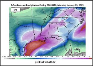
Kansas City, January 7 (World Weather Inc.) – A late week winter storm will bring a mix of precipitation types from central and eastern Texas through the Delta to the middle Atlantic Coast States Thursday into Saturday. The storm will bring travel delays, livestock stress and more moisture to these areas. There will be some potential for power outages because of ice accumulations in a few areas, although freezing rain should not be a widespread problem. In the meantime, another round of significant snowfall is expected.
U.S. Will Be Impacted By Active Weather Pattern
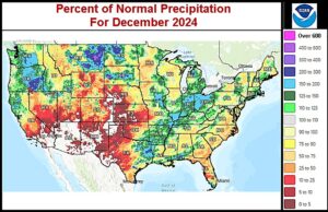
Kansas City, January 3 (World Weather Inc.) – Drought or abnormally dry conditions persist from portions of the U.S. Plains into the Upper Midwest and southeastern states. The most extreme drought was noted in portions of the northern Plains despite several locations receiving above normal precipitation during the past month. An active weather pattern is slated for the U.S. in the coming week, most notably a strong winter storm that will impact portions of the central Plains and Midwest later this weekend and early next week. Major travel delays and animal stress are expected, though the moisture will eventually be welcome when melting and reaching the soil. The Delta and southeastern states will also receive enough precipitation to marginally improve the moisture profile as will Montana while precipitation is limited elsewhere in the northern Plains.
U.S. Midwest Storm Promises Power Outages, Road Closures
Kansas City, January 3 (World Weather Inc.) – The first major winter storm of the season in the lower Midwest will evolve this weekend. The lack of big storms in the Midwest so far this season has kept commerce flowing freely and holiday travel advanced with very few issues except in the northeastern corner of the nation. An aggressive low pressure center expected to form Saturday in the southwestern U.S. Plains will bring copious amounts of sleet, freezing rain and snow from Kansas and southern Nebraska to Ohio, Virginia and Kentucky. The storm will disrupt electrical power, close some roads and airports and stress livestock. Bitter cold conditions will follow the storm and blizzard conditions may briefly develop as the storm is abating from the region.
Weekly Citrus Weather for Wednesday, January 1, 2025
Kansas City, January 1 (World Weather Inc.) – Florida’s citrus areas saw periods of spotty rainfall during the past week. No major harvest delays were suspected and the environment remained favorable for ongoing fruit and tree development. The main citrus areas will receive little or no rain during the coming week and irrigation will likely be used most days. Brazil’s citrus areas again received significant rain during the past week. Although rain totals through early next week will be slightly lower than usual in some locations, most areas will have ample moisture to maintain aggressive growth. East-central and northeastern Mexico will have opportunities for erratic rainfall through this weekend that may disrupt the harvest and general farming activity.
Weekly Citrus Weather for Tuesday, December 24, 2024
Kansas City, December 24 (World Weather Inc.) – In Florida, frequent and often significant rain was noted near the Atlantic coastline during the past week. Harvesting may have been impacted by the rain, though no major quality impacts were suspected. Florida will be unusually wet during the coming week, which will ease the need for irrigation. Brazil’s citrus areas received rain on a frequent basis during the past week with more on the way during the coming week. Citrus conditions will remain favorable. However, yield potentials will remain lower than usual for the upcoming season. Mexico’s citrus areas will receive limited rainfall during the coming week. The harvest will continue with few disruptions.
U.S. Hard Red Winter Wheat Still Rated Well Despite Dryness
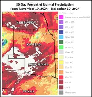
Kansas City, December 19 (World Weather Inc.) – Minimal to no precipitation has occurred in U.S. hard red winter wheat country in the past 30-days; however, in the previous 30 days, significantly more precipitation than usual occurred with over four times the norm reported in most of the crop region. The abundance of precipitation in late October and early November coupled with seasonal cooling has conserved soil moisture so that it remains at relatively favorable levels, despite dry weather. Crops are dormant or semi-dormant, though warmer-than-average temperatures in the next two weeks may reduce crop hardiness and cooling will soon be needed along with perhaps some snow. Minimal precipitation is expected to continue in at least the next 5-days with the high Plains region probably staying dry biased for up to ten days. There is not much immediate need for precipitation as long as cooler biased conditions return in January.
U.S. Pacific Northwest, British Columbia Rain To Slow Shipping
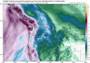
Kansas City, December 18 (World Weather Inc.) – A succession of disturbances will generate waves of precipitation for the U.S. Pacific Northwest, southwestern British Columbia, and neighboring locations for at least the next seven to ten days. The frequent precipitation may slow port activities in and around the Puget Sound and neighboring areas of British Columbia. Mountain snowpack will also increase significantly for portions of the Cascades and northern Rocky Mountains. Precipitation will also reach the main production areas of the Pacific Northwest, though precipitation totals will be much lower compared to areas closer to the coastline. The combination of precipitation and increased mountain snowpack will support a better outlook for the winter grains.
Weekly Citrus Weather for Tuesday, December 17, 2024
Kansas City, December 17 (World Weather Inc.) – Florida’s citrus region saw sporadic rain combined with brief periods of cool weather during the past week. No damaging conditions were noted and harvesting advanced around the precipitation. The region will again have opportunities for rain in the coming days that may further slow or delay the harvest. Brazil’s citrus areas received rain on a frequent basis during the past week and more of the same was expected in this coming week keeping crop conditions rated favorably. Mexico will experience unusually wet weather during the coming week that may slow harvest progress, most notably in Veracruz.
North America Temperatures To Finish December Quite Warm
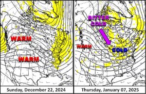
Kansas City, December 16 (World Weather Inc.) – Canada’s Prairies and the far northern U.S. Plains have been among the few regions of the world that have seen bitter cold so far this winter. The cold is expected to prevail this week and then abate leaving North America in a much warmer than usual temperature regime for the balance of December. The earliest that cold weather will return to Canada will be in early January, although there is some suggestion that the cold will eventually stream into the eastern parts of North America by the second week of January. Until then, heating fuel demand will be low and some of the snow cover present to day may melt away.
California Snowpack Above Normal; Dry, Warm Weather Ahead
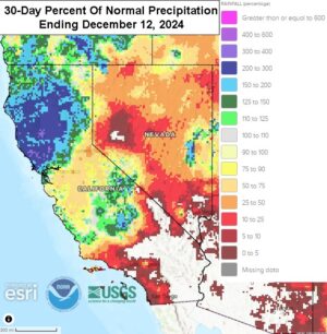
Kansas City, December 13 (World Weather Inc.) – Water reservoir levels across California are generally near or above historical levels. Waves of precipitation in recent weeks have also helped lift snowpack near or above historical levels for this time of year in the northern and southern Sierra Nevada while central sections of the Sierra Nevada have lower than usual snow. Two disturbances will continue to promote waves of precipitation for the northern half of the state through early next week. Development of a high-pressure ridge over western North America is otherwise expected later next week and will likely remain over the region into the second week of the outlook. The ridge will restrict precipitation and promote warmer than normal conditions.
Drought Conditions Developing Along Southeast U.S. Coastline
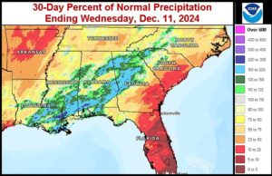
Kansas City, December 12 (World Weather Inc.) – Thirty-day rainfall deficits between 1.00 and 3.00 inches are present from the North Carolina coastline southward through central and eastern South Carolina and southeastern Georgia to parts of Florida. Moderate drought conditions have evolved across parts of this region and in the next seven days minimal to no precipitation is expected across the Carolinas and Georgia. If this forecast verifies, much more precipitation will be needed to alleviate moisture deficits and to eventually support planting of spring crops in the coming months.
U.S. Northeast Susceptible To Additional Flooding
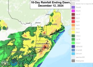
Kansas City, December 12 (World Weather Inc.) – Stormy weather underway in the northeastern United States this week has begun to erode drought conditions that have prevailed for a while. The region experienced the driest September-October period on record this year followed by below normal precipitation in November. More frequent precipitation was noted to start December with more rain and snow on the way during the next two weeks. The waves of precipitation combined with melting snow will likely lead to flooding. Travel may be disrupted at times and damage to infrastructure is likely.
Weekly Citrus Weather For December 10, 2024
Kansas City, December 10 (World Weather Inc.) – Florida’s citrus areas were generally dry during the past week with little rain on the way during the coming week. Irrigation will be the primary source for moisture and conditions will remain favorable. Harvesting will also advance swiftly around the rain. Brazil’s citrus areas will continue to receive rain on a frequent basis during the coming week. Citrus conditions will remain favorable, though yields are still trending lower than usual. In Mexico, spotty rain may periodically impact harvesting through early next week.
U.S. Pacific Northwest Needs Greater Moisture By Spring
Kansas City, December 10 (World Weather Inc.) – The U.S. Pacific Northwest crop region has seen little precipitation in the past two weeks. Soil moisture is marginal to short across most of the crop region with abnormally dry to moderate drought conditions occurring in much of the region as well. Water reservoirs are also critically low in many areas throughout the Yakima Valley. Winter crops are dormant and the need for moisture is low for now, but a big improvement in soil moisture and water supply is needed by spring to protect unirrigated winter crop production potential and to support spring planting.
U.S. Plains Precipitation Potentials To Increase Mid-December
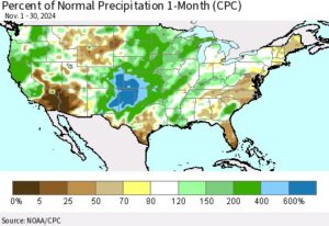
Kansas City, December 6 (World Weather Inc.) – Winter crops established under relatively favorable conditions this autumn in the U.S. hard red winter wheat country. The high Plains received well above normal precipitation in November that not only supported good establishment, but also long-term conditions. Many areas in the northern Plains were not significantly relieved from drought and areas from Montana to South Dakota and Nebraska are still drought stricken and in need of timely precipitation over the winter. There is potential for a more active weather pattern during the second week of the outlook that could bring precipitation to portions of hard red wheat country, though the northwestern Plains may be missed.
SE U.S. Rain To Bolster Soil Moisture; Flooding Possible
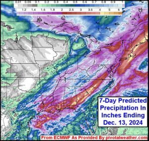
Kansas City, December 5 (World Weather Inc.) – The Gulf of Mexico will help funnel moisture into the U.S. through the latter part of next week. The moisture combined with disturbances tracking nearby will generate periods of precipitation from eastern Texas through the Delta and lower Midwest to the Atlantic Coast States. The precipitation will gradually bolster soil moisture with localized flooding possible in the lower Delta and interior parts of the southeastern states. The moisture will otherwise be beneficial for the winter crops in the Midwest and portions of the southeastern states where net drying has been occurring. Snow in the U.S. northeast will also impact travel and could damage infrastructure.
Weekly Citrus Weather For Tuesday, December 3, 2024
Kansas City, December 3 (World Weather Inc.) – The northwest corner of citrus country in Florida saw temperatures dip near or slightly below freezing at times in recent mornings. No widespread freezes were noted and overall damage should be minimal. The region otherwise received little to no rain and will remain drier biased in the coming week. The harvest will advance swiftly. Brazil’s citrus areas saw several waves of rain during the past week with more on the way in the coming days. Citrus conditions will remain favorable, though production is still expected to be lower than usual. Mexico will receive some erratic rainfall in the coming days that may slow the harvest.
U.S. Cold To Increase Energy Demands; No Major Crop Impacts
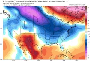
Kansas City, November 27 (World Weather Inc.) – The first outbreak of winter cold weather will evolve in portions of the United States outside the southwest in the coming days. Temperatures will drop below to well below normal with the greatest deviation from normal temperatures occurring in the northern Plains and Midwest. Energy demands will increase and there is potential for upper portions of the Missouri and Mississippi Rivers to freeze. Barge traffic may be impacted due to lower river levels. Impacts to crops will be minimal as temperatures will not cool enough to damage winter grains. Light snow will otherwise occur in portions of the Plains and Midwest in the coming days as the colder air pushes into the U.S. Livestock may be stressed in areas that experience the coldest weather.
Weekly Citrus Weather For November 26, 2024
Kansas City, November 26 (World Weather Inc.) – Precipitation was limited for much of Florida during the past week and will remain limited during the coming week. The environment was and will remain favorable for harvesting and general farming activity. Irrigation will continue to support good conditions for the citrus that is still growing. In Brazil, many areas in Sao Paulo received little or no rain during the past week. More frequent precipitation is slated for the region during the coming week and will support favorable development conditions. Yields are trending to be some of the lowest levels in years due largely to greening conditions. Mexico’s citrus areas will see relatively good conditions for harvesting during the coming week.
Northern California, Oregon Storm Summary In Graphics
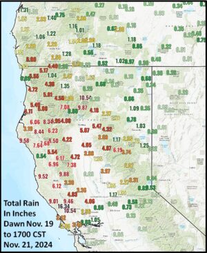
Kansas City, November 21 (World Weather Inc.) – Northern California and southwestern Oregon’s excessive rain and wind event has lived up to its expectations. Today’s wind speeds subsided across the region, but speeds Tuesday and Wednesday were damaging in some areas. Flooding is the next issue with rainfall already varying from 4.00 to 11.00 inches across the region and additional amounts of 2.00 to 8.00 inches likely by Saturday evening. Flooding will worsen before it gets better.
U.S. November Weather Improves Wheat Prospects
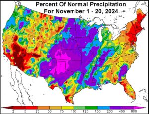
Kansas City, November 20 (World Weather Inc.) – Waves of significant rain and some snow from the southwestern U.S. Plains through most of the Midwest this month has notably improved soil moisture and drought conditions. Portions of Colorado and southwestern Nebraska remain a little dry to support ideal long-term conditions, though the outlook is much improved compared to the beginning of planting season. The region will trend drier biased through the middle of next week, which will be beneficial for any late-season planting and fieldwork. The Midwest also has ample moisture that will be beneficial for winter wheat establishment after a drier than usual month of October.
Weekly Citrus Weather for Tuesday, November 19, 2024
Kansas City, November 19 (World Weather Inc.) – Negligible rainfall in Florida citrus areas during the past week induced a good environment for hurricane damage recovery and general farming activity. The upcoming season’s yields are expected to be some of the lowest on record in part due to damage from Hurricane Milton. A strong frontal boundary will bring rain to Florida Wednesday that may disrupt harvesting and general farming activity while also reducing the need for irrigation. Drier weather later in the forecast period will again support better conditions for the harvest. Brazil’s citrus areas saw a mix of spotty rain and sunshine during the past week with more of the same coming. Portions of Sao Paulo will see less than usual rain for a while; although development conditions will remain generally good. In Mexico, unusually late rainfall may slow harvesting in east-central and western Mexico through this weekend.
Weekly Citrus Weather For Tuesday, November 12, 2024
Kansas City, November 12 (World Weather Inc.) – Florida’s citrus areas received some rain during the past week that may have impacted harvesting, clean-up from Hurricane Milton, and general farming activity. Producers still had periods of drier weather that allowed for some farming activity. Drier weather is slated for most locations during the coming week, which should improve ongoing efforts for ongoing clean-up. Brazil’s citrus areas received significant rain during the past week with more on the way during the coming week. Citrus conditions will further improve or remain favorable. In Mexico, harvesting and general farming activity should advance swiftly around spotty rain during the coming week.
Colorado Snowstorm Rages Closing Roads, Stressing Livestock
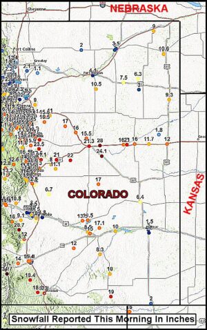
Kansas City, November 8 (World Weather Inc.) – Another impressive storm system predicted by computer weather forecast models days in advance continues to rage in U.S. hard red winter wheat areas. The storm has produced copious amounts of snow in eastern Colorado and moderate to heavy rain in portions of wheat country from the eastern Texas Panhandle and western and central Oklahoma into southwestern Kansas. The snowfall in Colorado has piled up to more than 2 feet closing roads and inducing a stressful and dangerous situation of livestock. The storm will end Saturday.
Excessive Georgia, South Carolina Rain Impact Cotton, Peanuts
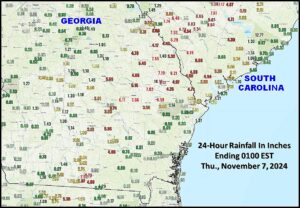
Kansas City, November 7 (World Weather Inc.) – An excessive rain event occurred Wednesday into this morning from the northern part of Florida through south-central and east-central Georgia to central South Carolina. Rain totals were enough to induce flooding and threaten some of the region’s unharvested cotton, soybean and peanut crops. Drier weather is already returning to the region this afternoon and it will continue to dry out over the next couple of days. Flooding will remain into the weekend for some areas.
Weekly Citrus Weather For Tuesday, November 5, 2024
Kansas City, November 5 (World Weather Inc.) – Tropical Storm Rafael is not likely to turn toward Florida citrus areas. A little short term bout of tropical moisture will move through the state’s fruit trees, but no excessive wind or flooding is expected. The environment in Florida should be mostly good as the region continues to clean up and recover from Hurricane Milton. In the meantime, Sao Paulo, Brazil reported some impressive rainfall this past week improving soil moisture and crop development conditions greatly. Another rainy and seasonably warm week of weather lies ahead. In Mexico, seasonal rains continue in decline which is normal. Outside of drought in the northwest the prospects for 2025 crops is not too bad in the northeast and very good in the south. Timely winter rain will be very important for Mexico, though.
Serious Flooding Possible Oklahoma To Missouri
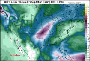
Kansas City, November 1 (World Weather Inc.) – Drought will be dramatically eased and in some cases busted by heavy rain that is expected from parts of Oklahoma through central Missouri to parts of northwestern Illinois. The forecast has not changed much today; however, the potential threat for serious flooding is rising even though the ground is still relatively dry. A close watch on this same area may be needed in the second week of the outlook as additional moisture possibly flows into the region.
Weekly Citrus Weather for October 29, 2024
Kansas City, October 29 (World Weather Inc.) – Florida’s citrus areas were either dry or received limited rain during the past week. The lack of rain was beneficial for producers still assessing damage and cleaning up from Hurricane Milton. Drier than normal weather will persist during the coming week and producers should be able to continue with farming activity and clean-up. Brazil’s citrus areas received rainfall on a frequent basis during the past week with more rain on the way in the coming week. Citrus fruit setting and development conditions will remain favorable. In Mexico, several areas in western and east-central Mexico will receive enough rain to potentially slow harvesting during the coming week.
U.S. Winter 2024-25 To Be Wettest East, NW
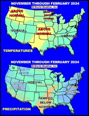
Kansas City, October 28 (World Weather Inc.) – A change in weather is coming for North America over the next several months that will bring on some improvement in precipitation after an unusually dry and warm September and October. The only exception to the recent dry conditions has been the Delta, lowermost Midwest and southeastern states due to Hurricanes Francine and Helene. The first sign of change is coming in November and that will bring some relief to dryness from the southwestern Plains through a part of the central Plains and lower Missouri River Valley to the western Great Lakes region while the southeastern states are still drier than usual. During the winter this will change, though, with the Atlantic Coast States and many areas from the Tennessee River Basin to the northeastern states likely to be a little wetter than usual. A part of the Pacific Northwest and Great Basin will also be wetter biased. Temperatures will average near to above normal.
North America Weather Still Paralleling 1952
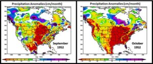
Kansas City, October 25 (World Weather Inc.) – Weather in North America in recent weeks has had a strong parallel to that of 1952. Many forecasters and analysts have attributed the unusually dry weather in North America to La Nina or the transitioning from El Nino to La Nina, but that may not be the case since La Nina has still not evolved and may not, despite the NOAA forecast suggesting that La Nina is still coming. The parallel to 1952 is quite interesting, but it may not last too much longer because of other weather features evolving that will have influence in 2025 that will differ from those of 1953.
Weekly Citrus Weather For Tuesday, October 22, 2024
Kansas City, October 22 (World Weather Inc.) – The extent of the damage due to Hurricane Milton in Florida was still not known and assessments were ongoing. This season’s crop is expected to be one of the smallest in the past few decades and that was before Hurricane Milton. Precipitation will be limited during the coming week, which will be beneficial for clean-up efforts and damage assessments. Brazil’s citrus areas will continue to have several opportunities for seasonal rainfall during the coming week. Flowering and fruit setting conditions will improve, though concerns for a smaller than usual crop for the upcoming season persist. Tropical Storm Nadine brought heavy rain to portions of Veracruz, Puebla, and northeastern Mexico in recent days. Flooding resulted, though citrus damage was suspected of being minimal.
U.S. Hard Red Winter Wheat Rainfall Remains Disappointing
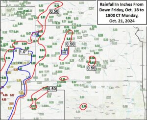
Kansas City, October 21 (World Weather Inc.) – An impressive upper level low pressure center over the southwestern United States is being ejected through the central Plains and will eventually move across the Midwest this week. Even though 1.00 to more than 6.00 inches of rain fell in eastern New Mexico and 1.00 to 3.30 inches occurred in southeastern Colorado, the bulk of hard red winter wheat country has failed to get much relief to drought and/or abnormally dry conditions. Significant rain chances are expected to remain poor for the coming ten days, despite some showers.
Disappointing Drought Relief In U.S. Plains Wheat Areas
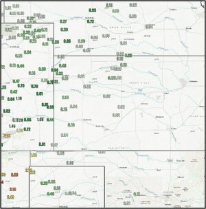
Kansas City, October 20 (World Weather Inc.) – Rain developed as expected in the central and southwestern U.S. Plains during the weekend. The resulting rainfall was, by far, greatest in southeastern Colorado and especially eastern New Mexico, but very little relief from drought occurred in the key wheat production areas of Kansas, Oklahoma or the Texas Panhandle, although showers will develop additionally into these areas Monday.
Central U.S. Strong Wind Speeds To Prevail Into Thursday
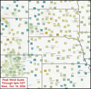
Kansas City, October 16 (World Weather Inc.) – Strong wind speeds have developed across the U.S. Great Plains today and they will prevail through Thursday before finally diminishing. The wind may blow a little dust around in the driest areas and may contribute to limited plant moisture across wheat production areas in the Plains. That makes the Friday through Sunday rain event all the more important.
U.S. Hard Red Winter Wheat Areas To Receive Timely Rain
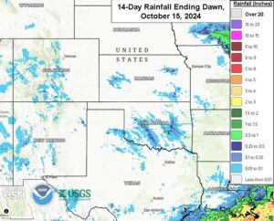
Kansas City, October 16 (World Weather Inc.) – Hard red winter wheat planting continues across the U.S. central and southern Plains. Nebraska and Colorado are almost finished planting while Kansas, Oklahoma, and Texas still have a few weeks more before much of the crop is planted. The main concern remains drought or abnormally dry conditions that are prevalent in much of crop country. The need for rain is high in order to support better establishment, most notably for the driest areas in Oklahoma and neighboring locations. Harvesting of summer crops otherwise advanced with few disruptions in recent weeks as warmer- and drier-than-normal weather took hold of the region. The central and southern Plains will receive much-needed rain Friday through the weekend as a cut-off, upper-level, low-pressure center advances over the region. Drought will be eased and wheat will establish under more favorable conditions. Additional rain will still be needed to support ideal long-term wheat prospects.
Weekly Citrus Weather For Tuesday, October 15, 2024
Kansas City, October 15 (World Weather Inc.) – Damage assessments are still ongoing across Florida as Hurricane Milton devastated the state last week. Damaging winds toppled some trees, damaged limbs, and promoted significant fruit droppage. Although losses are likely, the extent of the loss is not yet known and may not be known for weeks or even months. Drier weather during the coming week will support a better environment for clean-up. In Mexico, late-season monsoonal rain and a weak tropical disturbance will likely slow or delay harvesting and general farming activity. Quality declines will remain a concern due to the sluggish harvest progress. Seasonal rainfall in Brazil will slowly improve flowering and fruit setting conditions.
U.S. Frost, Freezes To Have Minimal Impact On Crops
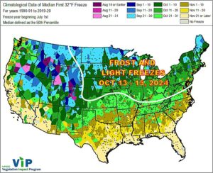
Kansas City, October 10 (World Weather Inc.) – Harvesting of the corn, soybeans, and other summer crops is ongoing across the U.S. Corn and Soybean Belt. While maturation and harvest conditions were generally good in recent weeks, there are still a few soybean and corn fields that may not be fully mature. Temperatures will remain warmer than normal during the next few days and should help maintain a good environment for late-season maturation. A strong cold front will then advance across the Midwest later this weekend and early next week that will increase potentials for frost and light freezes. Crop damage should be minimal as a majority of the corn and soybeans should already be mature. The impact of frost and freezes for any immature crop will be minimal with the biggest risk being blackened soybeans. The cold will not have any major impact on winter wheat. The wheat crop’s biggest threat is due to ongoing dryness and drought will continue to spread and intensify in the Midwest and Great Plains due to the lack of rain.
Hurricane Milton Leaves Florida; Damage Assessment Begins
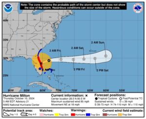
Kansas City, October 10 (World Weather Inc.) – Hurricane Milton left the coast of east-central Florida prior to dawn today and has left behind widespread power outages, considerable tree and structural damage and some significant flooding. The sun was just beginning to rise at the time of this report and visible damage assessments have not yet begun. However, the damage is suspected of being widespread from the heart of central Florida to interior portions of the northeast.
Weekly Citrus Weather For October 8, 2024
Kansas City, October 8 (World Weather Inc.) – Hurricane Milton is the main focus for Florida’s citrus region in the coming days. Polk County (Florida’s largest producer of citrus) and many other counties from Manatee, Sarasota and Hillsborough east northeast to Brevard Country may be most impacted by hurricane or tropical storm force wind speeds. Elevated winds may also impact other citrus areas. Fruit droppage and limb and tree damage are expected with some of the younger trees potentially being uprooted as well. Significant production losses will be possible, most notably in areas within 60 miles of the Interstate Highway Four. Next season’s crop could also be impacted depending on the extent of the damage. Mexico’s citrus yields will remain mostly unchanged. Brazil’s citrus region will finally receive rain that will support a better environment for flowering.
U.S. Drought Breeds Excessive Wind, Wild Temperature Swings
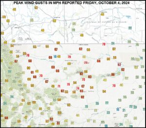
Kansas City, October 7 (World Weather Inc.) – Returning drought to the heart of North America this autumn has resulted in the persistence of very warm, summer-like, temperatures. Relative humidity has plummeted in most of the region from the western Midwest through the Great Plains to the Pacific Coast States. Low humidity is normal in a drought and allows wild temperature swings to occur. The faster the temperatures change the higher wind speeds become. This past weekend’s windstorm in the northern Plains was indicative of this as a cold airmass briefly passed through some of the drought region.
La Nina Not To Be Blamed For World Weather Anomalies
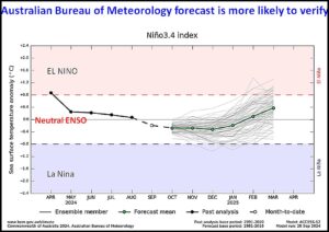
Kansas City, October 4 (World Weather Inc.) – Dryness in the central and western United States, China’s Yangtze River Basin, areas from eastern Ukraine to Kazakhstan, South America and Australia cannot and should not be attributed to La Nina because it does not exist. Some of the dryness might be attributed to the tendency to develop toward La Nina, but it does not look like a full blown La Nina event is going to evolve. Because of that some of the world’s dryness cannot be attributed to that phenomenon. The U.S. National Oceanic and Atmospheric Administration’s (NOAA) ENSO forecast model continues to predict a La Nin event is imminent as it has all year long, but it has not evolved and World Weather, Inc. is highly skeptical that it will evolve anytime in the remainder of this calendar year.
Dry Conditions to Continue in U.S. Pacific Northwest
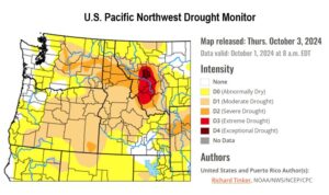
Kansas City, October 4 (World Weather Inc.) – Recent dry weather in the U.S. Pacific Northwest crop region has allowed for ideal fieldwork conditions; however, drought is gradually intensifying across the crop region and reservoir levels are being depleted in the Yakima and Umatilla Basins. In the next 7-days, minimal rainfall between trace amounts and 0.20 inch are expected in Washington and northern Oregon with dry conditions persisting elsewhere. More precipitation will be needed in the coming weeks to reduce drought conditions, improve soil moisture, and to support emergence and development of winter wheat.
U.S. Plains Wheat, Livestock Face A very Dry Month
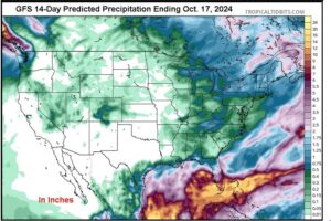
Kansas City, October 2 (World Weather Inc.) – Beneficial rain fell across a part of the central U.S. Plains during mid-September bolstering soil moisture for improved early season wheat planting and establishment conditions. Grazing grass conditions also improved; however, temperatures were quite warm in late September and precipitation diminished leading to rapid drying. Today’s moisture profile is quite poor and there is no potential for significant rain through the next two weeks. Rainfall in the second half of the month will likely be below normal as well unless tropical moisture flows into the region.
Weekly Citrus Weather For October 1, 2024
Kansas City, October 1 (World Weather Inc.) – Although Hurricane Helene did not make direct landfall over Florida’s citrus country, several areas near and along the Gulf of Mexico received several inches of rain during the past week. Flooding was possible in the wettest pockets, though no damage to citrus fruit or trees was suspected. The main production areas will receive additional rain during the coming week that will maintain a good outlook for the citrus. In Mexico, Tropical Storm John brought torrential rain to Guerrero and several neighboring areas in Colima, Michoacan, and Oaxaca early last week. Severe flooding and landslides were noted, which may have damaged or destroyed some fruit and trees. Flooding and standing water will remain a concern in the coming days as frequent rainfall persists. In Brazil, the main citrus areas will remain warmer and drier biased in the coming week. Flowering conditions will remain less than favorable to poor.
U.S. Southeast, Ohio River Valley To Face Impacts From Helene
Kansas City, September 27 (World Weather Inc.) – Torrential rain and damaging winds lashed portions of the U.S. southeast during the past two days as Hurricane Helene approached and eventually made landfall. Severe flooding was noted in portions of northern Florida, Georgia, the Carolinas, and neighboring locations at a time when many producers were harvesting or getting ready for the harvest. Significant damage or losses are expected for some of the peanut and other oilseeds, coarse grain, cotton, other crops produced in the southeast this time of year. Fieldwork will be delayed for several days or even weeks as many areas receive additional rain today and flood water recedes into next week. Most of the lower eastern Midwest will also be impacted by rain associated from Helene during the next several days resulting in harvest delays. Other U.S. crop areas will be drier biased-for nearly 10 days favoring crop maturation and harvesting.
Hurricane Helene Greatest Impact North Florida, East Georgia
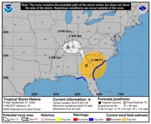
Kansas City, September 27 (World Weather Inc.) – Hurricane Helene moved into Florida from in the northeast part of the Apalachee Bay with 140 mph sustained wind speeds. The storm likely induced devastation from its storm surge, incredible wind speeds and extensive flooding from northern Florida northward into eastern Georgia, but the damage extended farther to the north reaching up along the southeastward facing slopes of the southern Appalachian Mountains in the Carolinas as well where torrential two-day rain totals of 12 to nearly 19 inches was reported. The only good news for the storm from an agricultural perspective is a lower impact on cotton production areas in southwestern Georgia and immediate neighboring areas as the storm’s path veered to the east after coming inland. Damage assessments are only just beginning and will continue for many days.
Southeast U.S. Rainfall From Helene Through 10am CDT
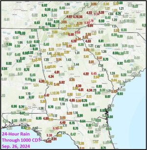
Kansas City, September 26 (World Weather Inc.) – Hurricane Helene was still 255 miles from Tampa Florida and 290 miles south of Apalachicola at 10am CDT today, but rain has already been falling since Wednesday from Florida to the southern Appalachian Mountains. Flood warnings are already in effect and the situation is expected to get worse as the storm comes ashore tonight and reaches into Tennessee Friday.
Tropical Storm Isaac In Atlantic Ocean Poses No Land Threat
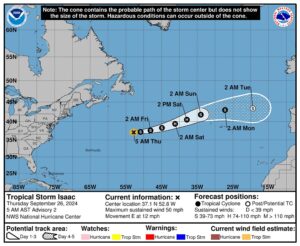
Kansas City, September 26 (World Weather Inc.) – Tropical Storm Isaac evolved in the central Atlantic Ocean overnight, but was expected to move east northeasterly during the next few days. The system will move away from North America and will become a hurricane briefly this weekend. The system will then weaken as it moves toward Western Europe with some gradual translation into a mid-latitude storm system over time.
Hurricane Helene’s Impact May Be Like That of Michael In 2018
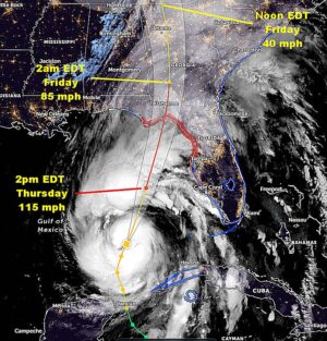
Kansas City, September 26 (World Weather Inc.) – Hurricane Helene will be barreling its way toward the southeastern United States today with landfall this evening in the northern Apalachee Bay south of Tallahassee, Florida. Landfall will occur as a Category Three storm with devastating impacts from the entire Apalachee Bay area northward into southern Georgia. Crop and property damage will likely be similar to that of Hurricane Michael that impacted much of the same region in early October 2018. Catastrophic damage will occur within 120 miles of the storm center, although the worst conditions will extend about 80 miles northeast of where the storm center reaches land.
Weekly Citrus Weather For Tuesday, September 24, 2024
Kansas City, September 24 (World Weather Inc.) – Florida citrus conditions remain favorable due to rain and warm weather during the past week. Tropical Storm Helene will rapidly advance across the Gulf of Mexico tonight and Wednesday while intensifying rapidly. Landfall is expected in the northern Apalachee Bay area of Florida. A direct hit on citrus country is not expected, though some rain will spread across the main production areas. Localized flooding will be the main concern near the Gulf of Mexico coast, though citrus impacts should be minimal. In Mexico, Tropical Storm John will meander along the western Mexico coastline during the next several days. Torrential rain is slated for southern Oaxaca, southeastern Guerrero and neighboring locations with upwards of 30.00 inches of rain possible. Flooding will be the primary issue and most citrus trees will not be impacted by the excessive moisture. Brazil’s citrus areas will remain hot and dry in the coming week. The heat may hurt citrus flowers.
U.S. Midwest Rain Will Impact Harvest Rates
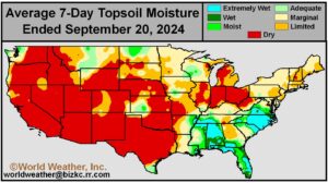
Kansas City, September 20 (World Weather Inc.) – Corn and soybean harvesting is underway in portions of the U.S. Midwest. Spotty rain may have impacted early-season harvesting in portions of crop country during the past week, though rainfall was too light to keep producers out of the fields for an extended period of time. Disturbances will promote more widespread and significant rain through the end of next week for much of the Corn and Soybean Belt outside the Dakotas, Minnesota, and immediate neighboring locations. Harvesting and general fieldwork will likely be slowed or delayed, most notably in the wettest areas of Illinois, Indiana, and neighboring locations. The moisture will be beneficial for future wheat planting, emergence and establishment.
La Nina Is No Scapegoat For Anomalous World Weather
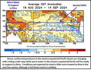
Kansas City, September 18 (World Weather Inc.) – The news media has recently been swamped by articles about La Nina and how it has impacted world weather. The articles are all quite entertaining and sometimes downright alarming, but the truth about world weather today is that La Nina does not exist. La Nina events require anomalously cool ocean surface water across the eastern equatorial Pacific Ocean to change world weather patterns and the anomalies are certainly not there – at least not today. Computer forecast modeling is not in agreement over the future for ENSO (El Nino Southern Oscillation) events with the U.S. National Oceanic and Atmospheric Administration (NOAA) suggesting La Nina is imminent while the Australian Bureau of Meteorology and the New Zealand weather service suggest La Nina may not be coming.
Weekly Citrus Weather For September 17, 2024
Kansas City, September 17 (World Weather Inc.) – Florida’s citrus region continued to see a good environment for tree and fruit development due to frequent rainfall and irrigation. With more rain on the way during the coming week, the outlook will remain relatively good for much of the crop. Mexico’s citrus areas received frequent rainfall during the past week as well. The rain slowed harvesting and likely improved some of late season fruit quality in the wettest locations in Veracruz. The main production areas will continue to receive rain on a frequent basis during the coming week. Harvesting will advance slowly in areas that get frequent rain, but much of the harvest occurs in the dry season and not now. Brazil’s main citrus areas will remain drier and warmer biased during the coming week. The environment will be less than favorable for the early-flowering citrus.
U.S. Hard Red Winter Wheat Country Will Receive Some Rain
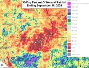
Kansas City, September 16 (World Weather Inc.) – Hard red winter wheat planting is underway in portions of the U.S. central and southern Plains. Drought or abnormally dry conditions were prevalent for much of crop country this past week and the need for rain is increasing. Crops may establish unevenly or poorly in coming weeks if dryness intensifies, most notably in the rain-fed areas. The region will have opportunities for erratic rainfall and thunderstorms this week as two disturbances track across central North America. The main production areas will receive enough rain to marginally bolster topsoil moisture that should improve short-term establishment. Much more rain will still be needed to ensure ideal long-term crop prospects.
Potential Tropical Cyclone Lurks Off U.S. Carolina Coast
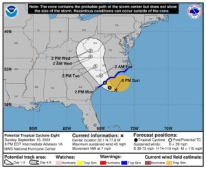
Kansas City, September 14 (World Weather Inc.) – A potential tropical cyclone was located nearly 140 miles from the Charleston, S.C. coast at 2000 EDT today (0001 GMT Monday) The system was expected to drift inland through South Carolina to western North Carolina Monday into Wednesday while diminishing to a remnant low pressure center. The system may become a named storm overnight, but its only serious threat to the region may be local flooding because of potential heavy rainfall
U.S. Southeast Harvest To Be Impacted By Remnants Of Francine
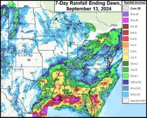
Kansas City, September 13 (World Weather Inc.) – Crops are maturing or being harvested in several portions of the U.S. Southeast. Hurricane Francine recently moved through the Delta and dissipated, although its remnants will impact the southeastern states during the next few days. Waves of rain will likely slow or delay maturation and harvesting in portions of the U.S. southeast and northern Delta with minor quality declines also possible. The Midwest and Plains will otherwise experience more favorable conditions for aggressive maturation and harvesting during the coming week. Rainfall will be limited and should not significantly slow the harvest and general fieldwork.
WORLD SUGAR WEATHER: Brazil, Southern India Drying Out
Kansas City – September 12 (World Weather, Inc.) – Sugar production areas around the world are dealing with some moisture shortages that could cut into production during the coming year. Brazil soil moisture is quite limited, although the rainy season has not begun yet and there is plenty of time for improved rainfall. Southern and west-central India has recently begun to dry down and that, too, may have the market’s attention for a little while. Southern Indonesia is also experiencing some less than usual rain along with Ukraine and portions of Russia’s beet production area. Thailand has also had some stressful weather at times this year.
Atlantic Tropical Depression Seven Not A Threat To Land
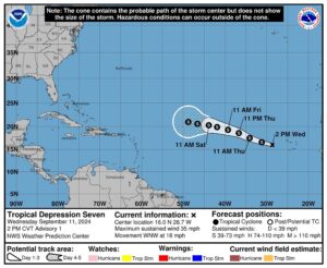
Kansas City, September 11 (World Weather Inc.) – Tropical Depression Seven formed over open water in the eastern tropical Atlantic Ocean today and was expected to become a tropical storm soon. The movement of this storm will be west northwesterly over the next few days keeping the system over open water. Eventually, a turn to the north and/or the northeast is expected and will keep the system out over open water through most of its lifetime.
Hurricane Francine To Move Inland This Evening In Louisiana
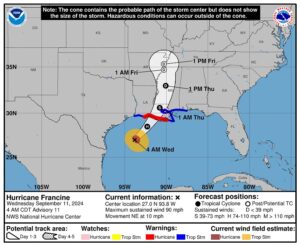
Kansas City, September 11 (World Weather Inc.) – Hurricane Francine was producing widespread rain along the Louisiana coast this morning, although the precipitation has been light so far. Wind speeds have also been light staying under 25 mph in most areas. However, the center of the storm was expected inland this evening passing to the south southwest of Morgan City. The storm center will pass to the west of New Orleans and it may come ashore with sustained wind speeds near or above 100 mph. Damage to sugarcane is quite likely along with serious beach erosion and both coastal flood and wind damage. The storm will then move up through the eastern Delta where some heavy rain and flooding is expected along with tropical storm force wind.
U.S. Midwest Weather Will Favor Maturation, Early Harvesting
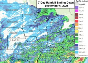
Kansas City, September 6 (World Weather Inc.) – Rainfall was limited across the U.S. Corn and Soybean Belt during the past week. The environment was favorable for the more advanced crops that are maturing and getting ready for harvest. Late-season development conditions remained generally favorable as well despite the lack of rain, although crops in the Ohio River Valley continued stressed due to dryness. Production potentials remain favorable across the region with a bumper soybean crop still expected. Rainfall will be limited across the Midwest through the end of next week with periods of warmer than normal weather expected in the western Corn Belt. The environment will remain favorable for aggressive maturation and early-season harvesting.
Upper U.S. Midwest Cold To Have Low Impact On Crops
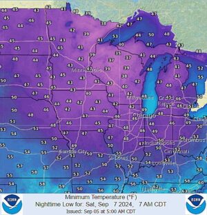
Kansas City, September 5 (World Weather Inc.) – Cold air continues to push into the upper Midwest today from Canada. It will be the coldest airmass of the season and it should settle into Wisconsin Minnesota and upper Michigan Saturday morning. A part of northeastern Iowa and northwestern Illinois will also feel the coolness as will all other areas in the Midwest later in the weekend. Soft frost is expected in soybean and corn production areas of Wisconsin and a few areas in eastern and northern Minnesota as well as upper Michigan. The impact on crops is expected to be low unless the temperatures get colder than expected. There is potential for a pocket or two of near freezing temperatures in Wisconsin.
Weekly Citrus Weather For September 3, 2024
Kansas City, September 3 (World Weather Inc.) – Florida’s citrus areas received enough rain to maintain a good environment for ongoing tree and fruit development during the past week. With more rain on the way during the next seven days, the outlook for the citrus will remain favorable. In Mexico, rain was scattered across the main citrus areas during the past week. More widespread and significant rain is expected during the coming week, which will be beneficial for short-term development. Production potentials are still lower than usual for this season due to the adverse conditions earlier in the year. Brazil’s citrus areas were mostly dry during the past week and will remain mostly dry during the next seven days. Harvesting will advance swiftly.
Much Needed Rain for Texas and U.S. Delta to Occur
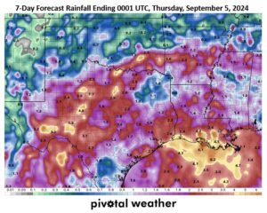
Kansas City, August 30 (World Weather Inc.) – The southern U.S. has struggled to receive adequate moisture in the past month as less than 25% of normal rain has occurred in much of Texas, Louisiana, and Mississippi. Temperatures have also been very warm to hot at times resulting in short to very short soil moisture and general crop and livestock stress. In the next 7-days however, between 1.00 and 2.60 inches of total rain is expected from a few waves of showers and thunderstorms. Locally heavier totals in excess of 3.00 inches are likely in some areas. These amounts will benefit sorghum that is continuing to develop in much of the region and late double cropped soybeans in the Delta, but less beneficial to corn as the crop is largely mature. Some quality reduction or damage to cotton is possible in portions of Louisiana and Mississippi where bolls continue to open.
U.S. Midwest Spotty Rain Beneficial For Late-Season Growth
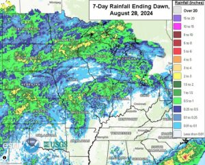
Kansas City, August 28 (World Weather Inc.) – Rainfall varied across the U.S. Midwest during the past week with much of the Ohio River Basin and portions of Iowa and southern Wisconsin and Minnesota receiving little to no rain. Other locations saw a good mix of rain and sunshine. Corn and soybean conditions remained generally favorable. However, some corn deterioration was noted in portions of Ohio and neighboring locations as the ground dried down. Rain and thunderstorms will evolve across the Midwest during the next few days before drier weather evolves later this weekend into the middle of next week. The rain will help maintain relatively favorable conditions for late-season corn and soybean growth. Early-season maturation conditions will also improve or remain favorable across the region. Yields are expected to be favorable this season with a bumper soybean crop possible.
Weekly Citrus Weather For August 27, 2024
Kansas City, August 27 (World Weather Inc.) – Florida’s citrus areas received rain on a frequent basis during the past week. The region will trend slightly drier than normal during the coming week, though most locations will have ample moisture to maintain aggressive growth. In Mexico, the northeastern production areas again received little to no rain while east-central and western Mexico received rain on a frequent basis. Monsoonal rainfall will evolve across the country during the coming week and will start to improve the moisture profile in the northeast corner of the country. Production potentials remain lower than usual as a whole for Mexico due to adverse conditions over the growing season. Brazil’s citrus areas will be seasonably dry during the coming week. Harvesting and general farming activity will advance with few disruptions.
West Texas Advertised Soaking Rain To Have Mixed Impact
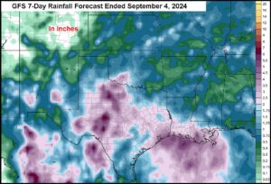
Kansas City, August 27 (World Weather Inc.) – West Texas corn, sorghum, cotton and peanut production areas may experience the single greatest week of rain since the one ending June 12 during the next seven days. The stage is being set for an impressive amount of rain, but there is still time for the pattern to change. If the setup for multiple days of rain verifies there will be a mixed influence on crops in the region. The greatest benefit from a general rain might be the bolstering of soil moisture and water supply for use by winter crops and the boost in water supply for 2025, although much more rain will still be needed. For summer 2024 crops, the rain will come too late to change production in a big manner. Autumn grazing conditions will improve and immature irrigated crops may experience some quality improvement and a slight lift in yield. Cooler temperatures will also be welcome.
Excessive Southern U.S. Plains Heat To Expand North, East
Kansas City, August 22 (World Weather Inc.) – A long week of excessive heat has occurred in the southern half of the U.S. Plains this week. Daily high temperatures of 95 to 110 Fahrenheit occurred nearly every day since the end of last week in Texas and Oklahoma with extremes of 111 to 117 in southern Oklahoma and areas south into central Texas. The heat will remain in the southern Plains today and Friday, but a building ridge of high pressure aloft this weekend and early next week will expand the heat into the central Plains and the southwestern Corn and Soybean Belt before moderating and spreading to the east through the lower Midwest, Delta and Tennessee River Basin. The heat and high relative humidity will induce a very stressful environment for all living things. Some partial relief is expected next week with scattered rain, but Texas to the southeastern states may stay dry into the U.S. Labor Day holiday weekend.
Weekly Citrus Weather For August 20, 2024
Kansas City, August 20 (World Weather Inc.) – Florida’s citrus areas again received timely rain during the past week. With more rain on the way during the coming week, rainfall will help keep soil moisture and water storage at favorable levels. Citrus development conditions will remain good. In Mexico, monsoonal rain continued on a frequent basis for the east-central and western production areas. Much of citrus country will have opportunities for rain during the coming week, even the driest areas in the northeast. However, yield potentials will remain lower than usual due to adverse conditions earlier this growing season. A frontal boundary will bring some rain to Sao Paulo and southwestern Minas Gerais, Brazil late Friday and this weekend. No major delays are expected and dry weather will support better harvest conditions most other days during the coming week.
Excessive Heat South U.S. Plains; SW CIS Still Dry, Warm Too
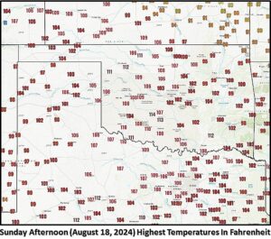
Kansas City, August 19 (World Weather Inc.) – Weekend weather brought excessive heat to the southern U.S. Plains with highest temperatures of 110 to 116 Fahrenheit. No rain fell in the region either. In the meantime, very warm temperatures and no rain continued in southeastern Europe southwestern Russia where the heat and dryness will persist this week. Russia’s New Lands will remain mild to cool and wet for at least one more week.
U.S. South Plains Heat, Dryness To Leave Early Wheat Areas Dry
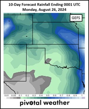
Kansas City, August 16 (World Weather Inc.) – Early season winter wheat planting is due to begin in the first week of September in the southwestern U.S. Plains. A bout of hot, dry, weather dominating the second half of August may leave the environment a little unfavorable for early seeding unless early September rainfall is cooler and wetter. In the meantime, daily temperatures in the 90s to 110 degrees Fahrenheit and no rainfall of significance will stress summer crops and livestock.
World Cotton Weather For August 14, 2024
Kansas City, August 14 (World Weather Inc.) – Weather conditions in most of the cotton production areas around the world are largely good which may help explain the commodity market trades in recent weeks. India and Pakistan weather has improved after some concern over early season cotton that was subjected to some incredible heat earlier this year. Xinjiang, China has had weather conditions good enough to support high yields and the outlook in the United States has been a little more mixed. Harvest conditions in southern Texas have been good while boll sizes in California and Arizona may be down a bit because of this year’s excessive heat. West Texas dryland crops in the southwest never got off to a good start and may have been largely written off. Hurricane Debby was not very kind to production areas from northeastern Florida to North Carolina, but the storm’s damage did miss some very important acreage in Georgia and Alabama.
Weekly Citrus Weather For August 13, 2024
Kansas City, August 13 (World Weather Inc.) – Florida saw normal weather return during the past week after Hurricane Debby brought heavy rain to portions of citrus country. Leftover moisture from Debby may have limited farming activity in the wettest locations. Citrus development conditions were otherwise favorable. Drier-than-normal weather is slated for much of citrus country during the coming week. Areas that are still excessively wet will welcome the drying trend. In Mexico, east-central and western Mexico saw a good mix of rain and sunshine this past week while northeastern Mexico was dry and this pattern will continue. Overall, Mexico’s citrus production potential remains less than favorable due to adverse conditions earlier this year. Brazil’s citrus areas received timely rain during the past week and seasonally dry weather will return during the coming week.
U.S. Midwest, Northern Plains To See Rain Return This Week
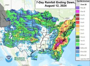
Kansas City, August 12 (World Weather Inc.) – Outside portions of the Atlantic Coast States impacted by Hurricane Debby, aggressive drying was noted in a large portion of the U.S. agricultural belt during the past week. Rainfall was limited outside portions of the Upper Midwest. Temperatures were also warmer biased in portions of the Plains, which accelerated drying. The Midwest still had some moisture to support new growth despite the drying trend. Rain will return for much of the Midwest and northern Plains this week that should maintain a good environment for the crops produced this time of year. Many areas in the central Plains will also receive timely rain while the southern Plains are drier biased. The Delta, however, may continue drier biased, despite some rain.
U.S. Plains Heat To Return After Aug. 16; Lunar Cycle Verifies
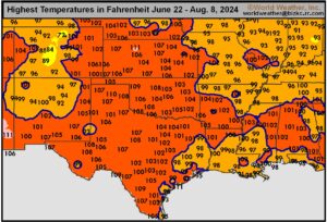
Kansas City, August 9 (World Weather Inc.) – Summer weather in the U.S. central and southern Plains has been very warm to hot this year just like some of the temperatures in the far western United States. The number of days with 100-degree heat has been well above average from the central and southwestern Plains to the Pacific Coast. Some climate enthusiasts want to make the summer’s heatwave a climate change issue, but World Weather, Inc. reminds its readers of our winter temperature study that clearly showed a link between the lunar cycle for this year and an unusually high number of 100-degree temperature days that occurred in 2006, 1988, 1970, 1952, 1934 and to a lesser degree 1916 in the Great Plains and some immediate neighboring areas. The Great Plains heat has been abating this week, but it will return again August 16.
Weekly Citrus Weather for August 6, 2024
Kansas City, August 6 (World Weather Inc.) – Hurricane Debby brought torrential rain to several counties along the Gulf of Mexico Coast of Florida in recent days. Severe flooding was noted, though citrus damage was initially suspected of being minimal. Other locations received enough rain to maintain a good environment for crops. Precipitation will be a little lower than usual during the coming week. Flooding will slowly decrease in the wettest locations. Northeastern Mexico was mostly dry during the past week while the remaining citrus areas saw a good mix of rain and sunshine. A similar weather pattern will occur during the coming week. Brazil’s citrus areas will have opportunities for mostly light rain later this week, though no major harvest delays are expected.
Debby Brings Copious Rainfall, Flooding To Northern Florida
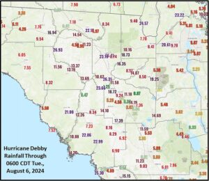
Kansas City, August 6 (World Weather Inc.) – Hurricane Debby became a tropical storm quickly during the morning Monday after slamming into the northern Apalachee Bay coast producing wind gusts to 98 mph. During the day Monday, incredible amounts of rain fell across the interior northeast and north-central parts of Florida with totals ranging from 10.00 to more than 26.00 inches. Such rains occur more often in China, but not in the United States. Similar amounts are anticipated in South Carolina over the next few days with some lower coastal areas already reporting more than 11.00 inches through dawn today. Flooding is going to destroy property and agriculture. Florida’s rainfall is over, but the Carolinas will deal with it for a few more days and a similar impact is likely.
Tropical Storm Debby To Flood Parts Of Georgia, The Carolinas
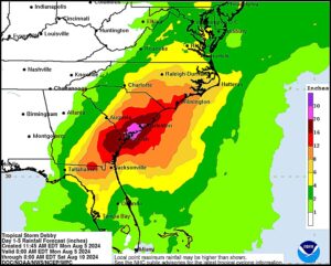
Kansas City, August 5 (World Weather Inc.) – Hurricane Debby already promoted heavy rainfall along the Gulf Coast of the Florida peninsula over the weekend. Flooding was noted in many areas as the disturbance approached the state and eventually made landfall over the Big Bend region of Apalachee Bay this morning. Debby has already been downgraded to tropical storm status and will track from northern Florida into Georgia today. The disturbance will meander around Georgia, move back over the western Atlantic Ocean briefly and then back into the U.S. southeast later this week with torrential rain slated for portions of Georgia, South Carolina, and eastern North Carolina. Severe flooding is the main concern with portions of southeastern Georgia and southern South Carolina potentially receiving more than a foot of rain. Property damage and damage to coarse grain, oilseed, cotton, and other crops is likely, especially those in low-lying areas.
U.S. Southeast Will Be Impacted By Tropical Disturbance
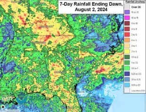
Kansas City, August 2 (World Weather Inc.) – Potential Tropical Depression Four was located over southeastern Cuba earlier this morning. The disturbance will track across the country today before intensifying as it reaches the southeastern Gulf of Mexico Saturday. The disturbance will then shift north-northeasterly across Florida late this weekend and eventually along the Atlantic coastline early next week. Heavy rain will evolve from southeastern Georgia into eastern sections of the Carolinas. Flooding will be possible; although, the most damaging conditions are expected outside the major production areas. The rain will otherwise be welcome for eastern South Carolina as much of the region is in drought. In the meantime, the remaining locations in the U.S. southeast will trend drier than normal through the end of next week. Dryness will spread and intensify and may impact development conditions.
U.S. Midwest To Dry; Timely Rain Needed Later This Month
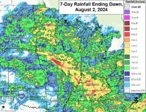
Kansas City, August 2 (World Weather Inc.) – Rainfall during the past week was enough to maintain a good environment for the corn and soybeans across the Midwest. Production potentials remain favorable despite some areas in the eastern Corn Belt remaining abnormally dry. The Upper Midwest will see a good mix of rain and sunshine that will maintain aggressive growth through the end of next week. Other production areas will trend drier than normal with periods of slightly warmer than normal weather. Net drying is expected, though most locations will have enough moisture to support new growth. Precipitation potentials will likely increase during the second week of the outlook and should help reverse the drying that occurs during the first week.
August U.S. Weather Driest In Delta, SW Corn And Soybean Belt
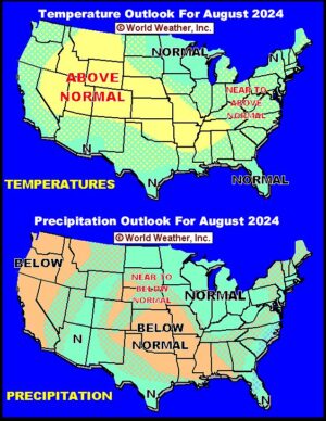
Kansas City, August 2 (World Weather Inc.) – U.S. June/July weather this year was most like that of 2016 which was another year in which El Nino conditions in the first quarter of the year gave way to La Nina conditions during the late summer. However, La Nina is not expected to evolve in the next few weeks and that may end the parallel to 2016. August 2024 is expected to be drier biased in the Delta, southwestern Corn and Soybean production areas and in the southern Great Plains as well as in the far western United States. The heart of the Midwest should see more normal precipitation and much of the nation will be warmer biased except for ten days beginning next week at which time the north-central states will be cooler than usual.
Weekly Citrus Weather For July 30, 2024
Kansas City, July 30 (World Weather Inc.) – Florida’s citrus region received rain on a frequent basis during the past week. The rain was enough to keep soil moisture rated adequately. Citrus conditions remain favorable. Seasonal rainfall will continue on a frequent basis during the coming week, even with the potential development of a tropical disturbance near Florida later this weekend and early next week. Even if the disturbance does verify, impacts for citrus country will be minimal. Mexico’s citrus areas received rain on a frequent basis during the past week as well. Northeastern Mexico will trend drier than normal during the coming week and will dry down significantly. Other locations will see a good mix of monsoonal rain and sunshine. Yield potentials remain lower than usual for the upcoming season. Brazil’s citrus areas will again be mostly dry during the coming week. Harvesting and general fieldwork will advance swiftly.
Returning 45-Day Pattern To Keep North America Ridge West
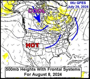
Kansas City, July 29 (World Weather Inc.) – Weekend computer weather forecast models suddenly returned cooler than usual air to the central parts of North America during the second week of August. This is assumed to be the debut of the returning 45-day cool cycle that World Weather, Inc. has been tracking since last October. The cooler air will not last as long as it has in the past because it is the middle of summer and there is plenty of heat in portions of North America to moderate the shots of coolness. However, what the pattern is likely to do is to help keep the North America ridge of high pressure over the west and reduces the potential for the ridge to come into the heart of the Midwest for any great length of time.
U.S. Midwest Rain Will Maintain Good Corn, Soybean Conditions
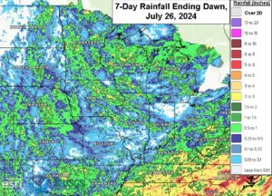
Kansas City, July 26 (World Weather Inc.) – Rain was erratically distributed across the U.S Midwest during the past week. Several locations in Indiana, southern Illinois, northwestern Ohio, and neighboring locations were dry or received limited rainfall. Other locations received enough rain to limit drying. Corn and soybean conditions remain relatively good, even in areas that were mostly dry in recent days. A high-pressure ridge will meander over central North America through the end of next week and will limit rainfall for eastern Nebraska, western Iowa, and southeastern South Dakota. These areas will dry down significantly and the need for rain will increase. Disturbances will otherwise promote erratic rainfall for the remaining production areas that will help keep soil moisture near current levels. Corn and soybean conditions should remain relatively good.
Weekly Citrus Weather for July 23, 2024
Kansas City, July 23 (World Weather Inc.) – Seasonal rainfall was noted across the main citrus areas of Florida during the past week. The environment remained generally favorable for aggressive citrus growth. Although scattered showers and thunderstorms will continue on a frequent basis during the coming week, much of citrus country will trend drier than normal. The need for irrigation may increase in areas that dry down significantly. Mexico’s citrus areas received varying amounts of rain during the past week. Moisture from the Gulf of Mexico will funnel into the country during the coming week, which will enhance rainfall for several production areas. Development conditions will slowly improve. However, additional rain will be needed to completely erase drought. In Brazil, the main citrus areas were mostly dry during the past week. Dry or mostly dry weather will persist during the coming week and harvesting will continue with few disruptions.
Unusually Cool U.S. Air Mass To Break Down Later In July
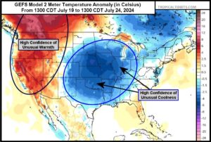
Kansas City, July 19 (World Weather Inc.) – A large, unusually cool air mass has moved down into the central U.S. crop regions in what is typically the hottest time of the year for much of this area. The cool air is mostly beneficial for regions such as the Corn Belt, Delta, West Texas, and Hard Red Winter Wheat Region due to the lack of crop and livestock stress. A weak upper-level weather disturbance will also be slowly moving through the central U.S. this weekend into next week providing some needed rainfall. Warmer air will eventually be needed again to help accelerate crop development, especially for soybeans and should come later this month. Meanwhile, unusual heat in the western Canada Prairies and far western U.S. continues to be an issue.
Weekly Citrus Weather For July 16, 2024
Kansas City, July 16 (World Weather Inc.) – Rain, irrigation, and warm daytime temperatures continued to promote a good environment for Florida citrus during the past week. Daily showers and thunderstorms will continue for Florida during the coming week that will help maintain a good environment for aggressive citrus growth. Mexico’s main citrus areas received rain on a frequent basis during the past week. Citrus conditions continue to improve across the country. Many areas in northeastern Mexico will trend drier than normal during the coming week and will dry down. The need for rain will increase later this month and early August. Other locations in Mexico will receive rain on a frequent basis, which will maintain aggressive citrus growth. Some of Brazil’s citrus areas received enough rain to impact harvest rates during the past week. Mostly dry weather is slated for the region during the coming week. Harvesting will advance with few disruptions.
Southeast U.S. To See Dryness Relief
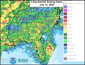
Kansas City, July 12 (World Weather Inc.) – Conditions have started to improve for the U.S. southeastern states. Waves of rain helped improve soil moisture during the past week, though drought or abnormally dry conditions remain prevalent in the main production areas. Virginia and the Carolinas will see periods of significant rain through the end of the weekend that will further improve the moisture profile. Other production areas in the southeastern states will see a good mix of rain and sunshine through the end of next week. Long-term crop conditions will improve or remain favorable in areas that were previously struggling with dryness earlier this season. Corn prospects remain less than favorable in North Carolina due to the poor growing conditions earlier this year.
La Nina Unlikely To Influence Northern Hemisphere Summer
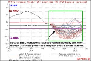
Kansas City, July 11 (World Weather Inc.) – La Nina is no longer expected to have an influence on Northern Hemisphere weather during the current summer season. The latest data clearly shows no advancement in the evolution of ENSO toward La Nina recently nor is there much reason to see significant progression toward that end in the next few weeks. The summer crop growing regions in the Northern Hemisphere are no longer expected to be influenced by La Nina due to its slow evolution and that leaves the door open for other weather patterns to dominate the atmosphere. So far, those “other” patterns do not look too anomalous in major agricultural areas implying a normal production year is at hand.
Weekly Citrus Weather for July 9, 2024
Kansas City, July 9 (World Weather Inc.) – Florida’s main citrus areas received rain on a frequent basis during the past week similar to that of recent past weeks. The rain combined with irrigation continued to support aggressive growth. The region will again have several opportunities for rain during the coming week, though rain totals will trend a little lower than normal as a drier airmass advances over the state. Mexico’s citrus areas saw a good mix of monsoonal rain and sunshine during the past week. Additional rain is slated for the main citrus areas during the coming week and will support improving conditions for fruit production tree growth. Harvesting in Brazil’s citrus areas is ongoing despite some rain in southern Sao Paulo. Rainfall during the next few days may again slow the harvest in southern Sao Paulo.
Hurricane Beryl’s Rainfall Since Sunday And The Outlook
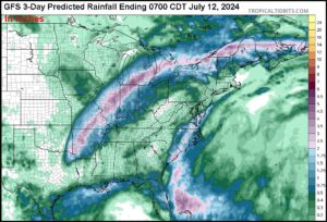
Kansas City, July 9 (World Weather, Inc.) – Hurricane Beryl produced some significant rain from the upper Texas coast through eastern Texas, including the Houston area Sunday into Monday. The storm was downgraded to depression status late Monday and its heavy rain was reduced as it moved northeast toward the Midwest. The storm will have a track record of inducing heavy rain and some flooding, but the impact on agriculture is expected to be quite low.
Remnants Of Hurricane Beryl To Change Midwest Weather
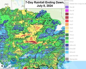
Kansas City, July 8 (World Weather Inc.) – Hurricane Beryl moved into the upper Texas coast this morning and over the next few days the remnants of this storm will reshape the rainfall biases across the U.S. Midwest corn and soybean production areas. The storm will first bring some welcome moisture to the eastern Midwest where rainfall has been a little lackluster at times in the recent weeks. The storm’s presence over the eastern U.S. while a massive heat ridge remains over the western U.S. will lead to a broad trough of low pressure being over the Plains and Midwest that promises to reduce rain in the western Midwest and central through northern Plains. These changes may last long enough to remove some of the surplus moisture from the northwestern Corn Belt while maintaining a good environment for summer crops in the remainder of the region. The favorable weather bias has not helped market trade today which was selling off hard on the good production outlook.
Hurricane Beryl Reaches Texas; Low Impact On Agriculture
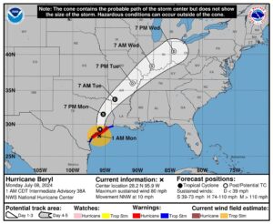
Kansas City, July 8 (World Weather Inc.) – Hurricane Beryl has reached the upper Texas coast near Matagorda, Texas at 0400 CDT today. The storm came ashore as a Category One Hurricane producing sustained wind speeds of 80 mph and some flooding rain along with a notable storm surge. The storm and its remnants will move from eastern Texas through Arkansas by Tuesday evening and then to Ohio by Wednesday evening. Agricultural damage potential from the storm has been greatly reduced by the adjusted storm path since Friday when it looked like the system would impact South Texas.
Western North America Heatwave To Have Many Impacts
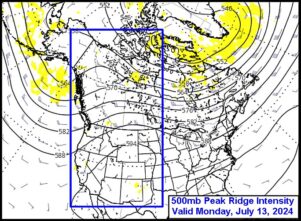
Kansas City, July 5 (World Weather Inc.) – An impressive ridge of high pressure already over the western United States will intensify and drift to the east over the coming week. The system’s intensity and slow movement promises to produce a number of impacts from reduced milk production to strong cooling fuel demand. Dryland spring and summer crops will be seriously threatened from the U.S. Pacific Northwest into the northwestern Great Plains and the southwestern Canada Prairies where in a few days the ground could go from favorably moist to quite dry raising worry over crop production potentials.
Weekly Citrus Weather for July 2, 2024
Kansas City, July 2 (World Weather Inc.) – A normal summertime weather pattern helped improve the moisture profile across Florida’s citrus region during the past week. Rain will continue on a frequent basis during the coming week and will maintain a good environment for aggressive growth. Monsoonal rain was noted on a frequent basis in Mexico’s main citrus areas as well. Western and east-central Mexico will again have several opportunities for monsoonal rain during the coming week. Northeastern Mexico will trend drier than normal, though there is potential Hurricane Beryl impacts the region late this weekend into early next week. Brazil’s citrus region will continue to see generally good harvest conditions during the coming week.
California Heat Ridge To Stress Crops, Livestock
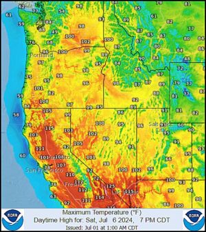
Kansas City, July 1 (World Weather Inc.) – Temperatures will gradually surge above or well above normal for this time of year for western North America, particularly California, in the coming days as a high-pressure ridge moves inland from the Pacific Ocean. This ridge will funnel warmer air across the region with temperatures surging well above 100 degrees (possibly to 115) Fahrenheit in California’s central valleys. Significant crop and livestock stress will be the greatest concern. Crop areas in the Pacific Northwest will also see temperatures surge above normal later this week and weekend with some locations potentially warming near 100 degrees as well. The environment will gradually deteriorate for crops, most notably in Washington where drought or abnormally dry conditions are prevalent in portions of crop country.
Warm U.S. July Weather To Allow Dryness To Expand
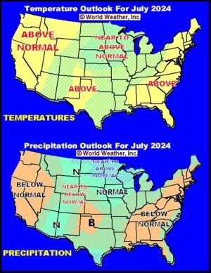
Kansas City, June 30 (World Weather Inc.) – Recent rain in the U.S. Midwest has crop conditions rated favorably in many areas, although it is too wet in the upper Midwest. Pockets of drought have managed to pop up across portions of the northwestern U.S. and in a part of the lower eastern Midwest and interior southeastern states recently while it is persisting in the central and southwestern Plains. Weather in July is expected to be warm enough to stimulate quick drying in many areas and that, according to the U.S. National Weather Service and NOAA, may lead to expanding drought. World Weather, Inc. anticipates additional wet weather in the north-central U.S. and near to below normal precipitation in many other areas.
U.S. Southeast Drying Reminiscent of 1983
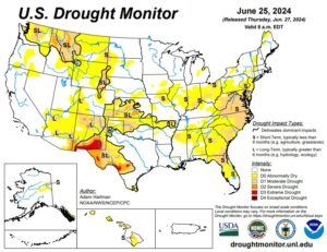
Kansas City, June 27 (World Weather Inc.) – Drier- and warmer-than-normal weather severely depleted soil moisture across the U.S. southeast and portions of the Delta this month. The pattern was reminiscent to that of 1983 when a wet spring was followed by a notably dry summer. Abnormally dry conditions or moderate drought recently evolved in the southeastern states as a high-pressure ridge diverted moisture away from the region. Although the ridge will be broad-based over the U.S. during the coming week, much of the southeastern states will see periods of rain that will attempt to chip away at the dryness. Resulting rainfall will be too light to completely fix the moisture deficits and additional rain will be needed in July to prevent a more serious bout of dryness from evolving that would hurt summer crop production. In the meantime, short-term soil conditions will improve for coarse grain, oilseed, cotton and other crops due to timely rainfall. Portions of the Delta and southeastern states may not get enough rain to seriously change drought status leaving the potential for further crop and soil deterioration during future periods of warm and dry weather.
U.S. Central, South Plains Weather Has Mixed Ag Impact
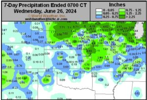
Kansas City, June 28 (World Weather Inc.) – A mix of very warm to hot temperatures and periodic rain in recent weeks has had a mixed impact on agriculture in the central and southern Plains. There has been some expansion of drought in Oklahoma while some reduction occurred in Kansas. The environment has been stressful for livestock at times while wheat maturation and harvest progress has advanced around periods of rain. These weather traits of late are expected to prevail through the first ten days of July with similar impacts. The heat and limited rainfall in Oklahoma and Texas may prove stressful for livestock and unirrigated summer crops while alternating periods of rain and sunshine along with some occasional heat will support wheat maturation and harvesting from Kansas northward to Nebraska. Some of the rain in Nebraska, Kansas and Colorado may prove to be temporarily disruptive to harvest progress, but very little threat to grain quality is likely
Weekly Citrus Weather for Tuesday, July 25, 2024
Kansas City, June 25 (World Weather Inc.) – The moisture profile improved significantly across Florida after a few weeks of significant rainfall. Rain and irrigation continued to support a good environment for citrus despite drier weather in May and earlier this month. Frequent rainfall will evolve during the coming week and help maintain a good outlook fruit development. In Mexico, Tropical Storm Alberta brought torrential rain to portions of northeastern and east-central Mexico last week. Severe flooding was noted in portions of Tamaulipas, Nuevo Leon, and Veracruz. Impacts om citrus trees and fruit development should be far more favorable than detrimental. None of the wind associated with the storm should have been great enough for a serious impact on crops. Brazil’s citrus areas were seasonally dry during the past week and will not receive much rain in the coming week.