
Weekly Citrus Weather For Tuesday June 24, 2025
Kansas City, June 24 (World Weather Inc.) – Florida’s citrus region saw a good mix of rain and sunshine during the past week. With waves of rain and thunderstorms continuing on a daily basis during the coming week, citrus development conditions will remain generally good. Mexico’s citrus areas reported abundant rain at times with flooding possible in portions of Veracruz. Long-term citrus conditions are favorable, though the wettest locations would benefit from a period of drier weather. The main citrus areas in Mexico will remain in a wet weather bias during the coming week and flood potentials will increase. Brazil’s citrus areas will have a few opportunities for rain during the coming week. However, resulting precipitation will be too light to significantly slow farming activity.
NW U.S. Corn Belt Rain Next Week Extremely Important
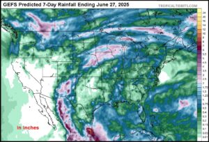
Kansas City, June 20 (World Weather Inc.) – Soil moisture is running low across a small, but important, part of the northwestern Corn and Soybean Belt. This weekend’s heat wave will exacerbate the situation raising the importance of significant rain falling in the region next week. Most computer forecast models have suggested rain will fall from eastern Nebraska and southeastern South Dakota into Iowa, southern Minnesota and neighboring states. By the time next week’s rain is due to begin soil conditions in a part of the described region will be running very short in the topsoil and short to very short in the subsoil. Crop and livestock stress will be on the rise as well. Confidence is high that the timely rain event will occur as advertised, but if it fails the region could be thrust into a more threatening environment for this year’s production.
Mid-South U.S. Drying To Be Closely Monitored
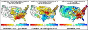
Kansas City, June 20 (World Weather Inc.) – Wet weather in the Mid-South region of the United States has been quite impressive this year with some parts of the Delta, Tennessee River Basin, Kentucky and Oklahoma each reporting record or near record rainfall at various times during the spring. Weather pattern changes forthcoming over this next week will bring the region some beneficial drying. The beneficial drying can probably occur over a week to ten days without disturbing too many folks, but there is potential that drying will become longer lasting and the region needs to be closely monitored for late summer dryness issues.
Weekly Citrus Weather for June 17, 2025
Kansas City, June 18 (World Weather Inc.) – Mexico’s monsoon season is beginning to kick in and this year promises to be quite wet for the nation. Prolonged drought should be eased in many areas and that should translate into better citrus development especially in 2026. Some of the rain has come a little late for this year’s crop, although improvements are likely. In the meantime, Florida citrus areas were wettest in west-central areas while the east was a little drier than usual during the past week. The outlook for citrus development remains favorable in Florida because of previous rain earlier this season. In the meantime, citrus areas in northern Sao Paulo and southwestern Minas Gerais, Brazil received very little rain during the past week while southwestern areas received sufficient amounts to maintain favorable off season tree development.
High Pressure To Bring Heatwave To East U.S., Rain To Canada
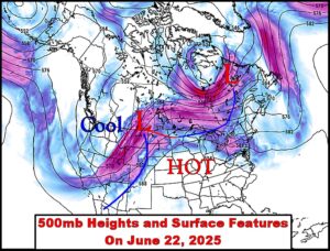
Kansas City, June 17 (World Weather Inc.) – An active jet stream and seasonal weather changes are combining this week to bring on a strong ridge of high pressure in the central United States and a trough of low pressure over British Columbia, Canada and the U.S. Pacific Northwest. These two features in a normal year could lead to stagnating weather across North America, but the jet stream is much too strong to allow a persistent ridge of high pressure over the central United States – at least not now. The ridge and trough will work together as they move from west to east across North America resulting in a heat wave for the central and eastern U.S. and the best chance for significant rain in Canada’s dry region seen this year.
Southern U.S. Hard Red Wheat Too Wet; More Rain Coming
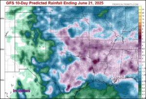
Kansas City, June 10 (World Weather Inc.) – Another week has passed in the southern U.S. Plains with rainfall well above normal. The precipitation frequency has been much too high in recent weeks and soil conditions are saturated in many areas. The wet bias will continue through the middle part of next week and that will likely lead to more potential for winter wheat quality declines and possible production cuts. The wettest conditions have mostly been from southern Kansas through northern Texas where crops are filling and maturing. Some of the crop has been harvested, but rain is now delaying that process and also raising the risk of head sprouting. A little farther to the north some of the crop has experienced a little wet weather disease. In the meantime, areas in northern Kansas, parts of Nebraska and Colorado have had much less rain and would actually benefit from a boost in precipitation.
Weekly Citrus Weather For Tuesday, June 11, 2025
Kansas City, June 10 (World Weather Inc.) – Waves of rain were noted in Florida’s citrus region during the past week. With more rain on the way in the coming week, citrus development conditions will remain relatively favorable. Several counties remain in a drought or enduring abnormally dry conditions and the need for more significant rain will remain high, although sufficient rain fell earlier this month to bring relief and to support tree and fruit development. Mexico’s citrus areas received varying amounts of rain during the past week with the most significant precipitation noted in portions of west-central and east-central Mexico. Monsoonal rain will occur on a frequent basis during the coming week. East-central and western Mexico will receive several inches of rain and will maintain a good environment for fruit and tree development. Brazil citrus areas will either be dry or receive limited rainfall during the coming week. Harvesting will advance with few disruptions.
World Cotton Weather For June 10, 2025
Kansas City, June 10 (World Weather, Inc.) – Cotton production areas around the world continue to experience favorable weather for this production year. Cotton is well advanced in South America with the harvest making good progress in Argentina and just beginning in parts of Brazil; though, production is expected to be high this year, despite late planting in Mato Grosso. Weather in West Africa is nearly ideal for planting and early season development and conditions in India have been good and are expected to remain that way for a while. China’s Xinjiang weather has been just fine so far this year, although some rain would be welcome to supplement irrigation. Temperatures have been seasonable in Xinjiang China and not nearly as cool in the spring this year as they were in 2024.
U.S. Midwest Drier Crop Areas To Be Tried By Pressure Ridge
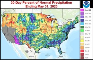
Kansas City, June 5 (World Weather Inc.) – Soil moisture has been favorably rated this spring in key Midwestern crop areas, despite some notably lighter than usual precipitation in the central and west. Drier and warmer weather is due in the middle of June and if significant rain does not fall before the heat comes along some areas may quickly turn too dry. The forecast offers some light precipitation before the heat arrives, but more rain will be needed.
Weekly Citrus Weather For June 3, 2025
Kansas City, June 3 (World Weather Inc.) – Florida’s citrus region received much-needed rain during the past week. Additional rain during the coming week will further bolster soil moisture and maintain a good environment for aggressive citrus growth. Mexico’s citrus areas also received timely rain during the past week. The rain helped improve or maintained a good environment for development. Western and east-central Mexico will receive additional rain during the coming week while northeastern Mexico again dries down. Brazil’s citrus areas will trend wetter than usual during the coming week. The waves of rain may slow harvesting and general farming activity.
World Soil Moisture Areas of Concern For Friday, May 30, 2025
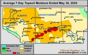
Kansas City, May 30 (World Weather Inc.) – Some traders have been complaining that world weather is not adverse enough to drive the commodity futures markets higher. Of course the problem is more a demand issue than a production issue, but it certainly would not hurt for the weather to turn more adverse and threatening to production in a few areas to help drive the market interest. So far this year’s weather has been mostly good, but there are a few areas of interest out that that should be reviewed before the weekend begins. The following is a short compilation of world soil moisture snapshots with a brief comment regarding what should happen next.
Severe Weather Threat Rises for Central, East U.S. Next Week
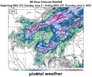
Kansas City, May 30 (World Weather Inc.) – Drier- and much-warmer weather slated for the central and eastern United States this weekend into early next week will be a welcome change after frequent precipitation and cooler-than-usual weather of late. However, the warmup will pull moisture out of the soil and place it in the atmosphere which is likely to destabilize because of the warmer environment. Warm and moist air rising across the Great Plains and Midwest will be displaced by cooler and drier air coming out of Canada during mid-week next week. As these two distinctly different air masses collide the odds are great that strong to severe thunderstorms will evolve in many areas from the Great Plains through the Midwest and mid-south regions. Hail, damaging wind, possible tornadoes and heavy to torrential rainfall will result possibly inducing some damage to crops and property.
Tropical Storm Alvin Develops Southeast of Mexico
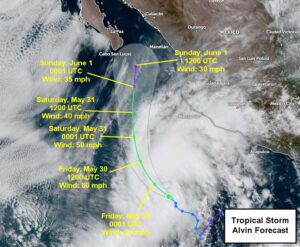
Kansas City, May 29 (World Weather Inc.) – Tropical Storm Alvin, the first named storm of the 2025 eastern Pacific Ocean Hurricane Season, developed earlier today roughly 375 miles southwest of Manzanillo, Mexico, with maximum sustained wind speeds near 40 mph. Alvin is expected to intensify and curve northward going into Friday, then will gradually weaken over the weekend. Alvin’s remnants will bring enhanced shower and thunderstorm activity to southern Baja California and into northwestern Mexico. Going into next week, Alvin’s remnants may contribute to enhanced rainfall in the Southwest U.S. and southern Great Plains. A closer watch on this system will be needed in the coming days for any and all updates to Alvin’s forecast.
U.S., Canada Summer 2025 Weather Not Bad For Agriculture
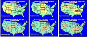
Kansas City, May 28 (World Weather Inc.) – It seems like the last snowstorm just occurred a week or two ago, but spring is almost over and now everyone’s attention is shifting to summer weather. Much of the fear over a hot, dry, summer has at least been temporarily put to rest by recent weeks of precipitation in the United States, but worry has increased over returning drought in Canada’s central Prairies and there is quite a bit of dryness in the western United States. Atmospheric trends for the summer are still suggesting timely rain in Canada’s Prairies to prevent a serious drought from dropping production dramatically, but conditions might not be ideal. Weather in the U.S. should be favorable, although the wet bias lingering from spring into June will raise some concerns. The Delta and Tennessee River Basin as well as the northeastern U.S. will likely dry down this summer and some dryness may return to the central Plains, but serious problems from weather may be limited to a few areas which is not unusual for a summer season.
Weekly Citrus Weather for May 27, 2025
Kansas City, May 27 (World Weather Inc.) – Florida’s citrus region saw several waves of rain during the past week that helped improve the moisture profile. Additional rain during the coming week will further bolster soil moisture and continue to chip away at the dryness that evolved earlier this spring. Citrus conditions will remain favorable. Mexico’s citrus areas also received early rain during the past week with more on the way in the coming days. Citrus development conditions will improve or remain favorable. Brazil’s citrus areas will have a few opportunities for light and erratic rain during the coming week. No major harvest delays are expected.
U.S. Mid-South Wet Spring To Last Another Week
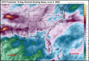
Kansas City, May 23 (World Weather Inc.) – Anomalously wet spring conditions this year from the lower Ohio River Valley into the northern Delta, Tennessee River Basin and southeastern Plains has been a frustration for many farmers. Planting delays have been ongoing since the initial flooding rain event occurred in late March and early April. Rain continued to evolve each time fields became firm enough for a little fieldwork to begin and the same phenomenon is occurring this week. Recent drying was welcome, but now there will be a full week of frequent rain that will reverse all of the drying that has occurred recently and raise the potential for new flooding. This week’s rain may be “the last straw” for producers in parts of the region that may have to abandon their fields or at least fall back to a possible late-season, short variety, soybean crop if they believe drying will eventually come to the region.
U.S. Pacific Northwest Warming To Enhance Dryland Crop Stress
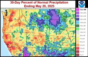
Kansas City, May 21 (World Weather Inc.) – Limited precipitation in recent weeks promoted a gradual drying trend for the U.S. Pacific Northwest. Unirrigated fields are short to very short of moisture resulting in stress for winter wheat and barley that are approaching and entering reproduction. Recent temperatures have been mild to cool, but a warming trend will soon add to plant moisture stress by raising its moisture demand. Crop stress is likely to increase greatly as the temperatures trend warmer due to the lack of moisture in the soil and the rapid advancement of winter crops into reproduction. Irrigated winter, spring and summer crops will remain in favorable condition.
Weekly Citrus Weather For Tuesday, May 20, 2025
Kansas City, May 20 (World Weather Inc.) – After receiving significant rain earlier this month, Florida again received little to no rain during the most recent week. The region still had enough moisture to support new growth. The region will see a mix of rain and sunshine during the coming week that will marginally bolster soil moisture and maintain relatively good citrus conditions. Brazil’s citrus areas were dry during the past week and will remain dry during the coming week. Harvesting will advance swiftly. A surge of pre-monsoonal rain will expand across the main citrus areas in Mexico during the coming week. The rain will improve citrus conditions in east-central and northeastern Mexico.
Recent U.S. Rain Greatly Improves Topsoil Moisture
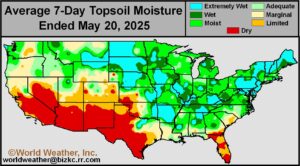
Kansas City, May 20 (World Weather Inc.) – Rain has fallen beneficially across nearly all of the most important spring and summer crop areas in the northern U.S. Plains, Midwest, Delta and interior southeastern states over the past week. Topsoil moisture that was rated poorly a week ago in the northern Plains and western Corn and Soybean Belt has been bolstered by the precipitation. Subsoil moisture is still low in the northern and central Plains and in portions of the northwestern and west-central Corn and Soybean Belt, though the situation has improved enough for a short term bout of more aggressive early season crop development and planting as drier days resume. Cool temperatures will conserve the soil moisture for several days before warming returns.
Severe Weather from Southern Plains to Tennessee River Basin
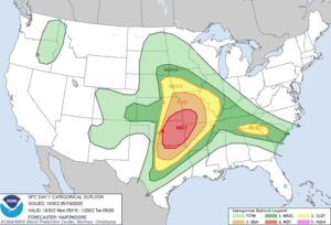
Kansas City, May 19 (World Weather Inc.) – Satellite imagery and radar are beginning to show the initial signs of a notable convective outbreak this afternoon and evening. The thunderstorm clusters will be disorganized for a while this afternoon before a more solid line of storms evolves this evening. Strong to severe thunderstorms are quite likely producing hail, damaging wind and tornadoes from the eastern Great Plains into the central Midwest. The storms will shift farther to the east Tuesday. A similar situation occurred during the weekend producing serious damage to property in the lower Midwest Friday and in the central Plains Sunday.
Frost, Freezes In North-Central U.S., Canada Have Low Impact
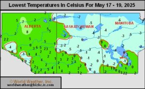
Kansas City, May 18 (World Weather Inc.) – Frost and light freezes in the north-central United States and in Canada’s eastern Prairies had a very low impact on crops during the weekend. Some vegetative damage resulted, but permanent production impacts should have been rare if they occurred at all.
U.S. Midwest Soil To Trend Wetter; Possibly Too Wet South
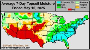
Kansas City, May 16 (World Weather Inc.) – An impressive rain event brought drought and dryness relief to the western Dakotas, southeastern Saskatchewan and southwestern Manitoba the past two days. An active weather pattern in the United States during the next seven days will bring on wetter field conditions to many areas from South Dakota to the northern Delta and lower Midwest. The moisture boost will be welcome in Iowa, Nebraska, northern Missouri and areas east into central Illinois and northern Indiana; however, the return of rain to the lower Midwest and northern Delta will not be welcome since planting in those areas has been a constant struggle since flooding occurred in late March and early April. Improved crop development potential and better future planting conditions are likely in areas relieved from dryness, but longer field-working delays are likely in the lower Midwest where some areas are still too wet from previous rain.
Northern Plains Rain Winding Down After Big Moisture Boost
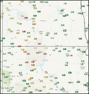
Kansas City, May 16 (World Weather Inc.) – A general soaking rain has fallen from southwestern Manitoba and southeastern Saskatchewan through the western Dakotas in the past couple of days. The rain event is expected to wind down with most of the precipitation ending overnight tonight and early Saturday morning. Additional moisture totals will be light, though, 1.00 to more than 4.00 inches has resulted changing the moisture profile greatly for much improved planting and emergence conditions for spring and summer crops.
Eastern Canadian Prairies, Neighbors Face Frost, Light Freezes
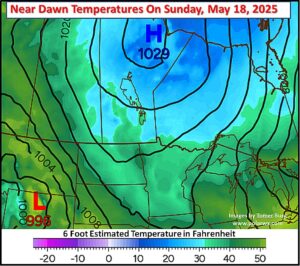
Kansas City, May 15 (World Weather Inc.) – A late blast of cold air will advance across the eastern Canadian Prairies and neighboring locations in North Dakota and northern Minnesota this weekend following a significant rain event. Frost and light freezes are expected in portions of Manitoba, eastern Saskatchewan, and pockets of North Dakota and northern Minnesota from this event. The coldest conditions will be restricted to the eastern Canadian Prairies, where only a few crops have emerged. Other than some potential burning back of the crop or leaf damage, overall production impacts should be minimal. Crops that do experience some damage may be replanted.
U.S. Northern Plains, SE Canada Prairies To Get Needed Rain
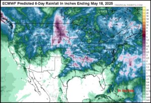
Kansas City, May 14 (World Weather Inc.) – A significant shift in weather is expected portions of the northern U.S. Plains and a part of eastern Canada’s Prairies starting tonight and lasting into Saturday followed by another rain event next week. These two precipitation events will greatly ease drought and abnormally dry conditions that have been prevailing in the western Dakotas for months and ease dryness that has just recently evolved in the eastern Dakotas and Minnesota after a very warm and dry period earlier this week and last weekend. The region produces a significant amount of spring wheat, barley, oats, sunseed, coarse grain, oilseeds, sugarbeets and a few other crops. Continued dryness would have had a large negative impact on production especially in the western Dakotas, but relief will come. The Missouri River Basin will be wettest and flash flooding is possible.
Weekly Citrus Weather For Tuesday, May 13, 2025
Kansas City, May 13 (World Weather Inc.) – Abundant rainfall was noted in Florida’s citrus region during the past week. The rain helped improve the drought and maintained a good environment for citrus growth. Drier weather will return during the coming week as high pressure gradually builds over the region. Citrus development conditions will remain favorable. Brazil’s citrus region received rain during the past week that was beneficial for any citrus that is still growing. Drier and warm weather will be beneficial for maturation and early-season harvesting during the coming week. Mexico’s citrus areas will dry down during the coming week despite some spotty rain.
U.S. Heat Wave To Be Followed By “Some” Beneficial Rain
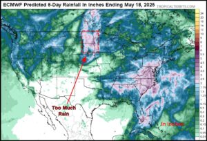
Kansas City, May 12 (World Weather Inc.) – Unusually hot temperatures occurred Sunday in the upper U.S. Midwest and northern Plains as well as some areas in southeastern Canada’s Prairies. Soil moisture has been steadily declining across the region in recent days stressing some newly emerged and established crops as well as livestock. The heat is expected to prevail two more days and then abate. Two storm systems are advertised to pass through the region in the next ten days bringing more relief than just cooler temperatures. Rain is expected and although each system may not produce a perfect distribution of moisture, between the two events soil moisture should be improved.
Portions of U.S. Southeast Get Welcome Rain
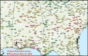
Kansas City, May 12 (World Weather Inc.) – Portions of the southeastern United States received significant rain during the weekend as a slow moving upper level low pressure center started to move through the region. The system will continue to produce rain in some areas for the next three days bringing some additional relief to previously dry areas. This week’s rain will be greatest in areas from eastern and northern Georgia and to Virginia with lighter rain west into the northern Delta and Tennessee River Basin. In the meantime, some of the rain in southern Georgia and southeastern most Alabama may have been disappointing, although welcome.
U.S. Pacific Northwest Dryland Crops Need Rain

Kansas City, May 9 (World Weather Inc.) – Recent warm and dry weather in Washington and northern Oregon has reduced soil moisture and raised some unirrigated winter crop stress. The need for significant moisture in dryland production areas is steadily rising because of decreasing soil moisture while crops are in the joint to boot stage. A few crops in the driest area have begun to head and that makes the urgency for rain much greater since dryness would likely cut into yields. Dry conditions are expected to continue in central Washington and in the Columbia River Basin over the coming week to ten days and there may be a couple of very warm days this weekend. Cooling is likely next week, but the potential for significant rain remains very low suggesting crop stress will continue to rise.
Nebraska, Northern Kansas to Michigan Driest Next 10 Days
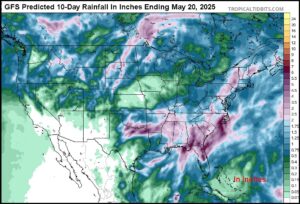
Kansas City, May 9 (World Weather Inc.) – U.S. soil moisture is rated adequate to surplus in southern, central and eastern portions of the Midwest as well as the Delta, Tennessee River Basin and portions of the southern Plains. Drying has been and will continue to occur in the northwestern one-third of the Midwest including the Dakotas, Minnesota, Wisconsin, Iowa and Kansas and will evolve in northern Illinois, northern Missouri and areas northeast to parts of Michigan and Wisconsin through early next week. Drying in the northwestern Corn and Soybean Belt has generated greater interest because of the already firming condition of soil and the anticipation of excessive heat this weekend and early next week. Some relief may occur in a part of the upper Midwest next week, but areas from Nebraska and northern Kansas to Michigan may be in a net drying pattern for nearly ten days.
Southeast U.S. To Get Drought Relief
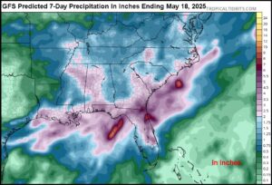
Kansas City, May 7 (World Weather Inc.) – The far southeastern corner of the United States has been enduring erratic rainfall this spring that has allowed warm temperatures to evaporate moisture from the soil faster than it has received it. As a result, abnormally dry conditions and various stages of drought have been evolving in recent weeks from Florida and southeastern Alabama through a large part of southern and eastern Georgia to portions of eastern South Carolina and southeastern North Carolina. A large, cut-off, upper level low pressure system over the lower Mississippi River Basin during the next few days should eventually provide a moisture surge through some of these drier areas bringing much needed relief and improving development potential for cotton, corn, soybean, peanut and a host of other crops.
Weekly Citrus Weather for Tuesday, May 6, 2025
Kansas City, May 6 (World Weather Inc.) – Florida’s citrus areas finally saw some spotty rainfall during the past week. Precipitation was too light to fix the drought and additional rain is still needed to support ideal citrus conditions. An unusually wet weather bias is slated for Florida during the coming week. Rain will continue to improve soil moisture and may be enough to break the drought, at least in parts of citrus country. Brazil’s citrus areas received limited rainfall during the past week and will remain drier than usual in the coming week. The main citrus areas will still have enough moisture to support new growth. In Mexico, the east-central and northeastern production areas will again see a good mix of rain and sunshine during the coming week. Citrus development conditions will improve or remain favorable.
World Wheat Weather For May 6, 2025
Kansas City, May 6 (World Weather Inc.) – Drought has evolved in a part of east-central China and the below normal rainfall that has prevailed in recent weeks and months has brought much speculation to the overall condition of wheat and its production potential. A large part of the China crop is irrigated, but that which is not will lose some production potential. Very warm to hot weather is expected next week as the crop finishes reproduction and fills which may be stressful for many crops – both irrigated and not irrigated. In the meantime, wheat conditions have improved and will improve additionally near the Black Sea. Conditions in the U.S. have not been ideal with some flood damage in Oklahoma and in the lower Midwest and Delta. In the meantime, a close watch on Australia is under way because of a limited rainfall outlook for the next ten days. Argentina is expected to have a good year and there are parts of Europe that could run into some dryness, although that is not a sure thing.
2025 East Atlantic Tropical Cyclones May Reach Gulf Of Mexico
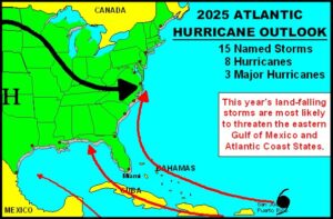
Kansas City, May 5 (World Weather Inc.) – Cooler ocean surface temperatures in the Atlantic Ocean this year relative to those of the past two years may help reduce the number of tropical cyclones that develop, but the impact may be greatest on the steering of those storms that form off the Africa coast. Unlike the past two years when storms from the eastern Atlantic Ocean were often steered away from the Gulf of Mexico, this year’s storm paths may favor a greater number of systems reaching the Gulf of Mexico and/or the southeastern United States.
U.S. May Weather Warmer Biased, Drier In Parts of Midwest
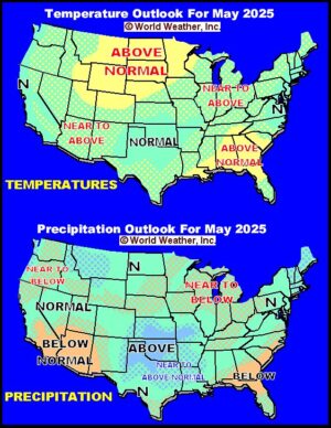
Kansas City, April 30 (World Weather Inc.) – The most anomalously great precipitation in U.S. crop areas during May will be that which occurs in the southern Great Plains over the coming week to ten days. There will also be a boost in rainfall across the northern Plains and in Canada’s Prairies during the middle to latter part of the month while the Midwest experiences a lighter than usual precipitation bias after this first week. Temperatures will be warmer than usual in many areas during May excepting the rainy areas of the southern Plains and some coastal areas in the west and eastern states where readings will be close to normal on average for the month.
Weekly Citrus Weather For Tuesday, April 29, 2025
Kansas City, April 29 (World Weather Inc.) – Drought continues to intensify in Florida’s citrus country due to another week of limited or no rain. Irrigation continued to support relatively good development conditions. However, the need for significant rain is high. The citrus region will have a few opportunities for rain during the coming week that will ease a minor amount of the dryness. Seasonal rains are still a few weeks away and additional rain will be needed to completely fix the moisture deficits. Brazil’s citrus areas saw several waves of rain during the past week that maintained a good environment for late-season growth. Drier weather will evolve during the coming week and net drying is slated for most locations. East-central and northeastern Mexico will see a good mix of rain and sunshine during the coming week that will be beneficial for the citrus.
Severe Weather Expected for Minnesota, Iowa, and Wisconsin
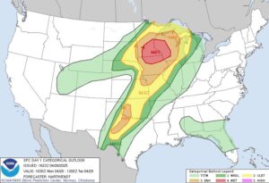
Kansas City, April 28 (World Weather Inc.) – Convection was increasing in interior western Minnesota at mid-day today getting ready for several hours of stormy weather this late afternoon and night. The storms will produce generalized heavy rain, hail and some tornadoes in the upper Mississippi River Basin with a broken line of severe thunderstorms extending from southwestern Iowa through northeastern Kansas and northwestern Missouri to north-central Texas. The most active part of the severe weather outbreak will impact central and eastern Minnesota, western Wisconsin and northern Iowa.
Parts of Texas Panhandle, Rolling Plains Get Significant Rain
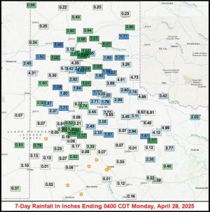
Kansas City, April 28 (World Weather Inc.) – Another round of rain fell across the Texas Panhandle, the Rolling Plains and northern portions of West Texas during the Friday through Sunday period. Some of the rain was heavier than expected bringing seven-day rain totals in the 4.00 to 6.81-inch range in several areas and 1.00 to 3.00 inches in others. The moisture has greatly improved spring planting prospects for corn, sorghum and cotton in the wetter areas, although many other locations in West Texas and the northern Texas Panhandle still have need for greater moisture.
Southern U.S. Plains Planting Outlook Improves
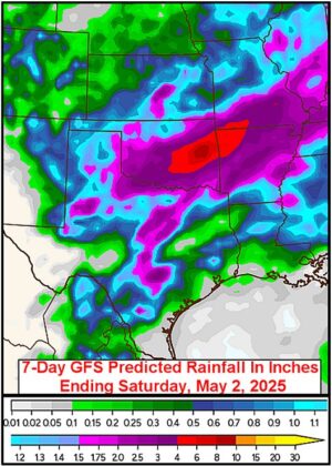
Kansas City, April 25 (World Weather Inc.) – Changes in weather taking place in North America ending the prolonged drought pattern brought on by the 22-year solar cycle will lead to better precipitation in the southern U.S. Plains this spring. That will translate into improved soil moisture and water supply and should also lead to a better outlook for dryland production of corn, sorghum and cotton especially in the southwestern Plains. These changes come a little late for dryland winter wheat and canola, but crop improvements are likely there as well. The Southern Plains now have a relatively good potential to be wetter biased in the next few weeks
Weekly Citrus Weather For Tuesday, April 22, 2025
Kansas City, April 22 (World Weather Inc.) – Florida’s citrus areas were dry during the past week with little rain on the way in the coming week. Irrigation will continue to be used statewide, though the need for rain is increasing. Brazil’s citrus areas will receive a little more rain in the coming week compared to recent weeks. The precipitation will be welcome and should support new growth. Production potentials remain lower than usual due to adverse conditions this season. Mexico’s citrus areas are also drying down a little too much and would welcome more rain. The spotty precipitation that occurs through early next week will be unable to significantly impact long-term soil conditions.
U.S. Crop Areas To Be Wetter Biased Into May
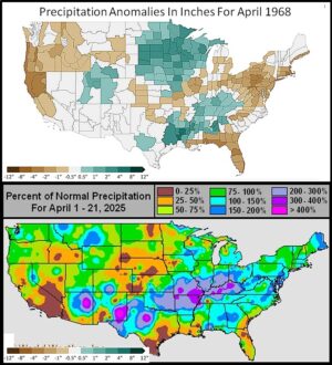
Kansas City, April 21 (World Weather Inc.) – Recent weather trends bringing rain to the U.S. Great Plains and Midwest and continuing the wet bias in the Delta and Tennessee River Basin has not seriously changed the outlook for spring 2025. To a large degree, the year is still looking much like that of March through May of 1968. Improved soil conditions have occurred in parts of the lower Midwest, Delta and Tennessee River Basin since the big flooding rain event of earlier this month, although areas of standing water in low-lying areas remain in northern parts of the Delta, Kentucky and a few areas north of the Ohio River. River flooding is also still occurring on the lower Ohio and lower Mississippi Rivers while more recent rain saturated the soil from Oklahoma and parts of north-central Texas into Illinois, Indiana, eastern Iowa and Wisconsin. More rain is likely in the next two weeks from the Great Plains through the Midwest and Delta to the interior southeastern states keeping spring fieldwork slow in some areas.
U.S. Hard Red Winter Wheat Rain To Offer Partial Relief
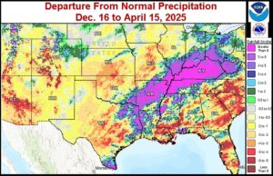
Kansas City, April 16 (World Weather Inc.) – Soil conditions in most of the U.S. hard-red winter wheat crop region have remained drier biased since late 2024. Soil moisture remains short to very short and drought intensity varies across the crop region with abnormally dry to severe drought conditions present as of April 8. Meaningful rainfall over 1.00 inch has not broadly occurred over this region since November 18th, 2024 with a few bouts of light precipitation occurring in isolated instances since then. To mitigate this dryness, much more precipitation will be needed in the coming weeks. Rain advertised over the next couple of weeks will provide some partial relief, but it remains debatable how significant the precipitation will be.
Weekly Citrus Weather For Tuesday, April 15, 2025
Kansas City, April 15 (World Weather Inc.) – Florida’s citrus region received limited rain during the past week. Drier-than-normal weather will prevail during the coming week and the need for irrigation will continue statewide. Brazil’s citrus areas saw a mix of spotty rain and sunshine during the past week. More significant rain is slated for the region during the coming week, which will improve the moisture profile and support better development conditions. Mexico’s citrus areas will remain mostly dry during the coming week as well. A good shot of rain would be welcome later this month and early May.
Southeastern U.S. Planting To Advance Better With Dry Week
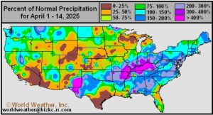
Kansas City, April 14 (World Weather Inc.) – A week of dry weather is slated for the southeastern United States this week. The drier weather will come after recent rain and should help promote aggressive corn, cotton and some early season soybean planting. Areas from Florida and southeastern Alabama to Virginia have not been as wet as areas to the northwest in the Tennessee and Ohio River Basins where torrential rain and flooding are threatening to cut into area planted this year. After this week’s drier weather in the southeastern states some rain will develop again to maintain a mostly good balance of weather and field conditions for planting and crop growth.
Returning Rain in Delta, Ohio Basin To Prolong Planting Delay
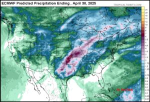
Kansas City, April 14 (World Weather Inc.) – River and stream flooding remains widespread in the lower Ohio River Basin and down through the lower Mississippi River Basin as the aftermath of an estimated 24.47 trillion gallons of water was poured over the lower Midwest into the Delta and parts of the Tennessee River Basin earlier this month. The impact on agriculture and personal property has been quite severe. Dry weather will continue in the region this week, but returning rain is expected next week and even if the precipitation is only light it will prevent fieldwork from resuming and induce new delays. The returning rain may occur periodically through the end of April prolonging spring planting delays and raising the potential for both some farmers to switch from intending on planting corn to planting soybeans and for some field abandonment.
U.S. Midwest, Plains Late Spring Weather To Look Like 1968
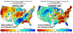
Kansas City, April 10 (World Weather Inc.) – Weather on planet earth is the result of the mixing of many atmospheric and oceanic parameters and most of those parameters are cyclical in nature. However, each of the influences on weather operate independently resulting in the overlapping of cycles that rarely line up similarly from one year to another. Meteorologists have a tough time making long range predictions because of this situation and will usually use the most dominating weather influences to derive their forecasts. This spring there are three larger influences on weather and they include the solar cycle, the lunar cycle and ENSO (El Nino/Southern Oscillation). World Weather, Inc. has looked at 1968 as a possible analog year for spring 2025 because of its similarity from each of these three patterns. If correct, the remainder of spring should trend wetter in the northern U.S. Plains, southern Canada’s Prairies and the upper U.S. Midwest while the Pacific Northwest receives normal precipitation and more rain falls across the region from eastern Texas to the Delta and lower Ohio River Basin. There may also be ongoing dryness from the southwestern Plains into the west-central Corn and Soybean Belt and in the southeastern states.
Weekly Citrus Weather For Tuesday, April 8, 2025
Kansas City, April 8 (World Weather Inc.) – Drought or abnormally dry conditions persist in Florida’s citrus country. The region will only have a few opportunities for light rain during the coming week that will be unable to significantly improve the moisture profile. Irrigation will continue to be used on a daily basis. Brazil’s citrus areas saw a mix of spotty rain and sunshine during the past week. Periods of erratic rainfall will continue in the coming days and will maintain relatively good citrus conditions. Mexico’s citrus areas received little to no rain during the past week. Mostly dry weather will persist through early next week and the need for more significant rain will increase.
U.S. Hard Red Winter Wheat Sees Hard Freezes
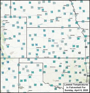
Kansas City, April 6 (World Weather Inc.) – Hard freezes occurred this morning in U.S. hard red winter wheat production areas. The cold burned new vegetative growth after recent bouts of unusually warm temperatures. The impact of the cold was likely limited since winter crops were not far enough advanced to be permanently damaged. Wheat has suffered from wild temperature swings since the middle of winter, blowing dust and drought. The lack of generalized precipitation this spring may be making it difficult for crops to recover from previous damage. A mild to cool temperature regime and periods of rain are necessary for crops to recover from damage this year and the forecast is not promoting such conditions.
Lower U.S. Midwest, Upper Delta Flooding Worsening
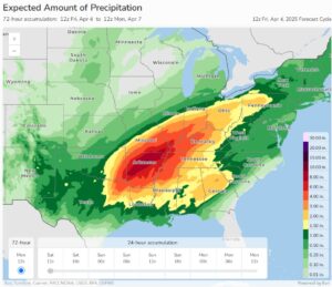
Kansas City, April 4 (World Weather Inc.) – Excessive rain has already fallen across the lower U.S. Midwest and northern Delta in the past two days and the precipitation event will continue into Sunday resulting in serious property and some crop damage. The worst impacted areas will be from the heart of Arkansas through southeastern Missouri and western Tennessee to Kentucky where there has already been 2.50 to 8.34 inches of rain between dawn Wednesday and noon today (Friday). Another 2.00 to 6.00 inches of rain is expected with a few amounts to 8.00 inches by Sunday bring some of the rain totals to the range of 5.00 to 12.00 inches and a few amounts near or above 14.00 inches. Any crops that were planted early will likely have to be replanted and delays in future fieldwork are expected to last at least two weeks and perhaps notably longer if new rain falls. Flooding will eventually reach the Ohio, lower Tennessee and lower Mississippi Rivers causing barge traffic to be disrupted and creating some additional farmland to be impacted near the rivers.
Central, SW U.S. Dryness May Prevail Into July
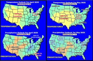
Kansas City, April 4 (World Weather Inc.) – “Portions” of the central and southwestern United States have been struggling with below normal precipitation since the latter half of summer 2024 with the exception of November. World Weather, Inc. believes a part of this dryness will likely prevail through the balance of spring and into early summer. In the meantime, a wetter bias is expected at times in the eastern Midwest and a part of the Delta and a change toward wetter conditions should evolve in the far northern Plains and upper Midwest late this spring followed by a drier bias in July. The southeastern states will experience less than usual rain during the spring and then greater rain during the summer. Temperatures should be most anomalously warm in the central states and a part of the Rocky Mountain region until July.
U.S. Hard Red Wheat To Be Stressed Again By Cold
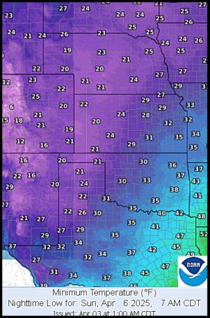
Kansas City, April 3 (World Weather Inc.) – Weather conditions have been anything, but settled this year in U.S. hard red winter wheat production areas. Wild temperature swings, extremely dry conditions, blowing dust and a few bouts of light rain and snow have been reported. The drought conditions have been most disturbing because with that has come some very dry and warm conditions recently and now there is a good chance for hard freezes to occur Sunday across most of the production region. The freezes will just be one more bout of stress that this year’s crop has had to endure, but with it will be some potential for minor damage to recent growth that may act as a deterrent against normal plant development until rain and warming returns again. The best news for the region, though, is that rain and snow will precede the cold and that will provide the potential for crop improvement once the cold passes.
Severe Weather, Flooding To Impact U.S. Crops, Property
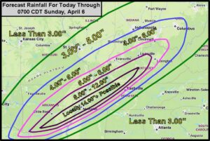
Kansas City, April 2 (World Weather Inc.) – Significantly contrasting air masses meeting up over the U.S. lower and eastern Midwest and Mid-South regions over the next few days will bring on a bout of severe thunderstorms and flooding. Areas of the Ohio and Mississippi River Valleys are being monitored for the potential for severe weather tonight into Thursday morning. Risks from these storms include; possible tornadoes, large hail, damaging wind, and heavy rain. The conflicting air masses will also set the stage for frequent bouts of heavy rain and the potential for additional strong to severe thunderstorms into Saturday. Rainfall totals going into Sunday will vary between 6.00 and 12.00 inches from Arkansas into portions of the Ohio River Valley and northern Delta with up to 14.00 inches possible from southern Kentucky into eastern Arkansas. If this forecast verifies, flooding will be a risk and may case damage to winter wheat in this region. Cooler-biased weather will then enter the Plains and eastern Midwest this weekend and early next week resulting in frost and freezes and a possible impact on the more advanced winter crops.
Lower U.S. Midwest Flooding Rain To Delay Fieldwork
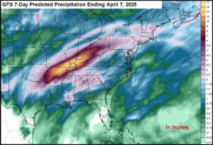
Kansas City, March 31 (World Weather Inc.) – An active weather pattern is in store for portions of the lower U.S. Midwest and northern Delta this week and weekend. A strong upper-level trough of low pressure will develop across western North America during mid- to late-week that will help send a series of disturbances across the Delta and Midwest. These disturbances combined with moisture from the Gulf of Mexico will promote waves of heavy rain that will likely promote significant flooding. Structural damage because of high water will be possible and early-season fieldwork will be delayed for an extended period in the wettest areas. Damage to the winter wheat in poor drainage areas is likely throughout the region.
Hot, Dry and Windy Conditions to Persist in South US Plains
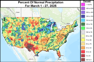
Kansas City, March 28 (World Weather Inc.) – Persistent dry and warm-biased weather has created drought conditions across the southern U.S. Plains since at least the latter half of February. A significant rain event occurred in South Texas and the Texas Coastal Ben d Thursday and overnight; otherwise, hot and dry weather prevailed from western Kansas into central and western Texas and the southwestern desert areas of the United States. Drought is either present or developing in most of the region, although the rain in South Texas has brought relief. Crop and livestock stress are occurring from western Kansas and eastern Colorado southward. In the next 7 to 10 days, minimal to no precipitation is expected to prevail across the region. Periodic warm to hot temperatures will also continue into next week, as well, particularly in Texas and Oklahoma, which will continue to amplify drought conditions and increase crop and livestock stress.
Weekly Citrus Weather for Tuesday, March 25, 2025
Kansas City, March 25 (World Weather Inc.) – Florida’s citrus areas were either dry or received limited rain during the past week. Irrigation continued to be the primary source for moisture as drought or abnormally dry conditions prevailed. The main citrus areas will see a good mix of rain and sunshine during the coming week that will ease the need for irrigation at times. Brazil’s citrus areas saw a mix of rain and sunshine during the past week. Rain will often be scattered across the region during the coming week and citrus conditions will remain favorable. East-central and northeastern Mexico will also have opportunities for rain during the next several days that will be beneficial for flowering and blooming trees.
Impressive Central U.S. Storm Brings Little Moisture Change
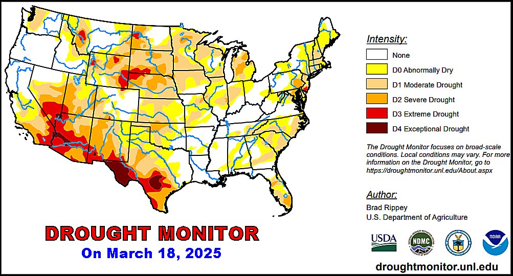
Kansas City, March 20 (World Weather Inc.) – The first official day of spring has arrived following another very impressive central U.S. storm system. This week’s storm produced an impressive wind blowing dust from New Mexico to the Midwest and inducing a blizzard from Kansas to Wisconsin; however the system failed to bring much moisture change to the heart of hard red winter wheat country and the moisture boost to the upper Midwest was a little lackluster. There is potential for additional lighter than usual precipitation in the upper Midwest later this month into early April while the central and southwestern Plains continue quite dry.
Weekly Citrus Weather For Tuesday, March 18, 2025
Kansas City, March 18 (World Weather Inc.) – Florida’s citrus areas received light rain during the past week. A large section of citrus country is abnormally dry or in a moderate drought and the need for rain is high. However, the main citrus areas will trend drier than usual during the coming week. Irrigation will be used across the state to support a good environment for citrus flowering. Brazil’s citrus areas will continue to see a good mix of rain and dry weather during the coming week. The outlook will remain relatively good. Mexico’s citrus areas were mostly dry during the past week. East-central and northeastern Mexico will have a few opportunities for spotty rain during the coming week, though not enough to support ideal flowering and early-season development.
Harsh Central U.S. Weather Reduces Wheat Recovery Potential
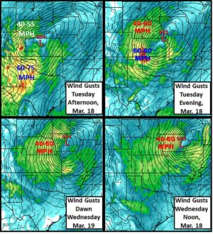
Kansas City, March 16 (World Weather Inc.) – The central U.S. windstorm lived up to every bit of its potential Friday into Saturday. Two more bouts of excessive wind are likely in the central and southern Plains in this next week and both will come with additional very low humidity, blowing dust and some additional wild temperature swings. All of this describes a classic drought pattern and concern is steadily rising that the Great Plains may be facing a serious dryness issue if changes do not occur soon. Winter wheat is losing potential to recover from the damage incurred by bitter cold temperatures in January with little to no snow on the ground. This raises the potential that production could be down significantly if late March and April do not provide wetter and milder weather.
World Cotton Weather For March 13, 2025
Kansas City, March 13 (World Weather, Inc.) – Planting season has arrived in northeastern Mexico and South Texas. Dryland fields have no moisture to germinate seeds or support early development. Some drying has also been occurring recently in western Bahia impacting that part of Brazil’s cotton crop after some late planting occurred in Mato Grosso. Mato Grosso weather has been improving more recently, but the key to its success will be rainfall and/or soil moisture after the monsoon ends in April. Eastern Australia weather has not been ideal in unirrigated fields, but the crop should still be of fair size because good early season rainfall and increased planting.
Severe Weather To Impact Midwest, Mid-South This Week
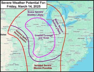
Kansas City, March 12 (World Weather Inc.) – A very strong area of low pressure is expected to move out into the central United States Friday. As it does so, greater moisture will get pulled north from the Gulf of Mexico into the Midwest, Delta, and southeastern states along with well above average temperatures. This will lead to enough instability and atmospheric energy for severe thunderstorms. Friday’s outbreak will mostly impact the Midwest and Delta regions with damaging wind, locally large hail and tornadoes. Another round of severe weather is expected Saturday impacting the southeastern Delta, Tennessee River Basin and interior southeastern states. The impact from the anticipated severe thunderstorms will include personal property damage and power outages.
Weekly Citrus Weather For Tuesday, March 11, 2025
Kansas City, March 11 (World Weather Inc.) – Florida’s citrus areas received minimal rain during the past week. Irrigation was used statewide and continued to support a good environment for blooming trees. The region will again receive limited rainfall during the coming week and irrigation will remain the primary source for moisture. Brazil’s citrus areas were again drier biased during the past week. Aggressive drying was noted, though most locations still had enough moisture to support new growth. The region will see more frequent rainfall during the coming week that will improve soil moisture and continue to promote relatively good citrus conditions. Mexico was mostly dry during the past week and will remain mostly dry in the coming days. The need for rain is increasing.
Central U.S. Windstorm To Raise More Dryness Concern
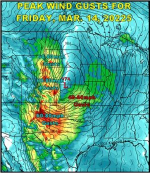
Kansas City, March 11 (World Weather Inc.) – A very intense low pressure center expected to form over the central United States late this week and early in the weekend will have many impacts. A blizzard is expected in the northern Plains, southeastern Canada’s Prairies and the upper Midwest as the storm center taps into cold air moving south from Canada while dragging warm and moist air northward from the southern states. The wind will also stir up dust and sand in the southwestern U.S. Plains reducing visibilities and removing volumes of lingering moisture from the topsoil in some hard red winter wheat areas. The wind will also threaten travel for high profile vehicles, induce power outages and produce property damage.
U.S. Midwest, Southeast, Delta Planting Prospects Favorable
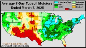
Kansas City, March 7 (World Weather Inc.) – A storm system made its way across the United States earlier this week that brought needed precipitation to a part of the upper Midwest while maintaining or returning wet field conditions to the Delta, southeastern states and parts of the lower eastern Midwest. This week’s rain and snowfall should have been favorable for ensuring favorable early planting moisture for next month, although fieldwork has been on hold in the lower Delta recently because of wet fields. In the meantime, portions of the Great Plains are still quite dry and in need of more moisture. Weather trends in the coming ten days are unlikely bring significant changes with dryness still remaining in parts of the Plains while the lower and eastern Midwest is plenty moist. Parts of the Delta, Tennessee River Basin and interior southeastern states may be a little too wet for a while.
Canada, Europe Impact from Stratospheric Warming To Be Low
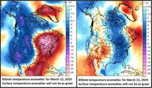
Kansas City, March 7 (World Weather Inc.) – Plenty of hype has been given to the amazing warm up that is suddenly occurring in the stratosphere this week. Stratospheric warming and its potential impact on the polar vortex will be substantial. However, the impact from the current event is going to prove disappointing to the energy trade because the cold air feared to reach into North America and Europe will likely prove to be less intensive and persistent than predicted and the big draw on supplement heating fuel (whether it is natural gas, heating oil or electricity) will probably fail to evolve. Cooling is likely, but the impact will be low.
Spring Is Near; Powerful U.S. Storm Reflects Air Mass Contrast
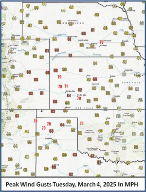
Kansas City, March 5 (World Weather Inc.) – Meteorologically speaking spring began Saturday, but technically spring is still a couple of weeks away. However, an impressive contrast in atmospheric conditions and air masses Tuesday and early today induced quite the windstorm and blizzard conditions in a part of the central U.S. The storm will make it to the Great Lakes region this afternoon and then diminish greatly. Blizzard conditions will continue through the morning in the western Corn and Soybean production region.
Weekly Citrus Weather For Tuesday, March 4, 2025
Kansas City, March 4 (World Weather Inc.) – Florida’s citrus region received little rain during the past week and will remain drier biased during the coming week. Irrigation will be used across the region, though the need for rain will increase later this month. Brazil’s citrus areas were also drier than normal during the past week with little rain on the way through early next week. Citrus yield potentials may be marginally decreased in the driest locations, especially if drier weather persists later this month. Mexico’s citrus areas will also trend mostly dry during the coming week. The need for timely rain is high.
Severe Weather In U.S. Next Week; Stormy Spring Likely
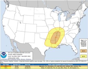
Kansas City, February 28 (World Weather Inc.) – Strong to severe thunderstorms are expected across U.S. Midwest, Delta and Tennessee River Basin next week as a strong contrast in airmass temperatures evolves. Thunderstorms will impact many areas from southern Wisconsin, far eastern Iowa, Missouri, Arkansas and eastern most Texas through the Delta and into the Tennessee River Basin and parts of the lower eastern Midwest. The Storm Prediction Center indicates the greatest risk of severe weather will be in the lower half of Mississippi and Ohio River Valleys Tuesday evening into Wednesday. Damaging wind, hail, excessive rain and local flooding will be possible in association with these storms along with a few possible tornadoes.
U.S. Plains Moisture Deficits Will Not Improve Much In March
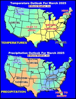
Kansas City, February 28 (World Weather Inc.) – Weather in most of the U.S. Plains during February was not very great leaving moisture deficits in place that may become an issue as the warm season arrives. March is unlikely to bring much change to the region, although a little more rain and snow will fall in Nebraska, northwestern Kansas and northeastern Colorado. Precipitation will remain limited in the northern and southwestern Plains while the lower and eastern Midwest, Delta, Tennessee River Basin and northeastern states are wetter biased.
U.S. Precipitation Will Ease Dryness In “Portions” Of Midwest
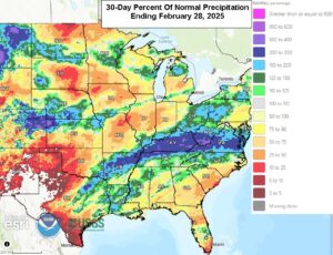
Kansas City, February 28 (World Weather Inc.) – Several areas in the U.S. Midwest and southeastern states saw drought or abnormally dry conditions prevail or evolve in recent weeks as drier than normal weather developed and/or persisted. The Upper Midwest and western sections of the Corn and Soybean Belt, along with southern South Carolina and portions of Georgia, experienced the greatest deviation from normal precipitation. Other locations in the Midwest and southeastern states, along with the Delta, were generally drought-free as timely precipitation occurred in recent weeks. The main production areas will see a good mix of precipitation and dry weather through the end of next week that will help improve the moisture profile in some of the driest locations. However, additional precipitation may be needed in some of those areas and others to fix the dryness. Early-season planting prospects will improve for areas struggling with moisture deficits.
N. America May See Higher Late Season Frost, Freeze Risk
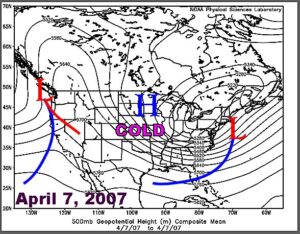
Kansas City, February 27 (World Weather Inc.) – Warm weather in North America this week has provided a great sigh of relief for folks suffering from bitter cold earlier this month; however, additional cold surges are likely this spring. World Weather, Inc. believes other bouts of colder than usual weather are likely after a period of warming like that which is under way now and the impact could be somewhat threatening to winter and earl- planted spring crops later in the year.
Weekly Citrus Weather for Tuesday, February 25, 2025
Kansas City, February 25 (World Weather Inc.) – A disturbance brought much-needed rain to Florida during the past 24 hours. Drought or abnormally dry conditions slowly evolved in recent weeks and the rain will help improve the moisture profile. Drier biased conditions will return during the coming week and net drying is again expected. The combination of irrigation and recent rainfall will still support a good environment for citrus. In Brazil, precipitation was limited in several locations during the past week. Drier-than-normal weather will persist during the coming week and the need for rain will increase later in March. Spotty rain was noted in Mexico’s production areas during the past week. The main citrus areas will trend drier than normal during the coming week and timely rain would be welcome later in March.
U.S. Plains Precipitation Will Remain Limited In Coming Weeks

Kansas City, February 21 (World Weather Inc.) – The moisture profile varies significantly across the main production areas in the United States. The High Plains region is struggling with moisture deficits due to drier biased conditions over the winter season, though parts of the region received significant moisture in November. Waves of precipitation from the Delta and lower Midwest into the southeastern states, along with portions of the Pacific Northwest and California in the past few months resulted in adequate to excessive soil moisture. The areas of greatest concern include the southwestern desert region and a large part of the Great Plains and western Corn Belt due to dryness from August through October and that which has occurred since the beginning of December. There is also some dryness prevailing from Florida to southeastern Virginia. These precipitation anomalies are unlikely to change over the next few weeks.
Southern U.S. Heaving Soil, Livestock Stress Induce Concern
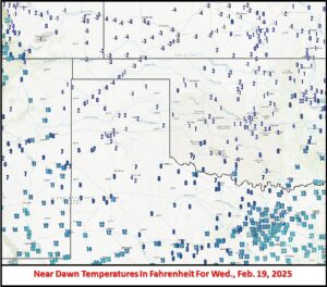
Kansas City, February 19 (World Weather Inc.) – Temperatures have been on a bit of roller coaster ride in the southern Plains, Delta and southeastern states in recent weeks. The environment has sent temperatures well below freezing and then well above freezing and now back well below freezing. The impact has been stressful on livestock while threatening winter wheat. Concern over animal health and some winter crops has risen, although the impact overall may be low. The cycle will continue with bitter cold into Thursday and then much warmer weather this weekend.
Weekly Citrus Weather For Tuesday, February 18, 2025
Kansas City, February 18 (World Weather Inc.) – Several counties in Florida’s citrus region were again mostly dry during the past week. Irrigation was being used across the state to support relatively good conditions for tree and fruit development. The region will see a mix of spotty rain and sunshine during the coming week. Resulting rainfall will be too light to fix moisture deficits and producers will continue to rely on irrigation. In Brazil, several areas in Sao Paulo and southwestern Minas Gerais received limited rainfall during the past week and the outlook calls for continued drier than usual conditions in the next seven days. Greater rain may begin to fall in Sao Paulo during mid- to late-week next week. The main citrus areas will have ample moisture to support new growth, though the need for rain will increase late this month into early March. Mexico’s citrus areas will also have a few opportunities for rain during the coming week that will be beneficial for the citrus that is flowering.
Special Interest Weekend Weather Maps
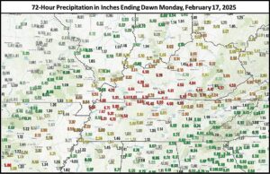
Kansas City, February 17 (World Weather Inc.) – Flooding rain occurred during the weekend as expected from the northern Delta into Kentucky and parts of Tennessee as well as some surrounding areas. Also, during the weekend was the return of brutal cold in the north-central United States and that cold will be expanding and deepening in the central U.S. during the first half of this week. Bitter cold was also returning to Russia and Ukraine, but snow cover should protect most of the crops in that part of the world just like in the U.S.
U.S. Bitter Cold Occurs Over Snow Covered Wheat Areas
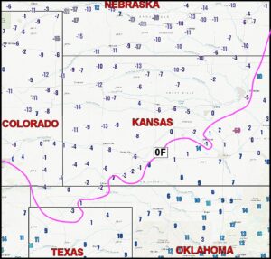
Kansas City, February 13 (World Weather Inc.) – Bitter cold temperatures occurred deeply into the central United States this morning. Most of the wheat produced in the region should not have been vulnerable to damage from this episode of cold because of widespread snow cover. There is still considerable debate over whether serious crop damage occurred in January when bitter cold overspread the same region with limited or no snow cover.
Weekly Citrus Weather For Tuesday, February 11, 2025
Kansas City, February 11 (World Weather Inc.) – Drought and abnormally conditions have expanded across Florida in recent weeks. Irrigation continued to promote a good environment for fruit and tree harvesting and development. The region will have a few opportunities for spotty rainfall during the coming week that will supplement irrigation. Temperatures will remain armer than usual. Brazil’s citrus areas will trend drier than normal during the coming week. No significant impacts are expected, though the need for rain will increase later this month and early March. Veracruz and neighboring locations in Mexico will have several opportunities for rain during the coming week. The precipitation will be welcome for the citrus trees that are flowering or will begin flowering.
La Nina Near Its Second Peak; Weakening Likely
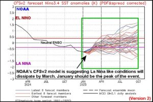
Kansas City, February 11 (World Weather Inc.) – Weak La Nina conditions have had a mixed influence on weather around the world. Some areas, like South America, portions of the United States and Southeast Asia have seen traditional La Nina influences while India, North Africa, southwestern Europe and South Africa have not. This is a classic example of weak La Nina events and the variance has to do with the strength of other prevailing weather patterns. The recent strong rise in the Southern Oscillation Index (SOI) is occurring after another bout of strong easterly trade winds and new upwelling occurred in the eastern equatorial Pacific Ocean. All of these factors are related to a short term strengthening in the La Nina event. The event is just about to peak out and most indicators now suggest weakening will begin in late February and continue throughout March.
2025 Weather Outlook Series: North America Summer
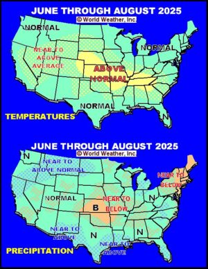
Kansas City, February 7 (World Weather Inc.) – Spring weather, as noted in our second part of this three-part long range weather series for North America, was complicated – to say the least. Either old age is making the art of weather forecasting more complex than it needs to be or we are truly in unique times. Confidence in the spring outlooks for both Canada and the United States is high despite all of the data presented for the spring outlook. Unfortunately, the summer is not going to be much easier because so much of the summer outlook will be dependent on what happens in the spring.
Central U.S., Midwest Snow Next Week To Protect Wheat
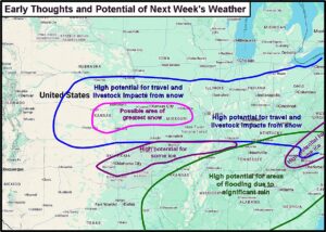
Kansas City, February 7 (World Weather Inc.) – A weather pattern setting up for next week will lead to multiple rounds of rain, snow, sleet and some freezing rain from the central Great Plains into the Midwest and in some more northern areas this weekend into early next week. The precipitation will begin in the eastern Midwest this weekend with some significant snowfall across the Great Lakes region and especially in the northeastern states. Follow up waves of snow and rain will begin in the central Plains Monday into Tuesday and shift east through the lower Midwest Tuesday and Wednesday with a second wave of snow, rain and freezing rain occurring in the same region Wednesday into Thursday. This latter storm system will also produce snow in the Great Lakes region and northeastern states. There is some potential for a third storm to impact parts of the same region in the following weekend. Travel delays and livestock stress are expected, although the snow will help protect winter wheat from threatening cold conditions
Interior SE U.S. Rain Next Week To Bring Relief From Drying
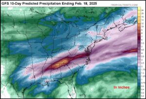
Kansas City, February 7 (World Weather Inc.) – Three and possibly a fourth wave of rain will move through the interior portions of the southeastern United States during the coming week to ten days. The precipitation will bring moderate to heavy rain over the same region repetitively resulting in the saturation of soil, significant runoff and possible flooding. The area to be impacted will be from southwestern Virgin through eastern Kentucky, far northern Georgia and northern Alabama to the northeastern corner of the Delta. Some of that region has been quite dry recently and (outside of the possible flooding) the event may prove to be beneficial for crops in the early spring.
2025 Weather Outlook Series: North America Spring
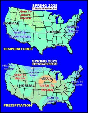
Kansas City, February 6 (World Weather Inc.) – As noted in part one of this 2025 Weather Outlook Series, there is good potential that weather coming into spring 2025 will be drier biased in a portion of the Great Plains, upper Midwest and southwestern desert region into northern Mexico. Canada’s Prairies will come into spring with some hope of improved weather after winter precipitation was favorable and some areas will have significant snow to melt as seasonal warming begins.
2025 Weather Outlook Series: Late Winter
Kansas City, February 3 (World Weather Inc.) – Weather in North America has been dominated by the 22-year solar cycle since 2020. That cycle brought a return to broad-based drought in portions of North America as it has numerous times in the past. The feature was accompanied by a classic multi-year La Nina event from 2020 to 2023 followed by a single year El Nino in 2023 and then neutral ENSO conditions with a La Nina bias in 2024-25. This period of weather also brought on the most prolonged and record strong negative Pacific Decadal Oscillation (PDO) that has occurred from 2020 through today and ocean temperatures were unusually warm throughout the world in the past couple of years.
Weekly Citrus Weather For Tuesday, February 4, 2025
Kansas City, February 5 (World Weather Inc.) – Florida’s citrus region saw temperatures return to seasonable or seasonably warm levels during the past week. Rainfall was limited and will remain limited through early next week. Producers will rely on irrigation for the varieties that are flowering. In Brazil, several citrus areas received significant rainfall during the past week. Farming activity may have been sluggish and drier weather may be needed. Sao Paulo and southwestern Minas Gerais will see a good mix of rain and sunshine during the coming week that will continue to support a good environment for new growth. In Mexico, light rain will often be scattered across the citrus areas in the coming week. The rain will be welcome for the citrus that is flowering or will start flowering later this month.
U.S. Crop Moisture For January 31, 2025: February Outlook
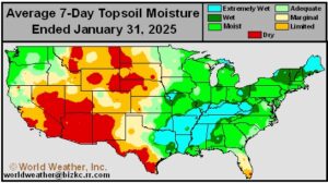
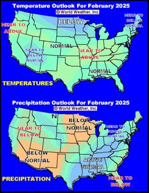
Kansas City, January 31 (World Weather Inc.) – The first month of 2025 is already over…..Amazing! At the end of the month soil moisture was rated well in the Midwest while conditions may be a little too wet in parts of the lower Ohio River Valley, Tennessee River Valley and Delta into northeastern Texas. This latter region of wet biased conditions just received 2.00 to 5.00 inches of rain in the past couple of days and more weather systems like this are expected later in coming days and weeks. In the meantime, soil moisture remains limited in the northwestern, west, central and southwestern Plains as well as the upper Midwest. Changes in these drier biased areas are unlikely to occur anytime soon, despite some light precipitation.
Northern California To Receive Much-Needed Precipitation
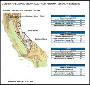
Kansas City, January 29 (World Weather Inc.) – Timely precipitation was noted in portions of California last autumn and early in the winter for much of California. However, drier than normal weather was noted since early December for much of the state, most notably the southern half of the state. Snowpack for the Sierra Nevada is generally lower or much lower than usual for this time of year. Reservoir levels are near or above historical averages and the outlook for the upcoming season is generally good. Timely precipitation would still be welcome in the coming weeks to ensure ideal prospects. The northern half of the state will be unusually wet through the middle of next week. Mountain snowpack will increase significantly and several locations at lower elevations will receive enough rain to bolster soil moisture and water storage levels. The southern half of the state will otherwise remain dry.
US Gulf Coast Snowstorm Shows 1895 Connection to 2025 Spring
Kansas City, January 22 (World Weather Inc.) – Tuesday’s snowstorm along the central U.S. Gulf of Mexico coast was a very impressive event – to say the least. However, it is another good example of how weather is cyclical. The storm was quite similar to the record setting snow event of February 1895. Despite the interesting parallel between the two snowstorms, World Weather, Inc. is much more interested in the dominating weather pattern that brought on these two events because of the possibility that the event can reveal a clue over what is yet to come this winter and spring.
Northwest U.S. Moisture Situation Improves; More Needed
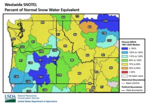
Kansas City, January 24 (World Weather Inc.) – Precipitation in the northwestern United States has improved in recent weeks, although there is still need for more moisture to adequately recharge soil moisture and water reservoirs for use in the spring.
Snowpack in the U.S. Pacific Northwest and northern Rocky Mountains is near to below normal across most of the region with above normal snowpack in the Blue Mountains of Oregon. Water reservoir levels in the Yakima Valley have improved slightly from autumn; however, reservoirs are still low, between 12% and 24% of capacity. Soil moisture has also improved, though there is need for more moisture. Minimal to no precipitation is expected across the crop region in the next 7-days, though a dusting to 3 inches will occur over the northern Rocky Mountains. Longer range outlooks suggest drier biased conditions will prevail through February. If this verifies, more precipitation will be needed to maintain and improve moisture conditions ahead of spring.
Louisiana Sugarcane, Much of South U.S. Cold Damaged
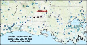
Kansas City, January 22 (World Weather Inc.) – Incredibly cold temperatures occurred this morning in the Deep South of the United States as well as northeastern Mexico. Hard freezes occurred as far south as southern Texas, northeastern Mexico and the entire central U.S. Gulf of Mexico coast causing damage to crops and property. The most damaging conditions were noted in fruit and vegetable areas of southern Texas, northeastern Mexico and in portions of southern Georgia and northern Florida. Sugarcane areas in southern Louisiana experienced the coldest temperatures on record with readings in the single digits Fahrenheit and a couple of extremes near and lightly below zero.
Upper U.S. Midwest Late Winter, Early Spring Bias Remains Dry
Kansas City, January 22 (World Weather Inc.) – Abnormally dry and various levels of drought were noted in the upper U.S. Midwest during the autumn. Weather conditions in recent weeks have not offered much of a change and the trend is expected to prevail, despite some brief periods of precipitation in coming weeks. The odds are quite good that parts of the western Corn and Soybean production region will begin spring drier than usual. Producers will be hoping for better April and May precipitation as time moves along.
Frost, Freezes In South Texas, NE Mexico Tonight
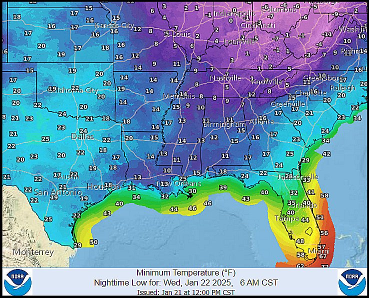
Kansas City, January 21 (World Weather Inc.) – Frost and freeze conditions have already been noted southward into interior southern Texas and along the entire central U.S. Gulf of Mexico coast this morning. The same areas will be impacted again tonight with the cold digging farther to the south through all of South Texas and into northeastern Mexico. An impact on fruit and vegetable crops is expected with some production cut possible for a few crops. Most of the damage to fruit trees and sugarcane is not expected to be very great, but some impacted is expected.
Weekly Citrus Weather For Tuesday, January 21, 2025
Kansas City, January 21 (World Weather Inc.) – Arctic air swept across North America in recent days, dropping temperatures well below normal in several locations. While some of the colder air reached Florida, no significant frost and freezes were noted in citrus country. Colder biased conditions will persist during the next several days for Florida with nighttime lows dropping to the 30s Fahrenheit in northern fringes of citrus country. However, no significant citrus damage is expected. Brazil’s citrus region received rain on a frequent basis during the past week with more on the way during the coming week. Development conditions will remain favorable. In Mexico, arctic air has also promoted colder biased conditions in northeastern portions of citrus country in recent days. Frost and light freezes will occur in portions of Nuevo Leon and Tamaulipas Wednesday morning and may damage a minor amount of crop. Citrus in southern Texas will also be impacted. There is hope that very little of the citrus has started to flower and overall damage should be minimal.
U.S. Bitter Cold To Threaten Sugarcane, Southern Wheat
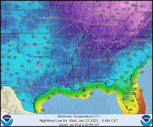
Kansas City, January 20 – (World Weather Inc.) – Bitter cold temperatures occurred during the long U.S. holiday weekend, although the impact on wheat was minimal – at least so far. The coldest temperatures are still forthcoming over the next few nights and there may be some negative impact on lower Midwest, Delta and Tennessee River Basin production areas. However, damage to sugarcane in Louisiana may be more significant.
U.S. Bracing For Blast Of Arctic Air Through Early Next Week
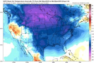
Kansas City, January 17 (World Weather Inc.) – A pool of warmer air spread across portions of North America in recent days, though the warmer period will quickly come to an end this weekend as a blast of arctic air surges southward across much of North America east of the Rockies. Temperatures will plummet well below normal for this time of year, increasing energy demands and potentially stressing livestock. Pockets in Nebraska, Iowa, and neighboring locations will also experience sub-zero degree Fahrenheit readings Monday morning while also having little to no snow on the ground. Winterkill will be a concern and may damage a minor amount of wheat and other crops produced this time of year. Freezes will reach as far south as northern Florida, southern Louisiana and southern Texas, though the coldest air should remain outside the main citrus areas of Florida. Arctic air will shift into eastern North America toward the middle of next week, keeping temperatures below normal across the region, but the last days in January will be warmer.
North America Arctic Air Outbreak To Have Many Impacts
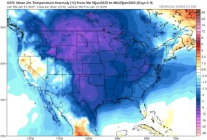
Kansas City, January 14 (World Weather Inc.) – Although an upper-level trough will make its way across eastern North America during the next few days, temperatures will only trend a few degrees cooler than usual for portions of the U.S. and Canada. Warmer air associated with a nearby high-pressure ridge will otherwise spread across a large section of North America later this week, prompting above or well above normal temperatures for several locations. This period of warmer weather will be short-lived as a pool of arctic air is slated to expand across North America this weekend and next week. Areas near and east of the Rockies will gradually see temperatures drop below to well below normal during this time with exceptions for southern Florida, Maine, and eastern fringes of Canada. The cold weather will increase energy demands and may stress livestock. Winterkill will also be a concern in pockets of the northern Plains and Nebraska due to little snowpack and a lack of new snow before the coldest weather.
Weekly Citrus Weather for Tuesday, January 14, 2025
Kansas City, January 14 (World Weather Inc.) – Colder weather was the main story in Florida’s citrus country during the past week. No damaging cold weather was noted, though some locations in the north cooled to the lower 30s Fahrenheit for brief periods of time. The next threat for colder weather will not be until at least next Tuesday. Until then, citrus conditions will remain generally good. Brazil’s citrus regions saw a mix of spotty rain and sunshine during the past week. More frequent and significant rain will occur during the coming week, which will maintain a good environment for new growth. Mexico’s citrus areas received mostly light rain during the past week with periods of spotty rain again occurring in the coming week. Frost will be a concern in Nuevo Leon.
U.S. Northern Plains Will Not See Much Relief From Drought
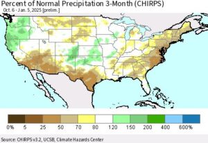
Kansas City, January 10 (World Weather Inc.) – A large section of the U.S. northern Plains trended drier than normal during the past three months. Drought or abnormally dry conditions evolved as a result of the drier biased environment and the need for timely precipitation is high across the region. Much of the region is covered in snow. Some of the snow will eventually seep down into the soil once seasonal warming begins this spring, though current snow totals are too light to offer much relief from the dryness. The region will have a few opportunities for precipitation in the coming days that will bolster snowpack. However, resulting precipitation will remain too light to significantly improve long-term conditions for the moisture profile. The need for significant precipitation will remain high later this winter and early this spring to improve planting prospects for the region.
U.S. Winter Storm Shifting Into Southeastern States
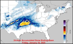
Kansas City, January 10 (World Weather Inc.) – The latest winter storm to impact the U.S. promoted significant snowfall from portions of Texas, Oklahoma, and southern Kansas through the northern Delta to northern Alabama and Tennessee overnight and earlier today. Travel has been and will likely be impacted for the next couple of days with a stressful environment for livestock also possible. Several areas in hard red winter wheat country received enough precipitation to eventually lift topsoil moisture. The winter storm will shift farther east through tonight and end Saturday with impacts from the Delta to the southeastern states, lower Ohio River Valley, and neighboring locations. Tennessee, northern sections of Georgia, Alabama, and Mississippi, and neighboring locations will receive the greatest amount of snow that will likely slow or delay travel. The moisture will otherwise be welcome are several locations are in a drought or abnormally dry.
Winter Storm Brings Local Relief To SW U.S. Plains Dryness
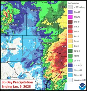
Kansas City, January 10 (World Weather Inc.) – Drought has been prevailing in the U.S. desert southwest for an extended period of time. Drought has not been declared in the southwestern Plains, but some areas have been quite dry since big November rains impacted the region. A winter storm that began in the southwestern U.S. Plains Thursday brought some moisture to a part of the drier areas in the southwestern Plains, but only local relief resulted and there is still need for more moisture.
SE U.S. Cold Should Spare Sugarcane, Citrus From Serious Harm
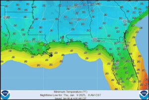
Kansas City, January 8 (World Weather Inc.) – A series of cold air masses continue to pass through the southeastern one third of the United States keeping the region near and south of the Ohio River Valley colder than usual. A winter storm passing through the Delta to the middle and southern Atlantic Coast States Thursday into Saturday will reinforce this trend and maintain some very cold weather in the Gulf of Mexico Coast States. Frost and a few light freezes will occur in Louisiana sugarcane and some northern Florida citrus areas, but the intensity of the cold should stop short of causing a serious threat to 2025 production. Other crops in northern Florida and the southeastern states will be impacted by the cold, although recovery is expected without much concern over future development.