
U.S. Lowest Midwest Relief Next Week To Be Limited
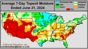
Kansas City, June 21 (World Weather Inc.) – A high-pressure ridge over eastern North America limited rainfall and induced some very warm temperatures in much of the lower Midwest during the past week resulting in net drying. While late-season planting and general fieldwork advanced swiftly in this environment, the need for timely rain is increasing. Little to no rain will fall through the weekend and the continued dryness and warm weather will impact crop development rates and induce some plant stress. Precipitation will remain limited today and Saturday as the ridge remains over eastern North America. The region will have a few opportunities for erratic rainfall and thunderstorms later this weekend and next week as the ridge slowly propagates into western North America. Resulting rainfall will be too light to significantly improve the moisture profile in most areas and net drying will persist, leading to additional crop moisture stress.
U.S. Midwest, Plains Heat To Pressure Summer Crop Yields
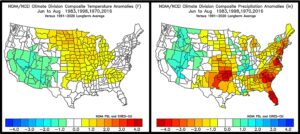
Kansas City, June 21 (World Weather Inc.) – El Nino’s influence on the world is over and the late April through early June wet bias in the U.S. Midwest is gone except in the northwestern Corn and Soybean Belt where the ground is too wet and flooding is likely with the next waves of rain. The return of neutral ENSO conditions will allow North America weather to fall back to being influenced by the lunar (18-year) and 45-day weather cycles with some eventual influence from negative Pacific Decadal Oscillation (PDO), a weak subtropical high pressure system in the Atlantic Ocean and (eventually) La Nina. All of that influence favors a warmer than usual summer with less than usual rainfall in the Great Plains portions of the Midwest and the Atlantic Coast States. Corn and soybean yields, however will be more influenced by temperatures than anything else this summer and the odds favor more heat “at times” than that seen in recent years possibly pressuring those yields slightly below the trend line especially for corn.
U.S. Upper Midwest Wet Bias To Linger Into Next Week
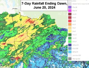
Kansas City, June 20 (World Weather Inc.) – The upper-level high-pressure ridge that brought excessive heat to eastern North America during the past several days will gradually propagate westerly during the coming week. This upper-level pattern brought several waves of rain to the Upper Midwest and bolstered soil moisture to adequate or excessive levels. While the rain was beneficial for long-term corn and soybean prospects, late-season planting and general fieldwork were delayed. Additional rain is likely into this weekend and then the precipitation will become less frequent and less significant for a while, although the region will stay abundantly to excessively wet. The lower and eastern Midwest will not be nearly as wet and dryness will continue a concern.
Tropical Storm Alberto Flooding Portions Of Eastern Mexico
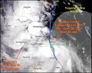
Kansas City, June 20 (World Weather Inc.) – Tropical Storm Alberto was moving inland over east-central Mexico this morning; however, moderate to heavy rain and coastal flooding has been impacting much of eastern Mexico since early on Wednesday. The storm will dissipate over the Sierra Madre later today and tonight, but remnant rainfall will continue in many areas into Friday. In the meantime another disturbance will form in the southern Bay of Campeche that may bring significant rain to the same region late this weekend into Monday exacerbating the flooding.
Weekly Citrus Weather for June 18, 2024
Kansas City, June 18 (World Weather Inc.) – A weak tropical system brought abundant rainfall to portions of Florida during the past week. The rain was generally beneficial and helped improve the moisture profile. Citrus conditions remain favorable across the state. A relatively normal weather pattern is slated for citrus country during the coming week with showers and thunderstorms occurring on a near daily basis. Mexico is bracing for a tropical system that was evolving over the Gulf of Mexico this morning. This disturbance and another disturbance will bring heavy rain to east-central and northeastern Mexico by this time next week. Flooding and landslides will be the main concern, though breezy conditions could damage tree limbs or lead to dropped fruit. Rain will be beneficial for long-term crop conditions and will significantly ease drought. Brazil’s citrus areas were seasonally dry during the past week and will remain mostly dry during the coming week.
U.S., China Soil Moisture Decreases Rapidly
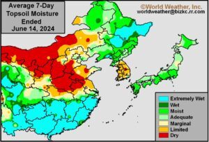
Kansas City, June 14, 2024 (World Weather Inc.) – The latest soil assessment made by World Weather, Inc. today showed rapid drying across the southern United States from eastern Texas through the Delta and into the southeastern states. Portions of the Midwest also experienced a significant decline in soil moisture due to warmer temperatures and a general lack of rain. China experienced some hot temperatures in the past few days while it was dry leading to accelerated drying in the North China Plain and east-central parts of that nation raising the urgency for rain. The U.S. lower and eastern Midwest, interior southern Plains, Delta and southeastern states are expected to continue drying for the next ten days while China may have a few opportunities for showers and less heat.
Parts of U.S. Agriculture To Endure Heat Stress, Drying
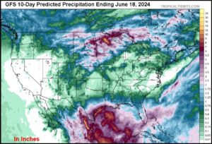
Kansas City, June 14 (World Weather Inc.) – Excessive heat impacted livestock and crop areas from Kansas and southeastern Colorado into western Texas Thursday. The stress was significant, but it only lasted a single day in some areas. Some of the heat will be returning over the coming week. In the meantime, a part of the heatwave will advance to the east passing through the lower and eastern Midwest, the mid-south region and eventually reaching the middle and northern Atlantic Coast States. Temperatures in the 90s Fahrenheit with very high humidity and occasional light wind will be oppressive for livestock and human activity. A general lack of rain is sure to accelerate drying.
Weekly Citrus Weather For Tuesday, June 11, 2024
Kansas City, June 11 (World Weather Inc.) – Florida’s citrus areas received varying amounts of rain during the past week. However, most locations did not receive enough rain to completely fix the drought or abnormally dry conditions that evolved earlier this spring. Irrigation continued to support good citrus development, though drought or abnormally dry conditions further entrenched across the region. A weak tropical system will bring significant rain to the Florida peninsula today and Wednesday with some follow-up rain expected later this week and weekend. The precipitation will improve the moisture profile and maintain a good environment for the citrus. Monsoonal rain will slowly spread across portions of western and east-central Mexico during the coming week. The rain will help improve citrus conditions, most notably in Oaxaca and neighboring locations. Much more rain is needed to completely fix the drought in Mexico. Brazil’s citrus areas were seasonally dry during the past week and will remain dry in the coming week. Maturation and harvesting will continue with few disruptions.
U.S. Midwest Corn, Soybean Short-Term Conditions Good
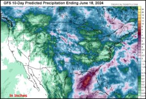
Kansas City, June 7 (World Weather Inc.) – Waves of rain have helped keep soil moisture rated favorably for much of the U.S. Corn and Soybean Belt. Planting is near or slightly ahead of normal for this time of year despite the rainfall. The region will see a good mix of rain and sunshine through the end of next week that will maintain a good environment for establishment and early-season development. Planting will also advance around the periods of precipitation. A high-pressure ridge could then extend over portions of the Midwest during the second week of the outlook, most notably in the eastern Corn and Soybean Belt. The environment will remain generally good for short-term development conditions despite the potential for drier and warmer weather.
Weekly Citrus Weather for June 4, 2024
Kansas City, June 4 (World Weather Inc.) – Warmer-than-normal conditions combined with spotty rainfall in recent weeks promoted aggressive drying in Florida. Drought or abnormally dry conditions were noted in a large section of citrus country despite some rainfall in recent weeks. Irrigation has been applied routinely, but a failing in the development of normal seasonal rainfall is possible over the next few weeks and could perpetuate dryness and raise the dependency upon irrigation for normal tree and fruit development. Dryness could eventually raise concern over fruit sizes and quality. Drought is also prevalent in Mexico’s citrus areas. Drier and warmer than normal conditions during the coming week will continue to promote less than favorable conditions for the citrus. Seasonally dry weather in Brazil will be beneficial for the citrus that is maturing or being harvested.
U.S. Midwest To Receive More Rain; Planting Impacts Possible
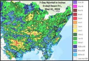
Kansas City, May 31 (World Weather Inc.) – Frequent rainfall continued for the U.S. Midwest during the past week. Planting of the corn and soybeans continued around the rain and progress remains near or slightly ahead of the previous five-year average. An active weather pattern will persist for the Midwest through the end of next week. Rainfall will be enough to keep soil moisture at adequate to excessive levels. Planting and general fieldwork may advance slowly at times or may even be delayed in the wettest fields. Establishment and long-term development conditions will otherwise be favorable for much of the region.
La Nina’s Slow Evolution May Reduce U.S. Dryness Fear
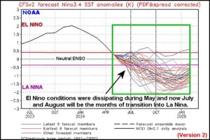
Kansas City, May 30 (World Weather Inc.) – Weather in North America during May deviated from expected precipitation in key crop areas in the United States. The greater than expected rainfall has not only been significant in relation to other years in this lunar cycle, but it is much more fitting of slow transition years from El Nino to La Nina. The latest data from the U.S. National Oceanic and Atmospheric Administration’s (NOAA) Climate Prediction Center has suggested a further delay in the development of La Nina is under way and that, too, supports a less threatening summer outlook for some Midwestern crop areas. Dryness is still probable in a part of the Plains and some Midwestern locations during the middle to latter part of summer, but other areas in the Midwest will likely see timely rain. New research is suggesting drier conditions in the Middle and Southern Atlantic Coast States.
Weak Subtropical High To Keep Many Tropical Storms In Atlantic
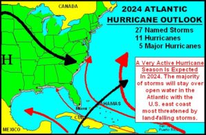
Kansas City, May 29 (World Weather Inc.) – Unusually warm tropical Atlantic Ocean water has been given a lot of press in recent months. All forecasting entities have warned of a high frequency of tropical cyclones in the 2024 season. That does not really help much in preparing for the season, although the fear level has certainly been enhanced by all of the publicity and that should lead to some serious preparation for the season. Having a busy tropical cyclone season is easy to predict, but trying to assess the most favored region for land falling storms is a bit more challenging. World Weather, Inc. believes the U.S. Atlantic coast will be the most favored area for land-falling storms this season. However, Mexico, Central America and the lower Texas coast will also be favored. The central Gulf of Mexico Coast may have the lowest potential for land falling storms if the subtropical high pressure system in the Atlantic is weaker than usual all summer, although it only takes one storm to cause a disaster.
Weekly Citrus Weather For May 28, 2024
Kansas City, May 28 (World Weather Inc.) – Florida’s citrus areas generally remained drier biased during the past week. Dryness is intensifying across the region and the need for rain is increasing. Drier biased conditions will persist during the coming week and aggressive drying will persist. Irrigation will be the primary source for moisture and should support some new growth. Drought or abnormally dry conditions persist in much of Mexico’s citrus areas. Spotty rainfall during the coming week will be too light to improve the moisture profile and concerns for poor development will persist. In Brazil, the southern half of Sao Paulo saw waves of rain during the past week that may have impacted farming activity. Drier weather will return during the coming week and should improve maturation and harvest conditions.
Southwest U.S. Hard Red Wheat May Get Rain Too Late
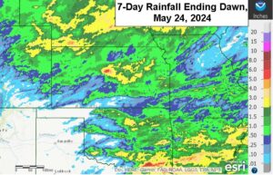
Kansas City, May 24 (World Weather Inc.) – Drought or abnormally dry conditions are ongoing in portions of the central and southern Plains despite some rain during the past week. Hard red winter wheat conditions are variable with some of the crop still rated poor to very poor. Irrigated yields will be high while some of the dryland production areas in the southwest yield poorly. Rain is expected to evolve more frequently beginning Tuesday night into the end of next week and through the following weekend in the high Plains region and that will moisten the soil for summer crops, but many of the dryland winter crops have advanced too far for a serious boost in production because of rain. Some improvement is possible, but much of the rain will have come a little too late for the best plant response. Other wheat production areas in Nebraska, central Kansas and northeastern Colorado will benefit greatly from additional rain.
Some World Weather Anomalies To Subside For A While
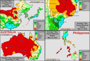
Kansas City, May 23 (World Weather Inc.) – Weather anomalies noted around the world in recent weeks have been quite persistent. The potential for many of these anomalies to breakdown or relax to more typical weather patterns for this time of year is steadily rising and notable changes will occur in the next two weeks. Many of the anomalies; including flooding in southern Brazil, dryness in the North China Plain, excessive rain in southern China, dryness in western Australia, and dryness in the southwestern U.S. Plains along abundant rain in the U.S. Midwest are largely associated with atmospheric confusion resulting from the demise of El Nino. Delayed seasonal rain in the subtropics will also ease in the next couple of weeks.
Weekly Citrus Weather For May 22, 2024
Kansas City, May 22 (World Weather Inc.) – Florida’s citrus areas received varying amounts of rain during the past week. The rain and irrigation continued to support a good environment for the citrus, though dryness is intensifying for several locations due to a lack of significant rain and warm weather. Drier and warmer weather is slated for much of crop country through the middle of next week. Irrigation will continue to be the primary source for moisture. Mexico’s citrus areas remain critically dry and in need of abundant rainfall. The main production areas will have a few opportunities for spotty rainfall during the coming week, but not enough to fix the dryness. Brazil’s citrus areas will see periods of erratic rain in the coming days that may briefly slow the harvest.
Weather Trends Still Favor U.S. Plains, West Midwest Summer Drying
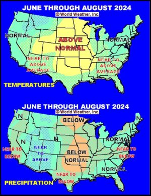
Kansas City, May 21 (World Weather Inc.) – Earlier this year there was much talk about a possible hot, dry, summer in the Plains and western Corn and Soybean Belt based on unusually warm February weather, the quick transition from El Nino to La Nina and a dominating lunar cycle with 6 analog years all suggesting below normal summer rainfall and frequently occurring warmer-biased summers. In recent weeks, the U.S. Corn and Soybean production areas in the Midwest, Delta and portions of both the Great Plains and southeastern states have been wetter than usual. This recent turn of events has raised confusion about the prospects for below normal precipitation and warmer than usual temperatures in the Plains and western Corn Belt. Is this a new trend that will be sustained through the summer or does this reinforce the previous summer forecast?
Weekly Citrus Weather for Tuesday, May 14, 2024
Kansas City, May 14 (World Weather Inc.) – Florida’s citrus region received varying amounts of rain during the past week. Irrigation continued to support good growth, even in areas that received little to no rain. The main citrus areas will only receive light rain during the coming week and will again rely on irrigation. Mexico’s citrus areas were mostly dry during the past week with temperatures warming near or above 100 degrees Fahrenheit on a frequent basis. The environment was stressful for the fruit and trees and abundant rainfall is needed. Northeastern and east-central Mexico into Oaxaca will have opportunities for spotty rain during the coming week, though not enough rain will fall to fix the dryness. Brazil’s citrus areas were mostly dry during the past week and will remain drier biased during the coming week. Production potentials for this season and next season remain lower than usual due to adverse conditions with drying and greening disease.
SE U.S. Turns Wetter Except Florida Where Rain Is Needed
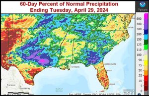
Kansas City, May 10 (World Weather Inc.) – A return of rainy weather has occurred in the southeastern United States in recent days after the topsoil dried out temporarily in late April and early May. Some of the greatest rain has occurred recently with southern Georgia seeing two to three times’ normal rain since April 10. In contrast, much of the Florida peninsula has had very little rain and seen a few days of very warm to hot temperatures resulting in short to very short soil moisture. Additional rain in the southeastern states over the next 10 days will reach above 2.00 inches. Portions of southern Mississippi to southern Georgia may see up to 5.50 inches of cumulative rain, which may create a flooding risk due to preexisting wet conditions in the region. Florida is expected to see some relief with 1.00 to 1.70 inches of rain expected in the next 10 days, though more consistent precipitation will be needed to fully replenish soil moisture.
U.S. Hard Red Wheat Will Receive Much-Needed Rain
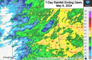
Kansas City, May 9 (World Weather Inc.) – Hard red winter wheat conditions are highly variable across the U.S. central and southern Plains. Drought or abnormally dry conditions are ongoing in portions of central and western Kansas, eastern Colorado, and western Oklahoma despite some recent rainfall. Several areas are reporting poor or very poor wheat conditions, though there is still time to improve development before crops start to mature. An upper-level low-pressure center will become cut-off from the main upper-air flow and will help promote erratic rainfall across the main crop areas Friday into early next week. Another disturbance will likely generate more rain toward the middle of next week. The waves of rain will improve the moisture profile in much of hard red winter wheat country and should support better late-season development. Crops in the driest fields may receive enough rain to improve overall conditions despite rainfall being too light to end drought.
World Wheat Weather For May 8, 2024
Kansas City, May 8 (World Weather Inc.) – Wheat conditions have been a little challenging in recent weeks and months, but despite the concerns it is still hard to kill small grains with adverse weather. Freezes have recently impacted Russia and will soon impact both Russia and Ukraine again with at least some concern over temporary damage. Flooding is still a concern for Brazil planting which is on hold until late this month. Canada’s Prairies, in the meantime, has just finished its best two-week period of rain seen in years improving planting moisture for spring cereals. China wheat remains in good shape as is most of Europe while North Africa continues to struggle with dryness. There are also a few farmers worried about dryness in Western Australia.
Beneficial U.S. Pacific N.W. Rain Misses Central Washington
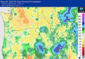
Kansas City, May 8 (World Weather Inc.) – A recent rain event in the U.S. Pacific Northwest brought up to 2.50 inches of moisture to portions of northeastern Oregon and southeastern Washington while missing central Washington and north-central Oregon where dryness remains. In the next 10-days, dry conditions are expected to persist in central Washington. On top of this, unseasonably hot temperatures in the 80s and lower 90s are expected to develop this weekend, which will amplify evaporation and intensify drying. More rainfall will be needed in coming weeks to alleviate dryness in central Washington.
Weekly Citrus Weather for May 7, 2024
Kansas City, May 7 (World Weather Inc.) – Several areas in Florida received spotty rainfall on a frequent basis during the past week. The rain was beneficial for developing fruit and yet briefly disruptive for some harvesting. Drier weather will return during the coming week and should promote more aggressive harvest conditions. Irrigation will continue to be run and maintain a good environment for citrus development. In Brazil, seasonally dry weather evolved during the past week with at least another week of dry weather expected. Maturation and early-season harvesting will advance swiftly. Mexico’s citrus areas will remain drier biased during the coming week despite some spotty rain in the east. Abundant rainfall is still needed across the country to support more favorable production potentials for the upcoming season.
U.S. Weather To Transition Late This Month
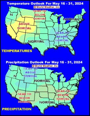
Kansas City, May 2 (World Weather Inc.) – U.S. weather has been wetter than expected in recent weeks and the trend will continue for another week to ten days. The wet bias is putting moisture into the soil that will be fed back into the atmosphere during the warmer days of late May and June. The moisture feedback will help keep the early summer ridge of high pressure weaker than once feared and that will help the month of May be a more favorable month of weather in the United States and Canada. The trend for warmer and drier biased conditions in June and July has not been changed.
Weekly Citrus Weather for May 1, 2024
Kansas City, May 1 (World Weather Inc.) – Florida’s citrus region was dry or received limited rainfall during the past week. Irrigation was the primary source for moisture and continued to support good development conditions. Similar conditions were expected during the coming week. Brazil’s citrus areas were seasonally dry during the past week with dry weather continuing during the coming week. Early-season maturation and harvesting will advance with few disruptions. Dryness persists across Mexico’s citrus areas despite some spotty rainfall. East-central and northeastern Mexico will again see periods of erratic rain during the coming week, though resulting rainfall will be too light to significantly improve the moisture profile.
West-Central U.S. High Plains To Miss Out On Significant Rain
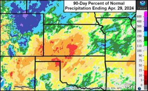
Kansas City, April 30 (World Weather Inc.) – Portions of central and southwestern Kansas and areas west into southeastern Colorado have consistently missed precipitation in recent weeks. Some areas to the south into a part of the Texas Panhandle have also been a little dry. The need for rain is steadily increasing to support dryland wheat development and spring planting and early crop growth. Continued dryness may start to reduce winter crop production potentials in the driest locations. The driest areas will have a few opportunities for erratic rainfall during the coming week that may marginally increase soil moisture; however, the rain will be too light to support long-term crop conditions and follow up precipitation will be a must. Precipitation will remain limited during the second week of the outlook.
U.S. Midwest, Delta Planting Delays To Prevail As Rain Continues
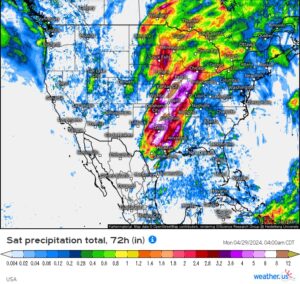
Kansas City, April 29 (World Weather Inc.) – Strong storms and heavy rain pounded portions of the U.S. Midwest and eastern sections of Texas and Oklahoma over the weekend. Flash flooding occurred in the wettest areas of Texas, Oklahoma, Missouri, and Illinois while damaging winds, hail and tornadoes were noted in eastern Nebraska, western Iowa, and portions of Kansas, Oklahoma, and Texas. The rain was welcome for areas still dealing with drought or abnormally dry conditions. However, fieldwork was brought to a halt and there will not likely be much opportunity for fieldwork in the coming week to ten days as more rain evolves. There is some potential that recently planted crops may have to be replanted. The need for drier weather will increase significantly later this month to expedite planting and reduce concerns for lowered production.
Central U.S. Expecting Strong Storms; Fieldwork Impacts Likely
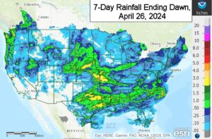
Kansas City, April 26 (World Weather Inc.) – Several areas in the U.S. Plains, Midwest, and Delta will see waves of rain and storms through early next week as disturbances track over central North America. Strong to severe storms are likely from Oklahoma, northeastern Texas, and Kansas into Missouri, Iowa, eastern Nebraska, and neighboring locations today and this weekend. Several inches of rain will fall in several areas that are experiencing drought or abnormally dry conditions and significant improvements are expected. Planting and general fieldwork will not advance well in the central Midwest, but is expected to proceed around showers in the eastern Midwest, Tennessee River Basin, southeastern states and the west-central and southwestern high Plains. Some flooding is expected this weekend and early next week.
U.S. Cooling Next Week Could Bring Back Frost, Freezes
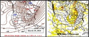
Kansas City, April 26 (World Weather Inc.) – North America weather continues to cycle through a repeating weather pattern and that may culminate in the return of colder than usual temperatures for a few days late next week and into the following weekend. Frost and freezes may accompany the cool off for the northern Plains and Midwest, although the colder conditions do not look very threatening to crops at this point in time.
Weekly Citrus Weather For April 23, 2024
Kansas City, April 23 (World Weather Inc.) – Much of Florida’s citrus region received light precipitation or was mostly dry during the past week. Precipitation will remain limited for at least another week and irrigation will continue to be run across the region. Citrus conditions will remain good despite the lack of rain. Brazil’s citrus region received varying amounts of rain during the past week with areas in western and northern Sao Paulo and southwestern Minas Gerais trending mostly dry. Seasonally dry weather is slated for much of the region in the coming weeks. Net drying is slated for most locations, though there will be some moisture to support new growth. In Mexico, the eastern production areas received mostly light rain during the past week with more on the way in the coming days. Drought or abnormally dry conditions will persist and the need for abundant rain will remain high.
U.S. Midwest Rain Falls In Line With Drier, Warm Summer
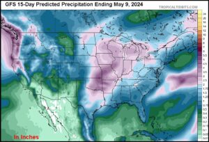
Kansas City, April 23 (World Weather Inc.) – Rain earlier this spring was abundant to excessive in parts of the Delta and southeastern states. A part of the eastern Midwest was too wet in late March and early April and now central and some western Corn and Soybean Belt production areas are expected to become too wet with a series of storm systems slated over the next ten days. Despite the moisture abundance and expected delays to spring planting, the wetter bias seen so far this spring falls right in line with weather patterns in the past that supported a drier and warmer bias for the Plains and western Corn Belt during the late spring and summer.
U.S. Midwest Rain Will Slow Corn, Soybean Planting Rates
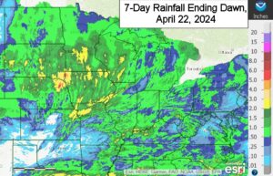
Kansas City, April 23 (World Weather Inc.) – Recent precipitation has been occurring often enough to slow some of the farming activity in the U.S. Midwest and this trend will continue this week before a more dramatic increase in rainfall takes place next week. Farmers will be taking a risk of having some fields washed out if they rush into planting this week ahead of the greater rain that may fall next week. Producers are already eying the second week of May for the big push in fieldwork after the slow start. The next ten days to two weeks of rain in the western Midwest is liable to further reduce drought in the western Corn and Soybean Belt and add moisture for feedback moisture into the atmosphere in late May when a high pressure ridge begins to influence the region.
Weekly Citrus Weather for April 16, 2024
Kansas City, April 16 (World Weather Inc.) – Northern sections of Florida’s citrus region received timely rain during the past week while areas farther south received little to no rain. Citrus conditions were generally favorable due to frequent use of irrigation. The region will trend drier biased during the coming week and producers will again rely on irrigation. Brazil’s citrus areas received varying amounts of rain during the past week. Sao Paulo and southwestern Minas Gerais will trend drier than normal during the coming week, though spotty rainfall will continue during the next few days. Citrus development conditions will remain generally favorable. However, production losses are still expected this season. Many areas in eastern Mexico will see rain potentials increase during the coming week. The rain will be welcome and may marginally improve citrus conditions. Much more rain will be needed to break the drought.
Eastern Midwest, Delta Too Wet And More Rain Coming
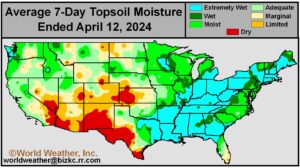
Kansas City, April 12 (World Weather Inc.) – Weather will vary significantly across the U.S. through the end of next week with periods of much warmer and much colder weather, rain and storms, and breezy conditions. The severe temperature swings will likely impact development rates for winter grains and a few early-planted summer crops. Yield impacts will be minimal. The temperature swings and breezy conditions may also stress livestock. Early-season planting in the Midwest will also be impacted with more prolonged delays in getting into some eastern and northwestern Midwest fields due to wet conditions and colder temperatures later next week and into the following weekend.
Washington Apple Bloom Should Escape Damage In Cool Spell

Kansas City, April 11 (World Weather Inc.) – A succession of three deep troughs of low pressure will be moving through British Columbia and the U.S. Pacific Northwest during the next ten days dropping temperatures low enough for mountain snow to fall and raising the potential for nighttime frost and freezes “if” the sky cover clears off. Most winter crops will be unaffected by the cold weather, but some of the region’s flowering fruit trees could be seriously impacted if everything goes exactly wrong. Sixty percent of the apples produced in the United States come from Washington State and with flowering getting under way there is “some” concern over the fate of that crop. Cloudiness will be the crops’ friend.
Southeast U.S. Flooding May Lead To Replanting
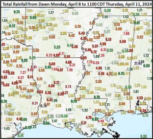
Kansas City, April 11 (World Weather Inc.) – An impressive two-day rain event that moved from eastern Texas through the middle Delta to northern Florida and southern Georgia has proven once again that the atmosphere is still fully capable of producing excessive rain just like it has in the past. More flooding is likely to occur over a larger part of North America in coming years as we move away from this 22-year solar cycle biased for drought and weather extremes. In the meantime, the cleanup from all of the flooding and severe weather that occurred this week is under way. Some agricultural areas will have to replant, due to the severity of flooding especially in low-lying areas.
Texas Panhandle, Northern West Texas Benefit From Rain
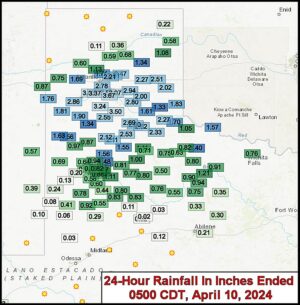
Kansas City, April 10 (World Weather Inc.) – A storm system moving from the southern U.S. Plains through the Delta Tuesday and overnight brought some welcome rain to wheat, corn, sorghum, cotton and livestock areas of the Texas Panhandle, western Oklahoma and parts of West Texas. The moisture was great in bolstering topsoil moisture after recent drying and warm to hot weather. The southwestern dryland counties of West Texas, however, failed to get much moisture and remain quite dry. Wheat benefited from the moisture immediately and future planting in the region will also benefit from the moisture.
U.S. Delta Flooding Rain To Impact Fieldwork
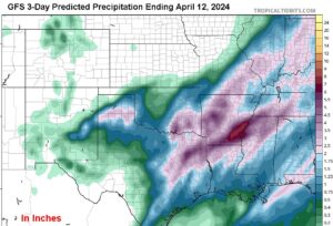
Kansas City, April 9 (World Weather Inc.) – Waves of rain have returned to the U.S. Delta overnight and will continue today with some impressive amounts expected by the end of the day Wednesday. Several strong to severe thunderstorms are also expected in the rainy pattern. Most of the Delta is already saturated or nearly saturated with moisture and another several inches of rain expected over the next two days will lead to flooding. Spring and summer crop planting is underway across the region and there is potential that some damage will occur to previously planted rice and corn and new delays to fieldwork are anticipated as well. Little follow-up rain is expected Friday into early next week, which will give the region a chance to dry down so that fieldwork can resume.
Weekly Citrus Weather For Tuesday, April 9, 2024
Kansas City, April 9 (World Weather Inc.) – Florida’s main citrus areas generally received light amounts of rain during the past week. The region relied on irrigation to maintain a good environment for fruit setting and general development. Other than a few light showers during the next few days, rainfall will remain limited through early next week. The need for irrigation will continue. In Brazil, the main citrus areas generally received enough rain to support good development. Most locations outside portions of north-central and east-central Sao Paulo will receive additional rain during the coming week that will continue to promote good citrus conditions. Production is still expected to be lower than usual due to greening disease and harsh weather earlier in the season. Mexico continues to struggle with dryness and there is not a good opportunity for rain for at least the next seven days.
Wild Weather Coming; Batten Down The Hatches
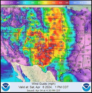
Kansas City, April 5 (World Weather Inc.) – Spring 2024 is shaping up like a more traditional spring in which contrasting air masses collide to induce some wild weather gyrations. It has been a few years since severe weather outbreaks were numerous in the spring, but 2024 is likely to change that trend. There have already been a few events of severe weather including strong wind speeds, severe thunderstorms, hail, damaging wind, tornadoes and wildly swinging temperatures. All of these conditions are expected in this coming week and damage is expected.
Weekly Citrus Weather for April 2, 2024
Kansas City, April 2 (World Weather Inc.) – Florida’s citrus production region generally received light amounts of rain during the past week. Irrigation was run as-needed and continued to support a good environment for fruit and tree development. Rainfall will again be limited during the coming week and the need for irrigation will remain high. Brazil’s citrus areas received rain during the past week that helped maintain relatively good citrus conditions. Greening disease and adverse conditions earlier in the growing season continue to promote lower than normal yields. In Mexico, the main citrus areas were again dry or mostly dry during the past week. Little to no rain is expected during the coming week and drought will likely intensify.
Weekly Citrus Weather for March 27, 2024
Kansas City, March 27 (World Weather Inc.) – A combination of rain and irrigation continued to support a good environment for Florida’s citrus during the past week. Many groves reported fruit setting. The region will trend drier biased during the coming week. Irrigation will be relied upon across the state and will continue to promote a good environment for the citrus. Brazil’s citrus areas received significant rain during the past week with more on the way during the next seven days. The region will have ample moisture to support aggressive growth. The main concern will continue to be citrus greening that is expected to lower yield potentials. In Mexico, portions of east-central and northeastern Mexico received light to moderate amounts of rain during the past week. Drought or abnormally dry conditions remain prevalent in much of crop country. Dry or mostly dry weather is slated for the main citrus areas during the coming week. Dryness will likely intensify.
West Texas Sees Excessive Wind, Low Humidity Sunday
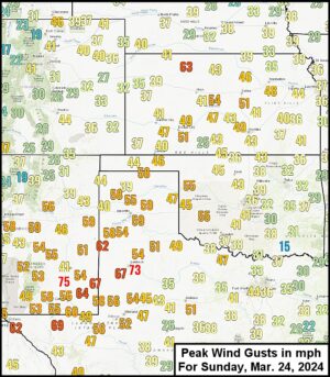
Kansas City, March 25 (World Weather Inc.) – West Texas endured another bout of excessive wind, warm temperatures and very low humidity Sunday. The drying wind was expected and there was concern about the potential for more fires in the region. Agricultural areas lost some more soil moisture after getting a little rain last week. Some blowing dust and sand occurred, although it was not as serious at that of earlier this year after a lengthy period of dry weather. The event raised the need for more rain and yet the next ten days will be dry biased.
Upper U.S. Midwest Moisture Boost To Come With A Price
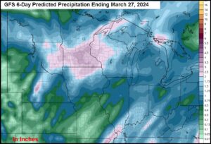
Kansas City, March 21 (World Weather Inc.) – As noted late last week, relief will occur to dryness in the upper Midwest and the eastern northern U.S. Plains during the next five days. The moisture, however, will come with a price as excessive wind develops this weekend across the Great Plains causing blowing dust and inducing some structural damage as well as threatening high profile vehicles traveling across the region. There will also be excessive snow and blowing snow in the upper Midwest with road closures and a serious threat to livestock due to snowfall that will vary from 8 to 20 inches and locally more. The moisture boost will be ideal for use later this spring, but in the meantime, commerce will be disrupted. Power Outages are likely and transportation may come to a standstill in some areas.
Weekly Citrus Weather For March 19, 2024
Kansas City, March 19 (World Weather Inc.) – Florida’s citrus region was mostly dry during the past week. Blooming and development conditions were generally favorable as irrigation was used across the state. A disturbance will bring timely rain to the region later this week that will help bolster soil moisture. Hail and strong wind speeds cannot be ruled out and may damage fruit or limbs, though overall production impacts should be minimal. In Brazil, the main citrus areas received enough rain to maintain generally good citrus development this past week. More significant rain is expected during the coming week and should help improve soil moisture. The need for abundant rainfall remains high in order to support a better outlook for the upcoming season. Portions of east-central and northeastern Mexico will receive some rain during the coming week that will alleviate a minor amount of dryness. However, much more rain is needed across the main citrus areas to support more favorable citrus development.
Tennessee River Basin Freezes Hard Overnight
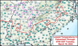
Kansas City, March 19 (World Weather Inc.) – A potent, fast-moving, very cold airmass dropped through the eastern United States Monday afternoon and night forcing temperatures well below freezing this morning deeply into the mid-south region. Hard freezes occurred in the Tennessee River Basin and northern Delta this morning as well as the lower Midwest while light freezes occurred far to the south in southern Mississippi, southern Alabama, central Georgia and he western Carolinas. Damage to fruit and vegetable crops was most significant, but some winter wheat injury was suspected as well.
Interior U.S. Southeast To Be Quite Cold Tuesday Morning
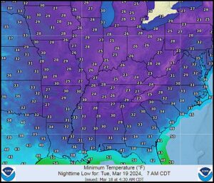
Kansas City, March 18 (World Weather Inc.) – Very cold temperatures were dropping through the north-central United States this morning. Lowest temperatures in the upper single digits and teens Fahrenheit have occurred in the northern half of the Plains with teens and 20s in the upper Midwest. The cold is expected to plunge through the Midwest to the southeastern states today and tonight. Frost and freezes are expected in most areas from the Midwest to the interior Gulf of Mexico Coast states and interior parts of the Carolinas Tuesday morning. Some damage to fruit trees and wheat is expected, although permanent losses to wheat production should be highly localized.
U.S. Crop Areas Moisten From Midwest To Delta, SE States
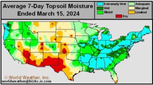
Kansas City, March 15 (World Weather Inc.) – U.S. soil moisture increased across the Midwest, Delta and portions of the southeastern states this past week due to a little more active weather. Soil moisture is still low in the Great Plains and portions of the northwestern Corn and Soybean Belt where the past 30 days of precipitation has been well below average. There is need for greater moisture in the Plains and western Corn Belt while areas to the east are plenty moist and could trend wetter – especially late this month.
U.S. Crop Areas May Face A Few Threatening Freezes
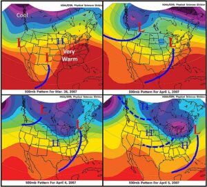
Kansas City, March 14 (World Weather Inc.) – A recently identified 45-day weather cycle has raised the potential for colder weather in mid-April that could be a threat to some early developing winter wheat in the mid-south, southeastern states and possibly a few areas in the central and southern Plains. It is much too soon to give this potential much attention, but it is worth mentioning because of the more advanced condition of crops throughout the southern U.S. Wheat is greening in the central Plains and across the lower Midwest, but development is becoming more aggressive in the Delta and southeastern states as well as a portion of the southern Plains. A first surge of cold air is expected next week that may bring frost and freezes to the Tennessee River Basin.
Weekly Citrus Weather For March 12, 2024
Kansas City, March 12 (World Weather Inc.) – Periods of rain were again noted in Florida during the past week. The environment remained favorable for citrus that is blooming, setting fruit and developing. Drier-than-normal weather will evolve during the coming week, increasing the need for irrigation. Harvesting will advance with few disruptions. In Brazil, Sao Paulo and southwestern Minas Gerais will trend warmer and drier than normal during the coming week. Daytime highs could climb above 100 degrees Fahrenheit at times in western Sao Paulo, which could stress trees and impact some of the fruit. East-central and northeastern Mexico will have an opportunity for much-needed rain later this weekend and early next week. However, much of Mexico will need much more precipitation to completely fix the moisture deficits.
Western Corn Belt Drought Will Likely Persist In March
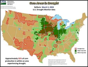
Kansas City, March 8 (World Weather Inc.) – Drought and dryness of varying degrees of significance continues in portions of the U.S Midwest and as spring approaches the removal of drought will become more important especially if summer is going to have a drier and warmer than usual bias. Iowa is experiencing some of the more significant drought while several areas in Wisconsin, Minnesota, Missouri, and eastern Nebraska are also struggling with significant dryness. Abnormally dry conditions have started to spread across portions of the eastern Midwest as well. A disturbance will promote significant rainfall for portions of the eastern Corn Belt today into Saturday with some follow-up rain later next week. Rainfall will be enough to marginally bolster soil moisture and may eliminate abnormally dry conditions in several locations; however, the western Midwest will remain drier biased into the end of next week. Precipitation potentials will not improve significantly during the second week of the outlook. The need for timely rain will increase heading into late March and early April to support more favorable corn and soybean planting prospects.
Confidence Rising Over Quick El Nino To La Nina Transition
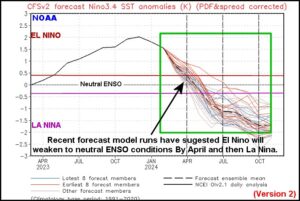
Kansas City, March 8 (World Weather Inc.) – The U.S. National Oceanic and Atmospheric Administration’s (NOAA) CFSv2 ENSO forecast model has been predicting a rapid transition from El Nino to La Nina this year. World Weather, Inc. has been cautious in buying into the forecast for La Nina by June because of the model’s poor track record in predictions made in January for periods more than three months into the future. However, the model has held up well in recent weeks and continues to suggest with a high level of consistency an El Nino to La Nina transition between now and July. In the past, there has been a tendency for quick El Nino to La Nina transitions to result in a significant decline in central U.S. precipitation and rise in temperatures during the summer. There is potential for that again this year.
U.S. Southeast To Receive Rain; Localized Flooding Possible
Kansas City, March 7 (World Weather Inc.) – The ground is saturated with moisture across a large section of the southeastern U.S. Waves of rain were noted across the region during the past week that helped lift soil moisture in most locations outside portions of southern Georgia. The wet weather bias will persist for at least the next seven to ten days with several more inches of rain expected from northern sections of Alabama and Georgia into South Carolina. The additional rain will likely promote localized flooding in the wettest locations. Areas that will potentially be impacted by flooding are not major winter crop producers. However, continued precipitation into the latter part of March could slow early-spring fieldwork. The region should have ample moisture to support favorable early-season establishment for the summer grains, oilseeds, cotton, and other crops after a period of drying evolves.
U.S. Hard Red Winter Wheat Would Benefit From Rain
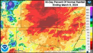
Kansas City, March 6 (World Weather Inc.) – Unusually warm temperatures in recent weeks across the central United States have brought winter crops out of dormancy from parts of Kansas to Texas while drying the soil. Crop development has been slow because of periodic nighttime freezes and dryness. The production potential for wheat this year is much improved over that of last year because of better establishment and previous precipitation events, but the region is in need of some rain or snow to help ensure the best development potential this early spring. Rain will scatter across parts of the region later today into Friday as a strong disturbance passes over the region. Light rain will also be possible toward the middle of next week. Every bit of the precipitation will be welcome, though amounts may be too light in some areas to significantly improve long-term soil conditions. Additional precipitation will be needed soon.
Weekly Citrus Weather For March 5, 2024
Kansas City, March 5 (World Weather Inc.) – A combination of rain and irrigation continued to support a good environment for Florida’s citrus during the past week. The region will again see a good mix of rain and sunshine during the coming week with temperatures trending slightly above normal. Citrus conditions will remain favorable state-wide. In Brazil, many areas in Sao Paulo and southwestern Minas Gerais dried down during the past week due to mostly dry and warm weather. More frequent rainfall will occur during the coming week and should restore soil moisture to more favorable levels. Production potentials remain lower than normal for the upcoming season, primarily due to citrus greening. Mexico’s citrus areas again received little to no rain during the past week. Drought or abnormally dry conditions persist and the need for abundant rain remains high. Very little rain is slated for much of citrus country in the coming week.
U.S. Wheat Damage From Bitter Cold Should Be Low
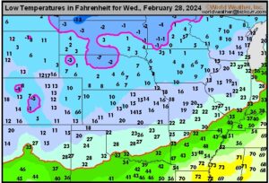
Kansas City, February 28 (World Weather Inc.) – An arctic airmass advanced across central North America overnight, dropping temperatures below zero degrees Fahrenheit in portions of the northern Plains and as far south as northern Nebraska overnight. Several areas in South Dakota, Minnesota, northern Nebraska, northwestern North Dakota, and northeastern Montana were snow-free or had little snow on the ground as warm weather preceded the cold spell. Winterkill was possible for the snow-free areas, which represent a minor amount of the overall winter wheat produced in the U.S. While minor production losses will be possible in areas hit hardest by the bitter cold, overall production potentials will remain mostly unchanged. There is no significant threat for damaging cold through early next week, though another arctic airmass could start to shift into the northern Plains toward the middle of next week. In the meantime, dryness remains a concern for portions of the Plains and western Midwest.
Central U.S. Summer 2024 Has Potential To Be Hot
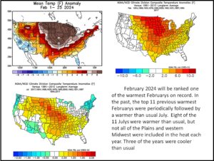
Kansas City, February 28 (World Weather Inc.) – February 2024 is likely to be a record warm month for many areas in North America, including parts of the Midwest and northern Plains. The last time February was so anomalously warm in the north-central United States was in 2017 which led World Weather, Inc. into a search for associations between record warm weather in the Midwest and northern Plains and other anomalous weather during the year. One of the associations found back then was an association between the top warmest Februarys and a tendency for July to be warmer than usual in a part of the central U.S. World Weather, Inc revisited that research recently because it may help to raise the potential for a warmer than usual summer which is already being suggested by the lunar cycle, La Nina and possibly by the remnants of the Hunga Tonga Volcano still stuck in the stratosphere making the world quite warm.
Weekly Citrus Weather for Tuesday, February 27, 2024
Kansas City, February 27 (World Weather Inc.) – Florida’s citrus region only received light rain during the past week. Irrigation was run as-needed and continued to support a good environment for crops. The region will have more opportunities for erratic rainfall during the coming week that will supplement irrigation. Citrus conditions will remain generally good. In Brazil, the main concern for the upcoming crop remains the high prevalence of citrus greening disease. The region received enough rain during the past week to support aggressive growth. Lighter-than-usual rainfall is slated for Sao Paulo and southwestern Minas Gerais during the coming week that will promote net drying, though most groves will still have sufficient moisture to support normal development. Mexico’s citrus areas were dry during the past week and will again trend mostly dry through early next week. The need for abundant rainfall remains high across the country.
U.S. Pacific Northwest Winter Wheat Greening Possible
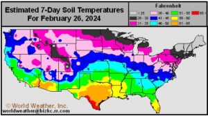
Kansas City, February 27 (World Weather Inc.) – Recent temperatures in the mid-40s to low 60s Fahrenheit in the U.S. Pacific Northwest have caused soil temperatures to warm. Some greening of winter wheat is possible as temperatures are expected to continue fluctuating between the 40s and 60s. Drier biased conditions have been present in portions of the crop region; particularly in the central Washington and northern Oregon. Between 0.10 and 0.40 inch of precipitation is expected in total for the next 7-days in central Washington, which will amplify the need for further moisture to support developing crops
Unusual Warmth Raises Soil Temps, Wakes Up Wheat
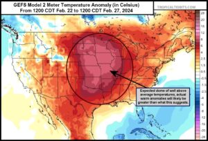
Kansas City, February 21 (World Weather Inc.) – An unusually warm February in the United States continues. Temperatures are expected to warm further in the central part of the country within the next five days which will lead to greater soil temperatures and more greening of winter crops especially in the central and southern Plains. The warmth will then be interrupted by a quick surge of unusually cold air in the middle portion of next week before unusual warmth builds back into the central U.S. in early March.
U.S. Plains, Western Midwest Winter Wheat Prospects Good
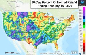
Kansas City, February 16 (World Weather Inc.) – Hard red winter wheat county in the central and southern U.S. Plains remains in much better shape compared to recent past years. Timely precipitation last autumn and over the winter has improved or erased drought that plagued the region earlier this decade. Prospects for wheat are favorable heading into the spring, not only in the central and southwestern Plains, but in the Midwest, as well. The Plains and western Corn and Soybean Belt will trend dry or mostly dry through the end of next week with limited precipitation expected during the last days of February. Wheat prospects will remain favorable as long as timely rain occurs in March. The eastern Midwest will see a mix of precipitation and sunshine in coming weeks that will keep soil moisture near current levels and maintain good wheat development prospects.
More Moisture Needed in Northern U.S. Following Snow Event
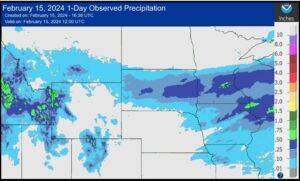
Kansas City, February 15 (World Weather Inc.) – A recent precipitation event brought between 2 to 6 inches of snow to areas of southern Montana, South Dakota, into southern Minnesota. While the precipitation was welcome, more precipitation will be needed in the coming weeks as drying soil conditions and drought persist in many areas of the crop region. In the next 10-days, another 0.10 to 0.40 inch of liquid equivalent precipitation is expected across much of the region, though more precipitation will be needed to alleviate dry soil and drought conditions before planting begins in April.
U.S. Spring, Summer Weather 2024 – A First Look
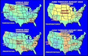
Kansas City, February 14 (World Weather Inc.) – Years of drought in North America may be drawing to a close, although conditions in the late spring and summer 2024 could turn out dry once again and warmer biased. There is potential for a final hurrah in this series of drought years that began in 2020. Some timely rain is expected during the spring, but a bout of heat and dryness may come around during the late spring and early summer that could quickly turn around a favorable moisture profile and create some stress. This pattern shows up in the lunar (18-year) cycle and could be enhanced by La Nina if it develops this year. There is still concern about the lingering effects of the Hunga Tonga Volcano to enhance a warmer temperature bias that is already expected this year.
Weekly Citrus Weather for Tuesday, February 13, 2024
Kansas City, February 13 (World Weather Inc.) – Florida’s citrus region was dry or mostly dry during the past week. Irrigation was run across the region and continued to support a good environment for fruit and tree development. A disturbance will bring varying amounts of rain to Florida this weekend that will supplement irrigation and maintain a good environment for the citrus that is developing and blooming. In Brazil, rainfall varied with many areas only receiving light rain. Precipitation potentials will increase in the coming days and should restore soil moisture to more favorable levels across citrus country. Mexico’s production areas were mostly dry during the past week. A disturbance will promote more widespread rain later this week and weekend, which will chip away at some of the dryness. Much more rain will be needed to completely fix the moisture deficits.
U.S. Delta, Southeast Will Have Abundant Moisture For Planting
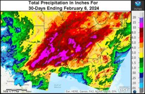
Kansas City, February 6 (World Weather Inc.) – Despite ongoing drought in the Delta and Tennessee River Basin recent rain has been substantial and has saturated the topsoil in many areas. Additional rain expected in the coming ten days will maintain wet field conditions and may lead to localized flooding. The southeastern states are more favorably moist, but they, too, will receive additional rain setting the stage for favorable spring planting conditions once warming kicks in to raise drying rates between storms.
Weekly Citrus Weather For February 6, 2024
Kansas City, February 6 (World Weather Inc.) – Florida’s citrus country generally received light rain during the past week. Irrigation was run on a frequent basis and continued to support a good environment for tree and fruit development. The region will be drier biased during the coming week. The need for irrigation will remain high. In Brazil, the main citrus areas saw a mix of spotty rain and sunshine during the past week. A similar weather pattern is expected in the coming week. Citrus development conditions will be generally good, though production potentials remain lower than normal due to greening disease and adverse conditions earlier in the season. Mexico’s citrus areas were mostly dry during the past week with drier biased conditions persist in the coming week. The need for abundant rain remains high as drought or abnormally dry conditions remain prevalent.
Storm Bashes California With High Wind, Flooding
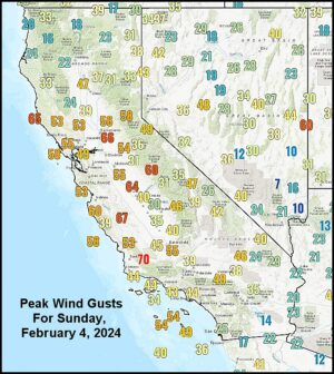
Kansas City, February 5 (World Weather Inc.) – A very intense storm impacted California Sunday and overnight as expected and it will continue to have a big impact on the state into Tuesday. Property damage has occurred in many areas and with another day of storminess expected the impact is likely to rise further.
Big California Storm This Weekend To Rock The State
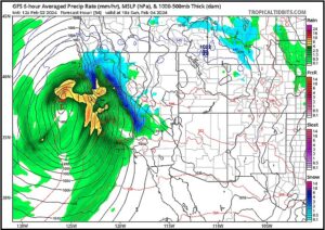
Kansas City, February 2 (World Weather Inc.) – The largest and most adverse storm to impact California in this latest series of storms will impact the state this weekend. Torrential rain, flooding, damaging wind and copious amounts of mountain snow will accompany the system. Travel disruptions are likely along with some damage to personal property and infrastructure.
California, U.S. Southwest To Be Impacted By Winter Storms
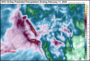
Kansas City, January 31 (World Weather Inc.) – A series of aggressive storm systems will rotate through a deep upper level trough of low pressure expected to push into western North America over the next few days. The storms will promote waves of rain and snow for California, the U.S. southwestern states and northwestern Mexico late this week through much of next week. Coastal flooding and damaging wind will impact many areas with heavy snow slated for portions of the Sierra Nevada. Port and shipping activity will be impacted because of rough seas, damaging wind and flooding rain and some of those conditions will advance inland impacting travel throughout California, including the mountains. Rain and snow will also reach portions of the U.S. southwestern states and northwestern Mexico where flash flooding is expected.
Minimal Rain Forecast for West Texas
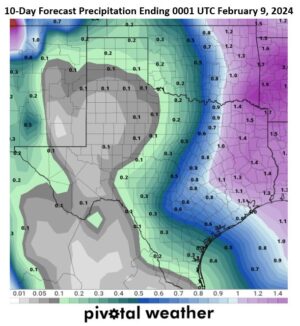
Kansas City, January 30 (World Weather Inc.) – West Texas soil conditions are rated favorably for this time of year, although rainfall has been less than normal during the last 90 days. Most of the moisture deficits are minimal except south of Lubbock where there is some need for moisture. Rainfall in the next 10 days will be minimal, though there is very little reason for much concern since the planting season is still several weeks away. However, the U.S. National Oceanic and Atmospheric Administration has suggested La Nina may develop aggressively during mid-year. If a notable La Nina event develops as quickly as predicted, summer may turn drier and warmer than usual raising the importance of favorable soil moisture during the spring planting season.
U.S. Midwest Will Trend Drier Biased After Recent Precipitation
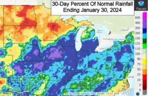
Kansas City, January 30 (World Weather Inc.) – Wetter-than-normal conditions were noted in a large section of the U.S. Midwest in recent weeks. Waves of rain and snow helped improve the moisture profile that will be beneficial for both winter wheat development and spring planting. Several areas in the western Corn and Soybean Belt and Ohio River Valley are still in a drought and would benefit from more precipitation in coming weeks. Precipitation will be limited during the next seven days in part due to a high-pressure ridge over North America. A disturbance tracking near the region could generate some rain in western and southern sections of crop country this weekend and early next week, though not enough will occur to improve soil moisture.
Weekly Citrus Weather for January 30, 2024
Kansas City, January 30 (World Weather Inc.) – Florida’s main citrus areas were drier and warmer than normal during the past week. Irrigation was run as-needed and continued to promote a good environment for tree and fruit development. A disturbance will likely bring rain to the region later this weekend and early next week, which should reduce the need for irrigation. Citrus conditions will remain good. In Brazil, many areas in western Sao Paulo and southwestern Minas Gerais dried down during the past week. The main citrus areas will see a good mix of erratic rain and sunshine in the coming days that will maintain relatively good crop conditions. Concern remains for lower than normal production this season due to citrus greening disease and adverse conditions earlier in the season. Mexico’s citrus areas were mostly dry during the past week and will not receive much rain in the coming week. Drought will spread and intensify.
Weekly Citrus Weather for January 23, 2024
Kansas City, January 23 (World Weather Inc.) – The northwest corner of citrus country in Florida experienced near-freezing temperatures during the past week. No damaging cold weather was noted and overall production potentials were not significantly impacted. Enough rain fell to keep soil moisture at adequate levels for aggressive growth. The region will trend drier than normal during the coming week and the need for irrigation will increase. Brazil’s citrus areas also saw a mix of rain and sunshine during the past week. The main production areas will trend drier than normal during the coming week, but will still receive enough rain to support generally favorable development. In Mexico, Nuevo Leon experienced sub-freezing temperatures during the past week. Citrus damage was likely minimal. The main concern for Mexico remains the ongoing drought. Much of the citrus region will trend drier than normal through early next week.
U.S. Delta Moisture Deficits To Be Diminished By Sunday
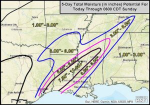
Kansas City, January 23 (World Weather Inc.) – U.S. moisture deficits left over from last summer have been successfully whittled down in recent weeks by periods of rain and snow and cooler temperatures. The one crop region in the nation that still has notable moisture deficits is the Delta and a part of the Tennessee River Basin. Some of the moisture deficits range from 4.00 to nearly 10.00 inches in the most recent 90-day period. Two waves of heavy rain are expected to impact this dry region between now and Sunday producing enough rain to eliminate much of the moisture deficits; however, the precipitation may come a little too fast to avoid at least some flooding.
U.S. High Plains In Need Of Rain; Delta To Receive More Rain
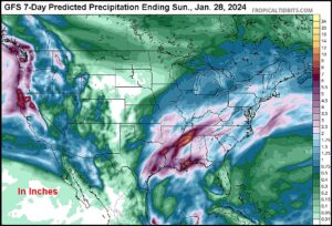
Kansas City, January 19 (World Weather Inc.) – Most of the U.S. high Plains region from West Texas through Colorado and far western Kansas to Montana are dry enough to warrant a closer watch for future precipitation events, despite some areas reporting near or above normal precipitation the past three months. Some erratic precipitation is expected in these areas through the end of January and into early February, but not enough moisture is expected to significantly improve the moisture profile. In the meantime, timely and beneficial moisture has impacted the Delta where precipitation was lacking during the latter months of 2023. Rain is expected to develop in the Delta, eastern Texas, the Tennessee River Basin and a part of the southeastern states this week after the weekend cold abates. Some areas may receive several inches of rain bolstering soil moisture significantly.
World Wheat Weather For Friday, January 19, 2024
Kansas City, January 19 (World Weather Inc.) – Wheat in various areas in North America, Europe and the western Commonwealth of Independent States was subjected to bitter cold weather from the last week of December into the first half of January. In most cases, crop damage was avoided because of widespread snow cover. However, there were holes in the snow cover in the northwestern U.S. Plains, a part of southern Kansas and other areas in the southwestern Plains as well as the Ohio River Valley where some damage may have occurred. Outside of the cold issues, most winter crops are favorably established and poised to start spring favorably.
Weekly Citrus Weather For January 17, 2024
Kansas City, January 17 (World Weather Inc.) – Florida’s citrus areas received rain on a frequent basis during the past week that continued to promote a good environment for citrus development. Rainfall will be more limited during the coming week supporting crop maturation and harvest progress and irrigation will be provided as-needed. The environment will remain generally favorable. Brazil’s citrus region also saw several waves of rain during the past week with more on the way during the coming week. Fruit and tree development conditions will remain favorable. Greening disease remains the greatest concern for Brazil and will likely impact overall production. Mexico’s citrus areas were mostly dry during the past week. Brief periods of light rain will occur through the middle of next week that will be unable to improve the moisture profile. Drought remains the greatest concern and abundant rainfall is needed.
U.S. Sugarcane Braces For Freeze: Florida Citrus To Be Spared
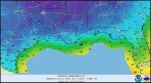
Kansas City, January 12 (World Weather Inc.) – This weekend’s deep arctic air surge into the central United States will eventually reach South Texas and the central Gulf of Mexico Coast States. Frost and freezes will impact most of Texas; including fruit and vegetable production areas in the south. Hard freezes are also expected to the Louisiana coast. Sugarcane in Louisiana is expected to be most significantly impacted by the cold, although some minor impacts on sugarcane and citrus will occur in South Texas and perhaps a few northern citrus production areas in Florida.
NW U.S. Plains Snow Cover To Be Light During Bitter Cold
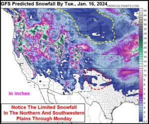
Kansas City, January 10 (World Weather Inc.) – Canada’s Prairies and the northwestern U.S. Plains have been snow free during much of the late autumn and early winter this year. The lack of snow is closely tied to the moderately strong El Nino event that has been underway. The warmth of El Nino is being washed out of the atmosphere by an impressive stratospheric warming event that has relocated the polar vortex in northeastern Europe and it will soon lead to a secondary polar vortex over eastern Canada. That development will bring arctic air to western Canada and the north-central United States without a big improvement in snowfall. As a result winter wheat in Montana, the western Dakotas and a few areas in southwestern Canada may not be adequately protected against damage that could occur by temperatures in the -30s and -20s Fahrenheit.
U.S. Midwest Braces For Damaging Blizzard Friday, Saturday
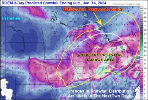
Kansas City, January 10 (World Weather Inc.) – One blizzard has already impacted a part of the Midwest in recent days and another is slated for Friday into Saturday. The new storm will be fueled by warm and moist air over the southeastern United States and very cold and dry air coming southeast from Canada. The intensifying storm will bring trees and powerlines down across the Midwest, produce substantial snow accumulations, close many roads and airports and bring commerce to a standstill. Livestock stress will be high and there will be potential for deaths for both animals and humans during the height of the storm.
U.S. Southeast Excessively Wet From Recent Rain
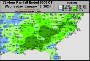
Kansas City, January 10 (World Weather Inc.) – Flood potentials are increasing for the U.S. southeastern states. A storm system that promoted varying amounts of snow and ice across portions of the Plains and Midwest this week also promoted several inches of rain for many areas in the southeastern states during the past three days. The ground is excessively wet, though no severe flooding has occurred thus far. Light precipitation is slated for the region through the middle of next week and flood potentials will decrease slightly. Colder temperatures in the week ahead will limit drying rates and most locations will still have abundant to excessive soil moisture. Precipitation potentials could increase during the second week of the outlook and if significant rain falls again the risk of flooding is likely to increase once more. Drying will be needed prior to spring planting.
Weekly Citrus Weather For Tuesday, January 9, 2024
Kansas City, January 9 (World Weather Inc.) – Florida’s citrus region received timely rain during the past week with more on the way through early next week. Citrus development and minor crop blooming conditions will remain favorable across the region. In Brazil, rainfall varied significantly during the past week in the main citrus locations of Sao Paulo and southwestern Minas Gerais. Citrus conditions remained generally favorable, even in areas that received little or no rain. However, the driest locations would benefit from a boost in precipitation. More widespread rain during the coming week will help bolster or keep soil moisture at favorable levels for aggressive growth. Mexico’s citrus areas were dry or mostly dry during the past week with drier than normal weather persisting through early next week. Harvesting will advance swiftly. The need for timely rain will otherwise increase later this month into February.
U.S. Will Be Impacted By Winter Storms; Arctic Air This Week
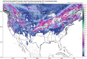
Kansas City, January 8 (World Weather Inc.) – Two winter storms and an Arctic surge will impact central United States this week. The first winter storm is already under way in central U.S. Plains and will advance from there to the Great Lakes region tonight and Tuesday. Heavy snow accumulations are slated from portions of Kansas, eastern Nebraska, and northern Missouri into Iowa, northern Illinois, southern Wisconsin, and portions of Michigan. Travel will likely become hazardous and livestock stress is expected. Another winter storm is expected late Thursday into this weekend with significant snow accumulations possible in portions of the Midwest and neighboring areas. Travel delays and livestock stress are expected with little potential for winter crop damage.
Northern Hemisphere Cold Surge Overview, Forecast
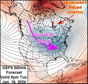
Kansas City, January 8 (World Weather Inc.) – Stratospheric warming advertised at the end of December for January has verified well. Such events are known for displacing the polar vortex, sometimes stretching the vortex out and occasionally splitting the vortex into two vortices. In all cases, cold air aloft is pressured to the surface in the Northern Hemisphere and then spreads to the lower latitudes. The cold surge over Russia and northeastern Europe that has been ongoing for the past week is directly related to the stratospheric warming event and the displacement of the polar vortex. A secondary polar vortex will develop briefly over eastern Canada this weekend into early next week to bring cold weather to North America, but it is not likely to persist like the cold that is projected for northwestern Russia, Scandinavia and some neighboring areas of northeastern Europe.
U.S. Plains Wheat, Livestock Should Survive Coming Cold Wave
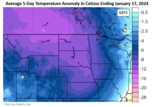
Kansas City, January 5 (World Weather Inc.) – In the next two weeks, an arctic airmass is forecast to move into the central U.S. causing temperatures to gradually drop between 10 and 25 degrees Fahrenheit below normal. Temperatures will eventually become cold enough to threaten any snow- free winter wheat areas. Wheat is largely dormant across the U.S. Plains and Canada’s Prairies, though little to no snowpack exists across a majority of the region, which could leave crops at risk of damage when the airmass arrives. Livestock stress will also be a concern because of the sudden fall in temperatures and bouts of wind and snow. Some travel delay from the potential snow systems is also a concern especially in the central Plains and Midwest while there will likely be a big increase in heating fuel consumption.
Weekly Citrus Weather For January 3, 2024
Kansas City, January 3 (World Weather Inc.) – Florida’s citrus region received light rain during the past week. More significant rain is expected through the middle of next week, which will keep soil moisture sufficient to maintain a favorable environment for citrus fruit development. In Brazil, rainfall varied significantly during the past week. Most areas still had plenty of moisture to support aggressive growth even in areas that received little to no rain. More frequent rainfall through the middle of next week will maintain a good environment for citrus development. Harvesting of Mexico’s citrus will advance swiftly in the coming week due to a lack of significant rain.
Over Zealous ENSO Model Predicts La Nina Again
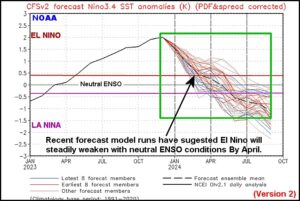
Kansas City, January 3 (World Weather Inc.) – El Nino evolved in the spring of 2023 and steadily intensified until peaking in late November and early December. The event will go down in the history books as a moderately strong ENSO (El Nino Southern Oscillation) event, but relative to others in its class the impact on world agriculture was lighter than expected. Now, forecast models are predicting a rapid demise of the event with neutral ENSO conditions expected by April. But, that is not all…some models go on to predict La Nina later in the year.