
Impressive Snow Falls In U.S. Mid-Atlantic Region Overnight
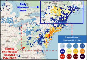
Kansas City, February 23 (World Weather Inc.) – An impressive storm system developed off the U.S. Middle Atlantic Coast Sunday afternoon and night resulting in strong wind speeds and rain changing to snow. Blizzard conditions evolved overnight and some impressive snowfall occurred as the storm center became more intense. Blizzard conditions will continue this morning along the New England coast before the storm moves far enough away to improve weather conditions in the U.S.; though conditions in Nova Scotia and New Brunswick, Canada will deteriorate greatly.
Western United States Snowpack Still Below Normal
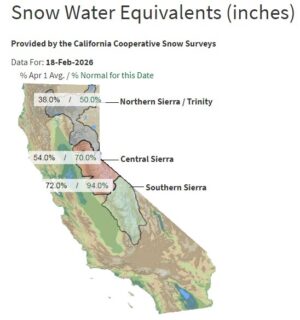
Kansas City, February 19 (World Weather Inc.) – California received significant moisture during the past week that helped bolster mountain snowpack across the Sierra Nevada. Despite this recent influx of precipitation, mountain snowpack across the western United States remains below normal for this time of year. Precipitation over the winter trended below normal in a large section of the western U.S., the central and southern Rocky Mountains in particular. Reservoir levels remain above historical levels in California and there should be enough moisture for the upcoming season. Concerns are otherwise growing for moisture shortages this year in the remaining states where snowpack remains well below normal. California and the Cascade Mountains will see several waves of precipitation during the coming week. Mountain snowpack will further increase, though overall snowpack will likely remain below normal. The Rocky Mountains will also have a few opportunities for precipitation. Snowfall in these areas will marginally bolster snowpack and the need for abundant precipitation will remain high late this month into March.
North America Dryness May Factor Into U.S. Spring Weather
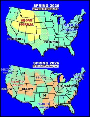
Kansas City, February 18 (World Weather Inc.) – A large part of North America is still dealing with some level of drought and/or dryness which raises some concern for the spring and summer coming up in 2026. This year’s outlook may be influenced by the transition from La Nina to El Nino which has often produced some dryness of its own while the lunar cycle is a little less dry unless one looks into the year 1972.
U.S. Weather To Become Active: Central, NW Plains Stay Dry
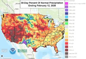
Kansas City, February 13 (World Weather Inc.) – Drought or abnormally dry conditions are an ongoing concern for several crop regions around the United States. Some of the most significant drought was noted from portions of the southern Plains and Delta into the central Midwest as well as in the southeastern states. Several other areas in the Plains and Midwest are also struggling with dryness. While there are still several weeks before planting kicks off in the main agricultural areas, the driest locations will need significant precipitation for better early-season planting and winter grain development. An active weather pattern is slated for North America through the end of next week. Several areas outside of the High Plains region will receive enough precipitation to alleviate “some” of the dryness by this time next week. There will still be a need for precipitation late this month into March to further improve spring crop planting prospects and winter crop development.
Central U.S. Heat To Stress Livestock, Reduce Wheat Hardiness
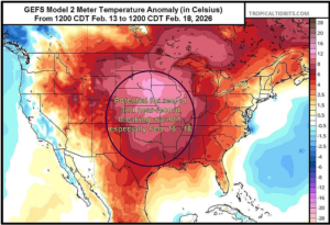
Kansas City, Feb. 12 (World Weather Inc.) – Many daily record highs have been set so far this February in the central and western U.S. and additional records are likely to break next week as the warm weather pattern continues. A broad ridge of high pressure will be situated across the central U.S. in the next eight to ten days, helping to promote the unseasonably warm temperatures. A weather disturbance this weekend will provide a minor break from the warmth in some areas, but next week’s set-up will then favor more record or near-record highs. The warm temperatures will lead to more livestock stress and loss of winter dormancy in the Hard Red Winter Wheat Region, West Texas, and the southwestern Corn Belt. Some wheat greening may begin, especially after this weekend’s rain. Any wheat development will need to be monitored in case of returning cold air
U.S. Hard Red Wheat Areas Will See Drought Expand, Intensify
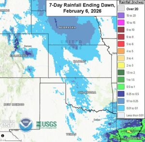
Kansas City, February 6 (World Weather Inc.) – The U.S. central and southern Plains received limited to no precipitation during the past week. Temperatures were seasonable to seasonably warm at times and started to firm the topsoil in most locations. Another week of drier weather is slated for hard red winter wheat country with temperatures climbing above to well above normal. Drying rates will be much higher compared to the past week and drought is expected to expand and intensify. The need for significant rain and milder temperatures will be high later this month and early March to support better long-term development conditions. There is potential for increased precipitation during the February 14 – 20 period, which could offer minor relief from the drying trend for some, though not enough to improve long-term soil conditions.
Florida Citrus At Risk of Freeze Damage Sunday, Monday
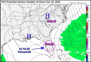
Kansas City, January 30 (World Weather Inc.) – Eastern portions of the United States have been beat up by winter weather in the past week and a final blow to the region is forthcoming this weekend as bitter cold settles in one more time. Unusually cold conditions have already dominated much of the past week, but a final push of arctic air into the eastern states this weekend may push some of the coldest temperatures seen in central Florida in many years. It is not the “perfect storm” for seeing epic cold and crop damage in the region, but temperatures will be low enough to raise the potential for some loss despite the protective steps many producers will take to save the crop. Sugarcane in both Louisiana and Florida will also be nipped.
U.S. Wheat May Have Been Damaged By Weekend Cold
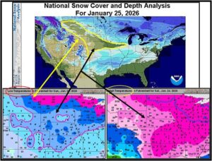
Kansas City, January 26 (World Weather Inc.) – Bitter cold conditions over multiple days without significant snow on the ground may have left U.S. wheat vulnerable to damage from Montana to Nebraska and across the lower Midwest. Damage assessments will not be possible prior to spring and even then it will be difficult to know the impact because of the potential for some crops to recover. This week’s weather will slowly improve in the Plains while the Midwest (now snow covered) remains cold.
U.S. Weekend Storm Shifts Northward; Still Quite A Threat
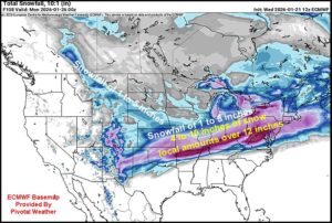
Kansas City, January 21 (World Weather Inc.) – A late week winter storm developing in the southern Plains will move to the east northeast through the Delta and lower Midwest to the Middle Atlantic Coast States. In its wake will be considerable stress to livestock, significant travel delays and possibly some power outages. The storm has potential to produce significant ice and snow accumulations from Texas and Oklahoma to the Carolinas, Virginia and areas north into the Washington, D.C. area. Lighter snow will fall from Kansas and Nebraska to Ohio and bitter cold temperatures will follow the event into the interior southern states. The storm track has creeped northward in the past couple of days.
U.S. Wheat Needs Snow Ahead Of Bitter Cold
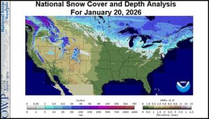
Kansas City, January 20 (World Weather Inc.) – Waves of arctic air continue to march through central and eastern parts of North America. The frequent succession of cold has dried out the atmosphere making it difficult for significant precipitation events to evolve in the northern and central Plains and portions of the Midwest. Two more surges of bitter cold are expected and many areas are snow free. Temperatures will drop near and below zero Fahrenheit later this week and during the weekend raising a little concern over the fate of U.S. hard red and Midwest soft wheat as the coldest air arrives. Most likely the crop will handle the situation relatively well, but a layer of snow would certainly take the worry out of winterkill potentials.
Western U.S. Will Be Drier Than Usual From Nearby Ridge
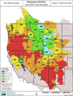
Kansas City, January 16 (World Weather Inc.) – Mountain snowpack is below or well below normal for much of the Cascade Mountains, central Rocky Mountains, and portions of California outside the Sierra Nevada. California received above normal precipitation in recent weeks and the water situation is generally good. Long-term production potentials for the upcoming season are favorable as well due to the good water supply. The Pacific Northwest, Oregon and southern Washington in particular, are otherwise in growing need of precipitation to fill reservoirs and bolster snowpack. The central Rocky Mountains would also welcome increased precipitation. However, much of the western United States will be under the influence of a strong high-pressure ridge through the end of next week. Precipitation will be limited and what precipitation that does occur will be too light to impact the moisture profile long-term. A shift in the upper-air pattern during the last week of January will gradually increase precipitation potentials for the Pacific Northwest and Rocky Mountains region.
Hazardous Travel, Extreme Wind Chills Impact North U.S. Plains
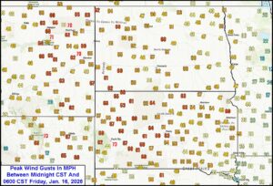
Kansas City, January 16 (World Weather Inc.) – Winter weather has been a bit rare this year across the northern and central U.S. Plains, but today is a different day. Wind gusts of 50-70 mph and morning temperatures in the single digits, teens and 20s Fahrenheit across the northern Plains have combined to produce some very nasty conditions for travelers and livestock. The worst conditions this morning were in the northern Plains, but during the course of the day today the upper Midwest and central Plains will also be impacted. Eventually (this weekend) the wind, blowing snow and falling temperatures will also impact the lower Midwest and portions of the interior southeastern states. Energy demand for supplemental heating fuel will surge higher through the first half of next week and then relax as some moderating temperatures kick in for many areas.
Florida Cools As Expected; Frost, Freezes in Citrus Areas
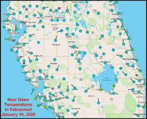
Kansas City, January 16 (World Weather Inc.) – Cold temperatures settled into the southeastern United States overnight bringing some of the lowest temperatures of the season to portions of Florida’s citrus region. Frost and mostly light freeze conditions were common in the key production areas. Damage to unharvested fruit, trees and blossom buds for 2026 should have been minimal due to spray irrigation and other methods of keeping citrus groves warm. Despite the frost and freezes, temperatures were not low enough for a long enough period of time to induce permanent crop damage. Additional bouts of cold will impact Florida early next week and again later this month.
Florida Citrus Farmers Watch Approaching Cold; Frost Likely
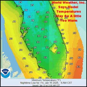
Kansas City, January 15 (World Weather Inc.) – Another unusually cold surge of air is moving through the southeastern United States today and it is expected to bring frost and a few freezes to the Gulf of America coast for at least the fourth time since October on Friday. The cold should not be deep enough to induce serious damage to citrus or sugarcane in the southeastern United States; although it will warrant spray irrigation and some mobile heating units overnight to ensure adequate crop protection especially in northern parts of the citrus belt. Monday may be coolest.
Central U.S. Snowfall Protects Wheat From Weekend Chill
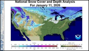
Kansas City, January 11 (World Weather Inc.) – U.S. hard red winter wheat areas and many soft wheat production areas in the Midwest, Delta and southeastern states all benefited from this past week’s precipitation event. The moisture may have been needed most in hard red winter wheat areas where weeks of limited precipitation and very warm temperatures had begun to raise concern for future crop development potential. Sufficient snow fell late last week after some beneficial rain was noted leaving the region in somewhat better condition than it was in prior to the event. The snow also protected wheat from colder temperatures during the weekend.
U.S. Hard Red Winter Wheat To Get Additional Rain Friday
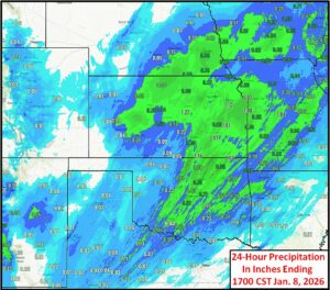
Kansas City, January 8 (World Weather Inc.) – Rain and a few thunderstorms moved across the central and southwestern U.S. Plains today bringing some much needed moisture to parts of hard red winter wheat production areas. The benefits of moisture will be great for future crop development as long as the region cools down enough to squelch any potential for crop development in the next few weeks. The precipitation reported today was most beneficial in central Kansas, south-central Nebraska and central Oklahoma leaving the high Plains region without much moisture. A follow up disturbance late tonight and Friday should being some additional moisture from southeastern Colorado and the far northwestern Texas and Oklahoma Panhandles to central Kansas further increasing soil moisture for some areas.
U.S. Southeast Drought To Continue Despite Some Rain
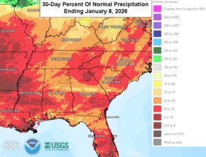
Kansas City, January 8 (World Weather Inc.) – The U.S. southeastern states experienced drier than usual conditions the past few months. The lack of precipitation helped drought develop, intensify and spread across the region. While the region is not a major producer of winter crops, the crops that are grown will need greater precipitation in coming weeks to support better development potentials this spring. Precipitation will also be needed for better planting prospects once seasonal warming occurs this spring. A close monitoring of the situation is warranted since continued dryness may delay planting and impact planted acreage for the upcoming season; though it is much too soon to speculate over that. The southeastern states will have a few opportunities for rain during the coming week. The greatest moisture will occur outside the main production areas while the bulk of crop country only receives light rain. Drought will persist for most locations and the need for significant precipitation will remain high.
Central, East U.S. And East Canada To See Stormy Weather
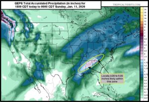
Kansas City, January 7 (World Weather Inc.) – A trough of low pressure is moving into the western U.S. today and will then move across the central part of the nation later this week. This trough will be made up of two weather disturbances, with the lead disturbance causing rain in the Hard Red Winter Wheat Region and Corn Belt late today through Thursday. The second disturbance will produce snow in a similar area Friday through Saturday while also producing significant rainfall from the Delta into Virginia. The precipitation will be beneficial in the Hard Red Winter Wheat Region; however, snow could cause some travel delays and livestock stress, especially near the Great Lakes, and rainfall from the Delta into Virginia could cause localized flooding. The Great Lakes region through Quebec, Canada may be more notably impacted by snow; though the west-central high Plains should be impacted as well.
U.S. Hard Red Wheat Country Too Warm, Too Dry
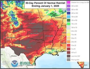
Kansas City, January 2 (World Weather Inc.) – The U.S. central and southern Plains experienced drier or much drier than usual conditions in December. The lack of precipitation combined with periods of much warmer than usual conditions kept soil moisture below favorable levels for ideal long-term hard red winter wheat conditions. Many areas in the southern Plains have been warm enough for a long enough period of time to promote new growth, though the lack of significant precipitation or soil moisture has prevented aggressive development. At least another week of drier and warmer than normal weather is slated for these areas. There is potential for some precipitation later this month that may marginally raise soil moisture in a few locations. However, the need for significant precipitation will remain high heading into the latter part of the month especially in the southwest.
California Flood Potentials Will Increase In Coming Days
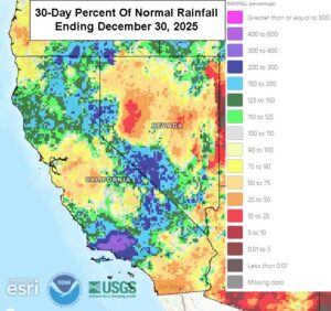
Kansas City, January 1 (World Weather Inc.) – Precipitation varied across California in December. Much of the north and the Sierra Nevada have been wetter than usual while the central valleys have trended drier than usual. Mountain snowpack is generally below normal for this time of year; though that situation may change greatly in the coming week. The state will now face waves of precipitation through the middle of next week. Rain will lash California on a frequent basis to potentially promote significant flooding, especially in northern parts of the state and possibly in the Los Angeles Basin. Mountain snowpack will increase significantly across the Sierra Nevada as well. The moisture will be ideal for water supply and soil moisture, although in the near term there is likely to be some damage to infrastructure and some personal property and crop land.
Some SE U.S. Sugarcane, Citrus To See Frost, Brief Freezes
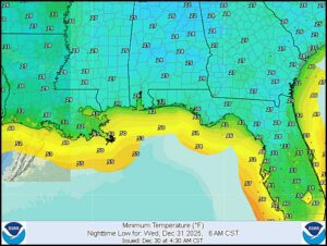
Kansas City, December 30 (World Weather Inc.) – Frost and freeze conditions are likely to impact sugarcane areas of Louisiana and minor citrus production areas of northern Florida Wednesday morning for the third time since October. The impact of cold conditions has been relatively low in past events and the same is expected Wednesday. Temperatures will not be cold enough to induce any permanent damage in sugarcane areas, but some citrus groves in northern Florida will need the assistance of irrigation systems to provide some protection to unharvested fruit and flower buds for the coming season. Other fruit trees in the southeastern United States have been impacted by widely swinging temperatures in recent weeks and this trend will continue into late winter.
Second Flood Event Hits Southern California During Christmas
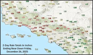
Kansas City, December 26 (World Weather Inc.) – Severe flooding resulted in the Los Angeles Basin in southern California during the Christmas holiday. The event was a near duplicate of the flood event that impacted the same region November 15 – 18 causing extensive damage and impacting travel. The excessive precipitation event resulted from a combination of factors including unusually warm ocean surface temperatures between Hawaii and California and a series of weather disturbances moving through the region picking up greater moisture from the ocean as they moved inland. The Sierra Nevada and other areas in northern California were also impacted. World Weather, Inc. suggests there is some potential for another wave of significant rain in the first days of February.
Heat To Expand Central U.S. Dryness; Much Colder Sunday
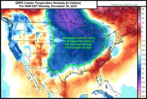
Kansas City, Dec. 24 (World Weather Inc.) – A significant ridge of high pressure has built into the central U.S. as expected and is causing temperatures to become incredibly warm for this time of year across much of the country. Many record highs will be broken today through Saturday before a period of cooling evolves. The heat will induce some livestock stress from West Texas into Oklahoma. The ridge will also further deplete soil moisture worsening moisture shortages already present in a part of the Great Plains southwestern Midwest and Delta. Snow cover has been recently diminishing in the Northern Plains and with additional melting may leave some areas exposed to subzero Fahrenheit temperatures when much colder air arrives Sunday.
Impressive Rain, Flooding In Northern California To Continue
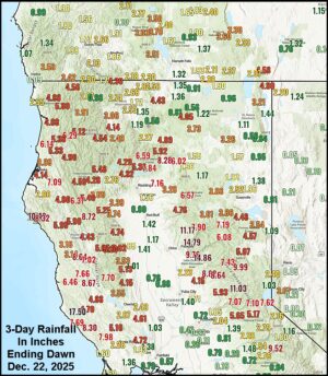
Kansas City, December 22 (World Weather Inc.) – Rain developed in northern California and southern Oregon during the weekend and some of the rain totals were rather impressive. Flooding resulted in a number of areas and more storminess is expected this workweek that may contribute greatly to the rain already reported. Flooding may continue and could worsen in some communities. The rain will spread to the south into southern California as the week wears on. The warm ocean water between Hawaii and California contributed to the flooding rain as suggested would be the case earlier this month.
South U.S. Plains Heat To Stress Livestock, Remove Moisture
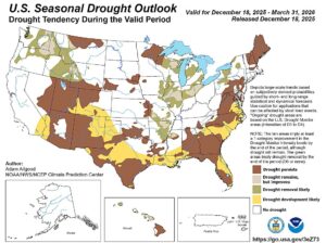
Kansas City, December 19 (World Weather Inc.) – As a follow up to Thursday’s strong ridge high of high pressure article written by World Weather, Inc. it is very important to note the impact of the heat on agriculture. Indeed warm and dry conditions will be ideal for holiday travel and outdoor activities, but with temperatures frequently rising into the 70s and some 80s Fahrenheit during the coming week to ten days there is liable to be some livestock stress and a further loss in soil moisture that may excite some of the wheat producers and commodity trade as winter crops lose hardiness and become more drought stressed.
Christmas High Pressure Ridge To Dramatically Heat Up U.S.
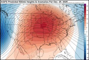
Kansas City, December 18 (World Weather Inc.) – Dramatic changes in North America weather during the coming week will remove threats of bitter cold from the central and eastern United States and replace them with the potential for unseasonable warmth. Temperatures will be far enough above normal in the central and southern parts of the nation to raise the potential for outdoor grilling of Christmas dinners instead of oven baked goods that usually are more traditional for the holiday.
Impressive Windstorm Impacts NW, North-Central U.S.
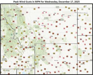
Kansas City, December 18 (World Weather Inc.) – An impressive windstorm impacted portions of North America Wednesday and early Thursday as a deep low pressure center developed very quickly over southern Alberta, Canada and moved to northern Minnesota overnight. The storm produced damaging wind from the U.S. Pacific Northwest through the northern and some central Rocky Mountain locations into the northwestern and west-central Great Plains. Power Outages and damage to both personal property and infrastructure resulted. The same storm produced blizzard conditions across the southern Canada Prairies into North Dakota creating hazardous travel conditions and stress for livestock.
North America Weather Patterns Changing
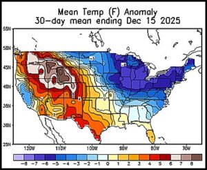
Kansas City, December 17 (World Weather Inc.) – A notable early season stratospheric warming event that occurred in mid-November brought widespread snow and much colder temperatures to Canada, the north-central and eastern portions of the United States the past few weeks. The event displaced the polar vortex bringing much colder weather to portions of North America. The impact of these atmospheric changes has been substantial, but the effects are waning and the polar vortex is expected to relocate over the North Pole in the last days of December making the potential relatively good for a relaxing of the anomalous weather pattern allowing La Nina to have a little more influence until it too weakens and diminishes in January.
Major Swing In Temperatures Coming For Central, East U.S.
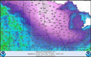
Kansas City, Dec. 11 (World Weather Inc.) – A significant arctic air mass is about to move southeast from western Canada and impact the Northern Plains and Corn Belt regions of the U.S. Friday through Sunday. Temperatures will drop well below zero across most of these areas; though, crops will be mostly protected with favorable snow cover. The cold air along with additional snow will lead to livestock stress and some more travel delays. The arctic air will be quick to leave in the early part of next week though as a ridge of high pressure expands and shifts from the west. This will cause a dramatic rise in temperatures Monday through Wednesday with many areas east of the Rocky Mountains going from well below to well above average temperatures in the span of a few days.
Excessive Rainfall in US Pacific Northwest Induces Flooding
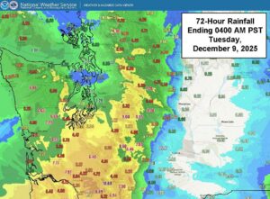
Recent heavy rainfall in the U.S. Pacific Northwest has created a significant flood and landslide risk across the Cascades. Between 3.00 and 10.00 inches of rain has occurred in western Washington and northwestern Oregon since Saturday, with an additional 4.00 to 12.00 inches expected in the next 7 days. Shipping delays and impacts to commerce in the Puget Sound are expected until flooding subsides. Minimal rainfall has occurred on the eastern slopes of the Cascades; however, runoff from this excessive rain is expected to cause moderate flooding along various rivers in central Washington, including the Yakima River Basin. Crops in low lying areas near the flood plane of the Yakima River may see damage, though overall crop impacts caused by flooding are expected to be minimal.
Weekly Citrus Weather For Tuesday, December 9, 2025
Kansas City, December 9 (World Weather Inc.) – Florida’s citrus areas saw periods of rain during the past week. Minor harvest delays were possible, though most producers had opportunities to harvest between rain events. The region will receive limited rainfall during the coming week and the harvest should advance swiftly. Many areas in Brazil’s citrus areas dried down significantly earlier this month before timely rain occurred in recent days. The region will see a period of wet weather through early next week that will bolster soil moisture and maintain good citrus conditions. Mexico’s citrus areas will also see periods of erratic rain during the coming week. The harvest may be disrupted in the wettest locations.
No U.S. Crop Damage Suspected From This Week’s Cold
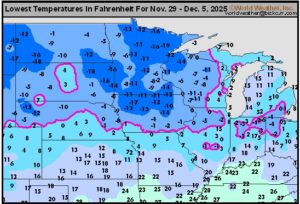
Kansas City, December 5 (World Weather Inc.) – An early-bout of winter air impacted the main agricultural areas in the United States in recent days. Temperatures plummeted below zero degrees Fahrenheit in much of the northern Plains into areas as far south as Iowa, Wisconsin, northern Nebraska, and portions of the central Midwest. These areas were generally blanketed by snow ahead of the coldest air and no damage occurred to winter crops. Late-season fieldwork likely came to a standstill due to the snow. Another blast of arctic air will impact portions of the northern Plains and Midwest through early next week with another round of cold air possible toward the end of next week. These areas should have enough snow to protect any winter crops that are in the ground.
N. America Warming Next Week; More Cold Mid To Late Month
Kansas City, December 5 (World Weather Inc.) – Mid-November stratospheric warming induced the recent bout of bitter cold in North America. Another short term bout of bitter cold is expected in the north-central United States and Canada’s eastern Prairies Sunday into Monday followed by a short term bout of warming. However, a secondary polar vortex is expected to evolve near Hudson Bay in northeastern Canada late next week and once that feature is in place the potential is high for returning bitter cold into the central United States during the middle part of the month before shifting into the eastern states and eastern Canada a few days later. There is some indication that the cold will be around into the week of Christmas inducing more snow and a strong energy demand for the Midwest and eastern parts of North America.
Weekly Citrus Weather For Tuesday, December 2, 2025
Kansas City, December 2 (World Weather Inc.) – Florida’s citrus areas received erratic rainfall at times during the past week. Spotty rain will occur at times during the coming week as well, though not enough to significantly impact harvesting and general farming activity. Brazil’s citrus areas were mostly dry during the past week. Rain potentials will increase during the coming week and should maintain good development conditions for the short-term. However, much more rain will be needed for ideal long-term production potentials. Veracruz and immediate neighboring areas in Mexico received significant rainfall during the past week. Harvest delays were a concern in the wettest locations. Mexico’s citrus areas will see periods of erratic rainfall during the coming week that may again impact harvest conditions.
Southeast U.S. To Get More Drought Relief This Week
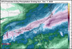
Kansas City, December 2 (World Weather Inc.) – Drought has intensified in the southeastern United States during the autumn season this year. Portions of peanut, cotton, corn and soybean country in Georgia, southern Alabama and northern Florida have been in a drought of varying degrees of significance in recent weeks. Severe to exceptional drought was declared by NOAA’s Drought Monitor last week. Rain fell Monday into this morning across a part of the dry region offering some temporary relief; however, much more rain is needed to end drought conditions. A second wave of rain is predicted for the region Friday into the weekend that should have a greater impact on easing dryness.
North America Cold Will Prevail In December
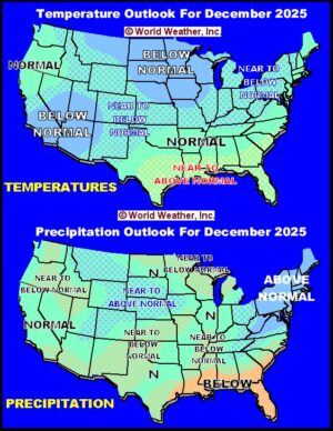
Kansas City, December 1 (World Weather Inc.) – Colder-than-usual weather is slated for much of North America during December. The weekend cool off was just the beginning of a succession of cold surges that is predicted for the month. Precipitation is expected to be above normal in western Canada, the northwestern U.S. Plains, portions of the Rocky Mountain region and from the eastern Midwest through the northeastern states. Below normal precipitation is expected in the southwestern Great Plains and some of the Gulf of America coastal area along with the southernmost Atlantic Ocean coast. The winter outlook has not changed much except for less precipitation in the southeastern states.
Weekly Citrus Weather For Tuesday, November 25, 2025
Kansas City, November 25 (World Weather Inc.) – Florida’s citrus areas were mostly dry and a little warmer than usual during the past week. The region will have a few opportunities for spotty rain during the coming week, though irrigation will remain the primary source for moisture. Brazil’s citrus areas saw a mix of spotty rain and sunshine during the past week. Most locations have enough moisture to support good development in the short-term, though Sao Paulo and southwestern Minas Gerais need more significant rain for ideal long-term production potentials. Most locations will trend a little drier than usual through early next week. Mexico’s citrus areas will have opportunities for rain during the coming week as well. Veracruz and Tamaulipas will trend wetter than usual with concerns for delayed harvesting and fruit swelling.
North-Central U.S. Storms To Slow Travel, Stress Livestock
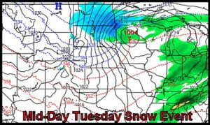
Kansas City, November 24 (World Weather Inc.) – Bitter cold air slowly sagging southward from the Arctic will help stimulate three waves of snow and a notable cooling trend across the northern Plains, Canada’s Prairies and the upper U.S. Midwest tonight through the coming weekend. The storms will slow travel for the Thanksgiving Holiday and will also stress livestock as they deal winter at its worst this weekend.
U.S. Rain To Slow Harvest, Benefit Wheat; Cotton Quality Risk
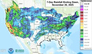
Kansas City, November 20 (World Weather Inc.) – U.S. rainfall during the past week was just enough to benefit some of the soft wheat produced in the lower Midwest. The moisture briefly disrupted late season summer crop harvesting as well, but the delays were not long lasting. California crops experienced the greatest and most prolonged rainfall raising some concern over cotton quality and some of that moisture is expected to stream into the southern Plains periodically into next week. Additional moisture is also anticipated for the lower Midwest, Delta and Tennessee River Basin in this coming week resulting in additional field working delays while improving long term soil moisture. Winter wheat establishment prior to dormancy will have some chance to improve because of the moisture, although time is running out before cold air overtakes some of the production areas. Cotton quality concerns will shift from California and Arizona to parts of West Texas during this period.
Weekly Citrus Weather For Tuesday, November 18, 2025
Kansas City, November 18 (World Weather Inc.) – Florida experienced its first bout of cold temperatures last week. Low temperatures dipped to the 30s Fahrenheit November 11 with light frost and freezes noted in the northwest corner of citrus country. Damage to citrus was suspected of being minimal. Overall, production potentials remain favorable. In Brazil, the main citrus areas saw a mix of erratic rain and sunshine during the past week. Periods of erratic rain will continue during the coming week and maintain relatively good citrus conditions. Spotty rain will otherwise occur in portions of Mexico during the coming week. No major harvest delays are expected.
Weekly Citrus Weather For Tuesday, November 11, 2025
Kansas City, November 11 (World Weather Inc.) – A cold front helped bring temperatures into the 30s Fahrenheit this morning in Florida. No major freezes were noted, though pockets of frost were possible. Citrus impacts were likely minimal. Nighttime lows will again drop to the 30s for portions of Florida Wednesday morning before warmer air returns. No major frost or freezes are expected. In Brazil, seasonal rain was noted during the past week with more on the way in the coming week. Citrus development conditions will be favorable. Mexico’s citrus areas will see some spotty rain during the coming week. Harvesting and general farming activity will advance around the rain.
U.S. Weekend Cold Surge To Stress Livestock; Freezes To Delta
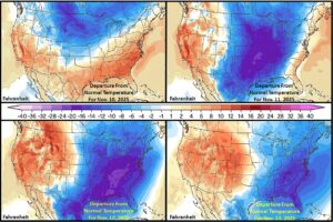
Kansas City, November 5 (World Weather Inc.) – An impressive cold surge will move into the central and eastern parts of North America this weekend into early next week. The cold will be the most potent of the season pushing frost and freeze conditions southward into the Delta and Tennessee River Basin. The cold will come with considerable wind and some rain and snow. The sudden change in temperature will be stressful for most living things; including livestock in the Plains, Midwest and Mid-South regions. The duration of coldest conditions will be short, although a reinforcing shot of cool conditions will impact the northern Midwest for a while next week.
Weekly Citrus Weather for Tuesday, November 4, 2025
Kansas City, November 5 (World Weather Inc.) – Florida’s citrus areas were mostly dry during the past week. The main citrus areas will only have a few opportunities for rain during the coming week and the region will rely on irrigation. Citrus conditions will remain favorable. Seasonal rain was noted in Brazil’s citrus areas during the past week with more on the way in the coming week. Soil moisture will increase and the environment will improve or remain favorable for the citrus. In Mexico, Veracruz and neighboring locations will have several opportunities for rain during the coming week. Citrus prospects will remain relatively favorable across the country, even in areas that receive little or no rain.
U.S. Winter 2025-26: Stormy, Cold East
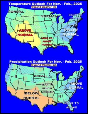
Kansas City, October 31 (World Weather Inc.) – November weather is expected to return below-normal precipitation to most of the Midwest, Great Plains and southwestern states. Temperatures should be cooler than usual in the eastern United States and warm in the northwest half of the nation. Winter 2025-26 is expected to perpetuate some of these anomalies with a part of the Rocky Mountain region warmer than usual while the eastern United States is cooler and wetter biased. The winter may have multiple nor’easter type storm systems that evolve along the middle and lower Atlantic Coast and move northward into New England. The stormy weather in the east will lead to greater snow depths in some areas and that may help reinforce a cooler-biased winter that may raise supplement heating fuel demand and induce some frequent travel issues.
Weekly Citrus Weather For Tuesday, October 28, 2025
Kansas City, October 28 (World Weather Inc.) – Florida’s citrus region will trend drier than usual during the coming week in part due to Hurricane Melissa. The disturbance will not make a direct impact on citrus country and most areas will still have enough moisture to support new growth. In Brazil, seasonal rains will expand across the main citrus region during the coming weeks. The environment will improve or remain favorable as citrus continues to bloom and develop. Mexico’s citrus areas will also see a mix of rain and sunshine during the coming week that will maintain relatively good growth.
Hurricane Melissa Begins To Pound Jamaica; Cuba Next
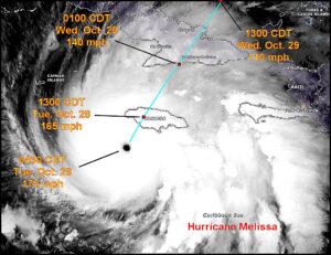
Kansas City, October 28 (World Weather Inc.) – Hurricane Melissa intensified to 175 mph late Monday and has remained extremely intense overnight. The storm continues to move much too slowly to avoid the worst conditions over Jamaica and the island is bracing for catastrophic damage from this super intense storm. At one point Monday, Hurricane Hunters were unable to penetrate the storm because of its extreme turbulence. The storm was moving north northeasterly at only 5 mph will reach the southern coast of Jamaica around mid- to late morning today producing wind speeds at a devastating sustained rate of 165 mph with gusts approaching 190 mph. Such wind speeds and accompanying intense rain and flooding will cause catastrophic damage and possible loss of life. Eastern Cuba will also be impacted tonight and Wednesday with a sustained wind speed of 140 mph at the time of landfall west of Santiago de Cuba.
U.S. Soybean, Corn Harvest Resumes After Brief Weather Delay
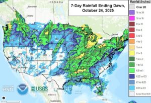
Kansas City, October 24 (World Weather Inc.) – Ran fell earlier this week in the central and eastern U.S. Midwest, Delta and Tennessee River Basin inducing some short term field working delay. Both the harvest of summer crops and the planting of wheat were disrupted; though, the moisture was needed for winter wheat emergence and establishment in some areas. Rain this weekend and early next week is expected to move from the southern Great Plains through the Delta and a few southernmost Midwest locations to the southeastern states. Fieldwork will be disrupted in these areas once again, although a few days of drying occurred between rain events to allow some fieldwork to take place. In the meantime, the high Plains, Great Lakes region, southwestern desert region and a part of the Pacific Northwest will be dry favoring fieldwork through much of next week.
Weekly Citrus Weather for Tuesday, October 21, 2025
Kansas City, October 21 (World Weather Inc.) – Florida’s citrus areas either received enough rain or had enough moisture to support good citrus conditions during the past week. The region will only have a few opportunities for spotty rain in the coming week, though production potentials will remain favorable. Mexico’s citrus areas will also remain favorable in the coming days despite the lack of rain in the northeast. Brazil’s citrus areas saw a good mix of rain and sunshine during the past week. Sao Paulo and southwestern Minas Gerais will trend drier than usual during the coming week. The need for significant rain will increase later this month into early November for most locations.
Tropical Storm Melissa Forms in Caribbean Sea
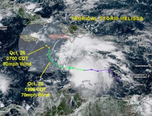
Kansas City, October 21 (World Weather Inc.) – Tropical Storm Melissa has formed in the central Caribbean Sea and will be a slow moving storm for a few days while intensifying. It may have influence on Jamaica and Hispaniola where showers and strong thunderstorms and gusty surface wind is likely. The longer range outlook for the system is still up for debate, but a cold airmass moving through the United States next week may pick up the storm and eject it into the Atlantic Ocean after moving across the Greater Antilles.
U.S. Midwest Will See Some Relief From Drought
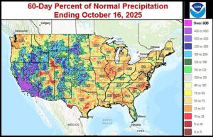
Kansas City, October 17 (World Weather Inc.) – Several locations in the eastern and central Midwest dried down during the past month as drier- and warmer-than-normal weather was common. The environment was favorable for corn and soybean maturation and harvesting. The harvest is estimated to be nearly halfway complete and there is still a need for drier weather in coming weeks. However, the need for precipitation is also increasing to reverse the drought and support a better outlook for winter wheat and early-season planting prospects next spring. Several areas in the eastern and central Midwest will receive significant rain in the coming days that will briefly slow the harvest while improving the moisture profile. In the meantime, the U.S. Plains will trend dry or receive limited precipitation through the end of next week. Summer crop harvesting and hard red winter wheat planting will advance swiftly. Timely rain will be needed late this month and early November to improve or maintain relatively good wheat establishment.
U.S. Pacific Northwest Drought Intensifying; Relief On The Way
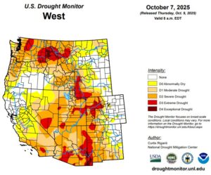
Kansas City, October 15 (World Weather Inc.) – Washington, much of Idaho, and portions of Oregon are enduring various stages of drought or abnormally dry conditions. Much of Washington and Oregon were drier than usual during the past month that, combined with periods of warmer than usual weather, promoted aggressive drying. A large section of Idaho received near to above normal precipitation during the past month, though precipitation was too light to fix long term dryness. Water reservoir levels are extremely low in Washington making this year’s wet season extremely important for irrigation in 2026. Precipitation will initially be limited for much of the Pacific Northwest outside areas near and west of the Cascade Mountains through the middle of next week. There is potential for more significant precipitation later this month and in early November that may help improve the moisture profile.
Weekly Citrus Weather For Tuesday, October 14, 2025
Kansas City, October 14 (World Weather Inc.) – Florida’s main citrus areas received varying amounts of rain during the past week. Citrus conditions remained favorable, even in areas that only received light rain. Alternating periods of rain and sunshine will maintain a good environment for the citrus in the coming week. In Mexico, flooding was noted in Veracruz, Puebla, and neighboring locations during the past week. Fruit swelling or tree damage was possible, though the extent of the damage was not yet known. Waves of rain will prevail in east-central and western Mexico during the coming week. Brazil’s citrus areas saw a good mix of rain and sunshine during the past week with more on the way in the coming week. Citrus blooming conditions will slowly improve.
U.S. Drought Will Prevail For Main Agricultural Areas
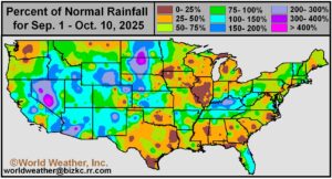
Kansas City, October 10 (World Weather Inc.) – Drought or abnormally dry conditions were noted in a large section of the U.S. Midwest, southeastern states, Delta and pockets in the Great Plains in recent weeks, despite some recent rain. The lack of rain was beneficial for maturation an early-season summer crop harvesting. Precipitation will remain limited for at least another week in a large section of crop country and harvest conditions will remain relatively favorable. Hard red winter wheat planting in the central and southern Plains will also advance well with few disruptions through the end of next week. The need for timely rain will increase later this month to support ideal establishment.
U.S. Midwest October Weather To Remain Drier Than Usual
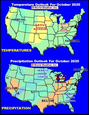
Kansas City, October 1 (World Weather Inc.) – Seasonal changes in weather will attempt to bring some cooler temperatures to key U.S. crop areas and in the process there should be a little more rainfall. However, the odds are relatively high that the lower and eastern Midwest, Delta and southeastern Great Plains will continue drier than usual during the month. A similar below average precipitation bias may occur in portions of the far western states with the exception of a tropical cyclone that may move through a part of the region during the first week of the month. Wet biased conditions will be confined to the southeastern corner of the U.S. and in parts of the northern Plains and upper Midwest.
Weekly Citrus Weather For Tuesday, September 30, 2025
Kansas City, September 30 (World Weather Inc.) – Florida’s citrus areas saw a good mix of rain and sunshine during the past week. Waves of rain are slated for the region during the coming week with flood threats increasing along the Atlantic coast. While damage will likely be minimal, farming activity may advance slowly. Other locations will have ample moisture to maintain aggressive growth. Mexico’s citrus areas saw a good mix of rain and sunshine during the past week. Western and east-central Mexico will receive additional rain during the coming week while northeastern Mexico starts to dry down. Most areas will still have ample moisture for new growth. Brazil’s citrus areas will see relatively good conditions for harvesting and general farming activity.
October Will Arrive Without La Nina; Is It Still Expected?
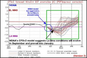
Kansas City, September 30 (World Weather Inc.) – Similar to last year, NOAA’s CFSv2 ENSO forecast model has been predicting La Nina and yet it still does not exist. October will begin with neutral ENSO conditions which is different from what was predicted in recent weeks. NOAA’s forecast model suggested La Nina would evolve in September and be well under way in October, but recent data suggests a much less aggressive evolution toward the phenomenon. World Weather, Inc. suggests caution is needed when forecasters and analysts start blaming the lack of rain in center west and center south Brazil on La Nina development since it has not evolved. Weather around the world looks and feels much like that of last year which was another year in which La Nina was predicted and yet it did not evolve until briefly in the December through February period.
Worrisome Stage Set For Excessive Rain In Carolinas
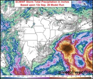
Kansas City, September 26 (World Weather Inc.) – A worrisome setup in the atmosphere may lead to copious rainfall in the Carolinas and neighboring southeastern Virginia next week and the situation will need to be closely monitored during the weekend. Hurricane Humberto, a mid-latitude trough of low pressure over the eastern United States, a strong surface high pressure system over eastern Canada and a developing tropical cyclone near the eastern tip of Cuba will combine forces during the early to middle part of next week to possibly bring a tropical cyclone into the Carolinas or at least induce substantial rain and flooding to a part of the region. Nothing about this situation is ‘set in stone’ and any one of the influential weather features could change the outcome for the Carolinas. For now, though, residents in the Carolinas should be planning ahead for the possible impact of a tropical cyclone and, if nothing else, making plans to deal with flood water.
Lower U.S. Midwest, North Delta And Tennessee Dryness Eased
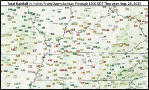
Kansas City, September 26 (World Weather Inc.) – Rain earlier this week brought some much needed relief to drought and dryness from the northern Delta into southern Missouri, Kentucky, Tennessee and southern portions of both Indiana and Ohio. The rain came too late to help late season crop production, but it did settle the dust and improved topsoil moisture for wheat planting this autumn. More rain is needed to get river and stream flows to increase a little more, but with the harvest looming it would be best for follow up rain to fall later in the autumn. Quick drying in the coming week will get farmers back into their fields relatively fast.
Tropical Cyclone May Bring Flooding to Carolinas, Virginia
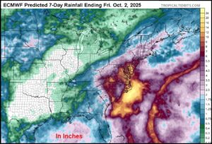
Kansas City, September 25 (World Weather Inc.) – Computer weather forecast model changes overnight regarding a tropical disturbance near the northern Leeward Islands has raised the potential for flooding rain to impact the Carolinas and Virginia next week. The disturbance is expected to evolve into a tropical cyclone this weekend and it may be pushed inland by the combined influences of Tropical Storm Humberto and a mid-latitude trough of low pressure over the eastern Midwest. The forecast is bound to change as adjustments to the position and intensity of each weather feature is made in future model runs.
Tropical Storm Humberto Not Likely To Impact U.S.
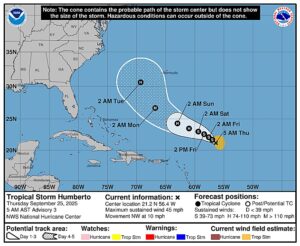
Kansas City, September 25 (World Weather Inc.) – Tropical Storm Humberto formed Wednesday afternoon over open water in the tropical Atlantic Ocean and it will intensify to a hurricane this weekend while moving west northwesterly and eventually northwesterly over open water in the western Atlantic Ocean. The storm will eventually (early to mid-week next week) pass to the west of Bermuda, before turning to the northeast and moving away from North America.
Central U.S. Drying To Accelerate Wheat Planting
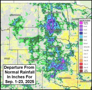
Kansas City, September 24 (World Weather Inc.) – Frequent rain so far this month in the central United States has bolstered soil moisture and slowed early season planting in wheat production areas. However, the moisture has set the stage for aggressive seeding, germination and emergence over the next couple of weeks as drier weather evolves over the region. Aggressive planting early this year is prescribed to get crops in the ground and established well prior to the possible influence of La Nina’s drier bias that may evolve later this season. The moisture is also supporting improved livestock grazing conditions.
Weekly Citrus Weather for September 23, 2025
Kansas City, September 23 (World Weather Inc.) – The citrus areas in Florida received rain on a frequent basis during the past week, keeping soil moisture at favorable levels for aggressive growth. Additional rain during the coming week will continue to support a good environment for the citrus. Mexico’s citrus areas also received monsoonal rain on a frequent basis during the past week with more on the way in the coming days. Citrus development conditions will remain favorable while harvesting may advance slowly during the wettest periods. Brazil’s citrus region will have a few opportunities for spotty rain during the coming week, though no major delays are expected.
U.S. Midwest, Delta Rain This Week To Ease Dryness Not End It
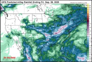
Kansas City, September 22 (World Weather Inc.) – Drought in the lower eastern Midwest, Delta and Tennessee River Basin has become quite a festering event in recent weeks raising worry about river levels and winter wheat planting moisture. Showers during the weekend brought a little teasing amount of moisture to parts of the dry region. Additional showers and thunderstorms are expected through the middle of this week promising to settle the dust and reduce some of the fear about long term dryness; however, another period of dry and warm weather will follow that may limit the relief for a while longer.
Tropical Depression Seven Forms In Atlantic Ocean
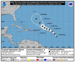
Kansas City, September 17 (World Weather Inc.) – A new tropical depression (seven) formed in the central tropical Atlantic Ocean overnight and was expected to become a hurricane eventually. The storm should be named Gabrielle and will move toward Bermuda. The system should turn off to the east northeast next week posing no threat to the United States or Canada.
Weekly Citrus Weather For Tuesday, September 16, 2025
Kansas City, September 16 (World Weather Inc.) – Florida’s citrus region received rain on a frequent basis during the past week. With waves of rain continuing for the next several days, the environment will remain favorable for aggressive citrus growth. Mexico’s citrus areas received varying amounts of rain during the past week. Citrus conditions remain relatively good despite the potential for localized flooding in Veracruz and San Luis Potosi. The main citrus areas will again see a mix of monsoonal rain and sunshine during the coming week. Brazil’s citrus region could also receive rain early next week that could impact harvesting and general farming activity.
Lower U.S. Midwest, Delta Drought Not To Break For A While
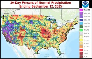
Kansas City, September 12 (World Weather Inc.) – Dryness in the lower Midwest, Delta and Tennessee River Basin will prevail for another ten days to two weeks. There are two ways the drought will break; either from a tropical cyclone moving northward from the Gulf of America or from a sudden southward shift in the jet stream bringing a stronger temperature contrast across the Midwest with cool air to the north and warm air to the south. Neither of these changes in weather is likely through the next ten days. The tropics may provide the greatest hope for relief since in the past when chronic dry conditions prevailed; tropical cyclones usually broke the anomaly.
Weekly Citrus Weather For Tuesday, September 9, 2025
Kansas City, September 9 (World Weather Inc.) – Waves of rain were noted in Florida during the past week and, with more on the way in this coming week, the environment will remain favorable for aggressive fruit and tree growth. Mexico’s main citrus areas also received monsoonal rainfall on a frequent basis during the past week. Monsoonal precipitation will prevail for western, east-central, and northeastern Mexico on a frequent basis during the coming week. Citrus conditions will either improve or remain favorable. Brazil’s citrus areas will either be dry or not receive enough rain to counter evaporation during the coming week. Harvesting and general fieldwork will advance swiftly.
North America Cold Impact May Be Greater Than Expected
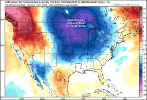
Kansas City, September 3 (World Weather Inc.) – Evidence continues to build over the potential for this week’s frost and freezes in the north-central United States and neighboring areas of Canada to be greater than advertised. There is a growing potential for more broad-based frost to occur from Saskatchewan, eastern Alberta and Manitoba, Canada into the northern U.S. Plains and upper Midwest. Predicted temperatures may not be cold enough and the impact on crops may end up being greater than expected.
Weekly Citrus Weather For Tuesday, September 2, 2025
Kansas City, September 2 (World Weather Inc.) – Florida’s citrus areas received widespread rain on a frequent basis during the past week. Rain and thunderstorms will continue on a frequent basis during the coming week and will maintain a good environment for citrus tree and fruit development. Mexico’s citrus areas received monsoonal rain on a frequent basis during the past week as well. Additional rain during the coming week will help maintain relatively favorable crop conditions. Brazil’s citrus areas will trend mostly dry during the coming week. Harvesting and farming activity will advance swiftly.
West Texas Rain Eases Dryness, Improves Cotton Outlook
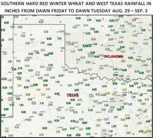
Kansas City, September 2 (World Weather Inc.) – Dryness in West Texas has been notably eased by rain in the past week. Dryland cotton production areas needed the moisture more than most other areas and although the rain amounts were light they were extremely important. In the meantime, central parts of West Texas received a good soaking rain which should carry many crops in that region through the balance of the growing season unless new bolls are set and those may not fully mature before the first autumn freeze arrives. In the meantime, Tropical Storm Lorena off the west coast of Mexico promises to bring additional rain to West Texas this weekend.
East Canada Prairies, Upper U.S. Midwest Frost Later This Week
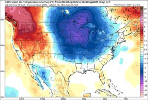
Kansas City, September 1 (World Weather Inc.) – Two shots of cold air will push through eastern Canada’s Prairies this week associated with a repeating pattern that World Weather, Inc. has been monitoring since last November. Last week’s cold weather was associated with this same cold pattern and it should reach a peak late this week and early in the weekend. Wednesday will be the first round of cooler than usual weather in the eastern Prairies while Friday and Saturday will be cold again over some of the same areas. Portions of the upper U.S. Midwest will see some frost and a few freezes Thursday morning with another opportunity for frost in the upper Midwest and Great Lakes region Sunday and Monday of next week.
U.S. Plains Rain Beneficial For Hard Red Wheat Planting
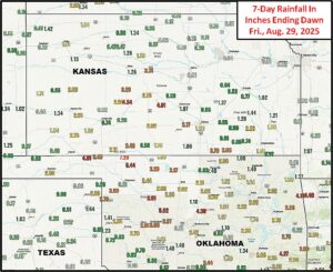
Kansas City, August 29 (World Weather Inc.) – Rainfall was highly variable across the central and southern U.S. Plains during the past week. Several areas in Oklahoma and Kansas received multiple inches of rain that significantly bolstered soil moisture. While the rain is welcome for those planting winter wheat in the coming weeks, precipitation was ill-timed for the maturing summer grains and other crops produced this time of year. Spotty rain and thunderstorms will continue through early next week before drier weather evolves later next week. The rain will improve planting potentials for hard red winter wheat across the main production areas. Late-season development of the summer crops will improve or remain favorable as well.
Weekly Citrus Weather for Tuesday, August 26, 2025
Kansas City, August 26 (World Weather Inc.) – Florida’s citrus areas saw waves of rain during the past week. With more precipitation on the way during the coming week, citrus potentials will remain favorable. Mexico’s citrus areas also saw several waves of monsoonal rain during the past week. Northeastern Mexico will start to dry down in the coming days despite some spotty rain, though citrus conditions will remain favorable. East-central and western Mexico will have ample moisture to maintain aggressive growth as well. Brazil’s citrus areas will have opportunities for spotty rain, though no major farming delays are expected.
U.S. Cool Weather To Protect Summer Crop Yields
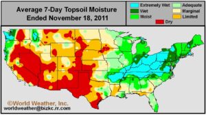
Kansas City, August 25 (World Weather Inc.) – Unseasonably cool weather in the U.S. Plains, Midwest and Delta may slow down crop development rates this week and early next week, but that may turn out to be a blessing for many areas. Soil moisture is quite limited in the Delta and the western Tennessee River Basin and some of that dryness has been creeping into Missouri, southern Illinois and other areas east into Ohio and Kentucky. The cool weather is going buy some of these drier areas some precious time this week by slowing down plant moisture demand and conserving subsoil moisture while soybean and late season corn are moving through the filling stage of development and beginning to mature. Yield potentials would likely slip notably lower if temperatures were warm to hot without rain in the drier areas, but keeping temperatures cool can make a huge difference while crops wait for greater rain next week.
Tropical Storm Fernand Poses No Threat To Land; Disturbance Near Windward Islands
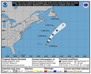
Kansas City, August 24 (World Weather Inc.) – Tropical Storm Fernand developed over open water in the Atlantic Ocean during the weekend and the storm poses no threat to land as it moves north northeast from a position well east of Bermuda. In the meantime another disturbance was moving toward the Leeward Islands; though, it only has a 30% potential for becoming a tropical cyclone as it moves into the Caribbean Sea.
World Cotton Weather For Friday, August 22, 2025
Kansas City, August 22 (World Weather, Inc.) – World cotton production has been moving along relatively well this year. India, China and Pakistan have seen some very good weather and should yield relatively well. The U.S. Delta crop has struggled and rain in the dryland areas of West Texas has not been up to par in the most important southwest. Despite some erratic rain in Mexico and below normal rainfall in Mali, production from both Mexico and West Africa should be favorable this year. Rain prospects are good for Australia later in the year and the harvest of cotton in Brazil is advancing in a favorable environment.
Weekly Citrus Weather For Tuesday, August 19, 2025
Kansas City, August 19 (World Weather Inc.) – Florida’s citrus areas again received timely rain during the past week. Citrus country will trend drier than normal during the coming week as Hurricane Erin tracks nearby and helps restrict precipitation. The need for irrigation will likely increase, though citrus prospects will remain favorable. In Mexico, much of the main production areas will have several opportunities for rain during the coming week. Precipitation in northeastern Mexico will be well-timed and will maintain a good outlook for most crops. Brazil’s citrus areas will be seasonally dry and farming activity should advance swiftly.
2005 U.S. Summer Weather Still Parallels 1948, 1969 and 2002
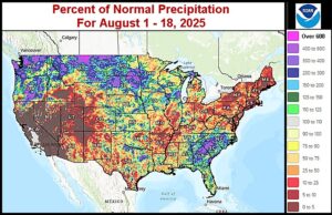
Kansas City, August 18 (World Weather Inc.) – Cyclical weather continues to dominate North America this year and we have seen this illustrated multiple times in the past few years as well. The parallels have been nothing short of amazing. Earlier this year, our weather was following that of 1968, a neutral ENSO year that had a La Nina-like winter similar to that of 2025. In more recent weeks, another parallel has evolved in which three post solar maximum sunspot years were identified as being very similar to July 2025. Those three years were 1948, 1969 and 2002 each of which were similarly identified in the solar cycle without significant influence from ENSO or other large scale weather phenomena. World Weather, Inc. took the parallel from July and applied it to August and used that as a forecasting tool. August is not over, but notice the parallel that is continuing in the images below. This parallel may hint at September weather as well.
Erin to Become Intense Hurricane; Not Likely A land Threat
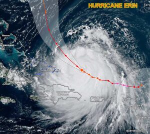
Kansas City, August 17 (World Weather Inc.) – Hurricane Erin reached Category Five intensity briefly early this weekend and has weakened to Category Three today. The storm will intensify again early this week and should be back to Category Four overnight and during the day Monday. Some weakening will begin again Tuesday into Wednesday. The storm’s movement is quite similar to that of Friday and is still unlikely to make landfall in eastern North America or Bermuda. However, the storm’s wind field will expand greatly and rough seas and some breezy conditions will impact the east coast of the United States and eventually a part of southeastern Canada coastal areas later this week. Damaging weather, however, should stay out to sea.
Lower U.S. Midwest, Delta Rain Next Week Very Important
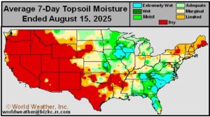
Kansas City, August 15 (World Weather Inc.) – Soil moisture today was rated short to very short in much of the Delta and portions of the Tennessee River Basin. Conditions are not quite as dry (yet) from central and southern Missouri into southern Illinois and Kentucky; however, accelerated drying will occur in these areas this weekend and early next week raising the need for timely rain. Rain is advertised to scatter across the lower Midwest, Delta and Tennessee River Basin, but its distribution may be a little disappointing and that may raise some concern over soybean and other late season crop conditions and production potential.
Weekly Citrus Weather For Tuesday, August 12, 2025
Kansas City, August 12 (World Weather Inc.) – Florida’s main citrus areas received frequent rain during the past week with some northern counties receiving more than 6.00 inches of rain. The region will trend drier than usual during the coming week and many groves will dry down. However, ample moisture in the soil combined with additional rain and irrigation will maintain a good outlook for the citrus. In Mexico, the northeast corner of the country dried down during the past week. These citrus areas will continue to dry down in the coming days and the need for timely rain will increase later this month. East-central and western Mexico will otherwise see favorable citrus conditions. A few locations in Brazil’s citrus areas saw nighttime temperatures drop to the 30s Fahrenheit over the weekend. Soft frost occurred in few pockets, though most of the production region was not impacted and there was no damage.
Tropical Storm Erin Forms West Of Cabo Verde Islands
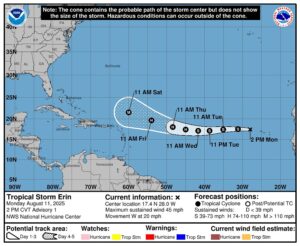
Kansas City, August 11 (World Weather Inc.) – Tropical Storm Erin has formed over open water immediately west of the Cabo Verde Islands and it will move to the west for the next couple of days while slowly intensifying. The storm is expected to pass northeast of the Greater Antilles this weekend as a major hurricane. The system will turn to the west northwest as it becomes a hurricane and it is likely to pass between Bermuda and the U.S. Atlantic Coast during mid- to late-week next week. The storm will become very large and will have to be closely monitored as it moves over the western Atlantic close to North America and Bermuda.
Derecho Reaches Minnesota After Moving Across North Dakota
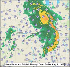
Kansas City, August 8 (World Weather Inc.) – A large cluster of thunderstorms that evolved in Montana Thursday afternoon advanced across much of North Dakota and far southeastern Saskatchewan, Canada to southern Manitoba and western Minnesota overnight. The storms produced damaging wind, hail and heavy rainfall. The system will likely be classified as a Derecho, although an assessment of the wind damage will need to be made before the event is officially classified as a Derecho. This is the second Derecho of the season with the first event reported last month in South Dakota, southwestern Minnesota and parts of Iowa.
Central U.S. Heat Unlikely To Go Beyond Plains Until Next Week
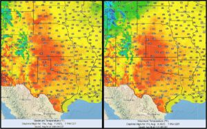
Kansas City, August 6 (World Weather Inc.) – A mini heatwave is evolving across the central and southern Great Plains and it will last into the weekend. Temperatures of 95-108 degrees are likely with Friday afternoon hottest. The heat will stress livestock and crops while restricting human activity and raising the demand for supplemental cooling fuel. However, the event will not last long enough to be of much concern and the heat is unlikely to advance very far out of the Great Plains due to a passing cool front late this weekend and early next week. Strong wind speeds are expected during the heat event. Next week will bring on another round of excessive heat and this time some of the heat will reach into the Midwest.
Lower, Eastern U.S. Midwest, Delta Drying Into Mid-Month
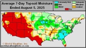
Kansas City, August 5 (World Weather Inc.) – Drying continues to evolve across the U.S. Delta and some immediate neighboring areas in the lower Ohio River Basin and Tennessee River Basin. After an unusually wet spring, most of the Delta and Tennessee River Basin have been drying out just like that of previous post solar maximum and lunar cycle years and like that of the neutral ENSO year 1968. The drying trend is expected to prevail through the middle of August because of changes in weather across North America and in the tropics. The lower and eastern Midwest may also experience some drying during this period of time, although subsoil moisture will support crops favorably. That makes the second half of August weather extremely important for timely rain in soybean, sorghum, cotton and other late season crop production areas.
Weekly Citrus Weather For August 5, 2025
Kansas City, August 5 (World Weather Inc.) – Florida’s citrus region received rain on a frequent basis during the past week. Temperatures were slightly above normal, though no major impacts were suspected. Rain will continue to be scattered across the main citrus areas during the coming week. In Mexico, the northeast corner of citrus country received little to no rain while east-central and western Mexico received timely precipitation. A similar weather pattern will occur during the coming week with additional drying expected in the northeast. The need for timely rain will increase later this month for much of northeastern Mexico. Brazil’s citrus areas will have a few opportunities for light rain during the coming week. No major harvest delays are expected.
Tropical Storm Dexter Forms east of North Carolina
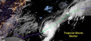
Kansas City, August 4 (World Weather Inc.) – The first in a series of tropical disturbances to evolve in the Atlantic Ocean Basin in the next couple of weeks has already become Tropical Storm Dexter. The storm was well east of North Carolina and it will move away from North America while intensifying early this week. No other tropical cyclones were noted in the Atlantic Ocean, Gulf of America or Caribbean Sea, although there is some potential for new development later this week.
Weekly Citrus Weather for Tuesday, July 29, 2025
Kansas City, July 29 (World Weather Inc.) – Florida’s citrus areas received seasonal rainfall on a frequent basis during the past week. With waves of rain and thunderstorms continuing on a frequent basis during the coming week, citrus prospects will remain favorable. In Mexico, the northeastern production areas dried down while east-central and western Mexico received timely monsoonal rain. Northeastern Mexico will again receive little to no rain during the coming week and the need for rain will increase. Other production areas in Mexico will again receive monsoonal rain on a frequent basis. Brazil’s citrus areas will trend dry or mostly dry in the coming days. Farming activity will continue with few disruptions.
Weekly Citrus Weather For Tuesday, July 22, 2025
Kansas City, July 22 (World Weather Inc.) – Florida’s citrus areas again saw a mix of rain and sunshine during the past week. Additional rain will occur during the coming week and will maintain a good outlook for the citrus. In Mexico, monsoonal rain continued to be scattered across the main production areas. Northeastern Mexico will trend drier than normal during the coming week and the need for more significant rain will increase late this month and early August. Other locations will have ample moisture to maintain aggressive growth. Brazil’s citrus areas will only have a few opportunities for light and erratic rain during the coming week. Farming activity will advance around the rain.
U.S. Weekend Rain Maintains Good Midwest Soil Moisture
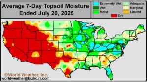
Kansas City, July 21 (World Weather Inc.) – Sunday’s soil assessment for the United States reflects the abundant rain that occurred during the weekend. Most of the Midwest has unusually good soil moisture for this time of year. There are a few pockets of dryness in Michigan and other areas in the Great Lakes region and a few other random pockets, but in general for the 21st day in July the moisture profile still looks good enough to carry corn through its filling process. Timely rain will still be needed for soybeans and even though timely rain is advertised for the next couple of weeks there will be some areas that will dry out and they will have to be monitored for mid- to late August when soybeans are in their most critical moisture demand stages of development.
U.S. Oppressive Heat, Humidity To Raise Human, Livestock Risk
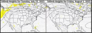
Kansas City, July 17 (World Weather Inc.) – Weather in the central and eastern United States this spring and summer was mostly very pleasant. Very few bouts of excessive heat, persistent dryness or other adversity occurred and crop development has been advancing quite favorably. Changes are forthcoming that will bring a period of hotter temperatures and high relative humidity that will probably stress animals and outdoor human activity more than it will threaten crops. Nonetheless human and animal health concerns will be rising this weekend and continue through all of next week and into a part of the following weekend as a result of building high pressure aloft. A decrease in rain frequency will occur for a few days while temperatures are warmest, but as the ridge shifts to the east in late July and early August some relief is expected.
Weekly Citrus Weather Tuesday, July 15, 2025
Kansas City, July 15 (World Weather Inc.) – Florida’s citrus region received rain on a frequent basis during the past week. Waves of rain will continue during the coming week, though rain totals will be a little lower compared to recent weeks. Long-term production potentials remain relatively favorable due to the additional rain. Mexico’s citrus areas also received monsoonal rain on a frequent basis during the past week. Northeastern Mexico missed out on the most significant rain and additional rain would be welcome. East-central and western Mexico will see a good mix of rain and sunshine during the coming week while portions of northeastern Mexico continue to dry down. Brazil’s citrus areas will be mostly dry during the coming week. Farming activity will advance with few disruptions.
World Corn Weather For July 15, 2025
Kansas City July 15 (World Weather, Inc.) – One of the primary reasons for corn futures prices to be so low is the favorable production situation that is prevailing in the United States, eastern Canada and China. Much of Europe (outside of France the lower Danube River Basin) is seeing good weather as well. India’s production potential is looking good while trouble areas outside of those noted above are largely confined to portions of Ukraine and Russia’s Southern Region while harvest conditions in Brazil, Argentina and South Africa are very good.
West Texas, Central U.S. Plains To See Another Wet Week
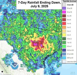
Kansas City, July 10 (World Weather Inc.) – Waves of erratic rain were noted in the U.S. Southern Plains since early July. The rain has been beneficial for the main cotton, corn, sorghum and other summer crop areas in Texas, Oklahoma and southern Kansas. With more rain on the way during the coming week, the environment will remain favorable for most summer crops. There is need for drier and warmer conditions in some cotton areas. Winter wheat harvesting is over three-quarters of the way finished in both Texas and Oklahoma and the anticipated spotty rain in those areas may slow harvesting and general fieldwork at times. Winter wheat quality impacts should be minimal as the rain will be too spread out over time to significantly impact crop conditions and much of the harvest is already complete.
South U.S. Post Solar Max. Years Get Less Late Summer Rain
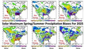
Kansas City, July 10 (World Weather Inc.) – Frequent abundant to excessive rains have been reported this year from the U.S. Delta and Tennessee River Basin into Texas and Oklahoma. This anomaly has been substantial, but it is very interesting to note that many of the post solar maximum and the lunar cycle years have all had a tendency to show similar conditions as pointed out in the spring and summer outlooks for 2025 released earlier this year. The wet bias may not be over, although the greatest rain anomaly in the coming week will be in West Texas, Oklahoma and parts of Kansas rather than in areas from the heart of Texas into the southeastern states as has been case at times this year. Drier- and warmer-than-usual weather may evolve for a while later this month into early August, but the wet bias may not be quite done for summer.
Central US. Midwest Rain Deficit Having Low Impact On Crops
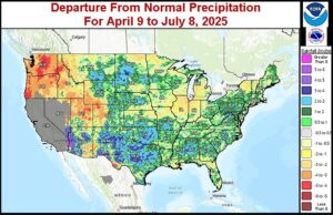
Kansas City, July 9 (World Weather Inc.) – It is easy to become complacent about weather anomalies when timely rain occurs routinely over multiple weeks. That has certainly been the case for the heart of the Midwest where rainfall remains lighter than usual, but crop conditions are rated quite favorably with a huge production potential. This, once again, reiterates the idea that rainfall anomalies are not nearly as important to yields and production if the rain that does fall is timely and supported by seasonable temperatures. Some areas from northeastern Missouri and southeastern Iowa to western Michigan and northwestern Illinois are still reporting below normal rainfall, but as long as timely rain continues and temperatures are seasonal the impact on production may be minimal.
Weekly Citrus Weather For Tuesday, July 8, 2025
Kansas City, July 8 (World Weather Inc.) – Florida’s citrus areas saw rain and thunderstorms evolve on a frequent basis during the past week. The rain helped maintain a good environment for aggressive citrus growth. Additional rain will occur during the coming week that will continue to support a good outlook for the citrus. In Mexico, monsoonal rain was noted across the main production areas during the past week. Monsoonal rain will persist on a frequent basis during the coming week and will continue to promote a good environment for the citrus. Brazil’s citrus areas will be mostly dry during the coming week. Harvesting will advance swiftly.
U.S. Soil Moisture, Rainfall To Carry Crops Into Late July
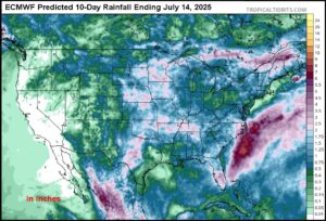
Kansas City, July 3 (World Weather Inc.) – Weather in the United States, and in most areas around the world, can turn around in a very short period of time during the summer due to warm temperatures and quick drying. However, this year’s weather pattern is likely to maintain a favorable outlook for corn, soybean and other spring and summer crops from the Great Plains into the Midwest into late July. Weather over the next ten days to two weeks should be sufficient enough to maintain a favorable moisture profile down deep into the ground for the next two weeks protecting corn development potentials unless there is some kind of unexpected heat wave that evolves and prevails. August weather will be more important for soybeans, sorghum and cotton than July weather.
Weekly Citrus Weather for Tuesday, July 1, 2025
Kansas City, July 1 (World Weather Inc.) – Florida’s citrus region received rain on a frequent basis during the past week with more on the way in the coming days. The environment will remain favorable for aggressive growth. Mexico’s main citrus areas also received monsoonal precipitation on a frequent basis during the past week. Additional monsoonal rain during the coming week will maintain a good outlook for the citrus. In Brazil, a cold front dropped temperatures into the 30s Fahrenheit for portions of Sao Paulo last week. While frost was possible, no significant damage or loss was suspected.
North America July Weather To Begin Favorably
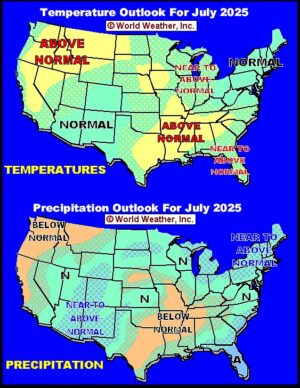
Kansas City, July 1 (World Weather Inc.) – North America weather in July is expected to begin favorably due to a strong jet stream limiting the potential for a blocking high pressure ridge. The strong jet stream observed during June influenced weather throughout the Northern Hemisphere this spring and it is unlikely to slow enough to support a strong ridge of high pressure for a least another week or two; however, seasonal changes in weather will lead to a slower jet stream later in July and there is some potential for warmer and drier conditions – at least for a little while and that could have some significant influence on crop development in the southern and eastern Canada Prairies and perhaps a few areas in the U.S. as well.