
Evening U.S. And South America Weather Update For September 28, 2026
The first ten days of the evening model run were dominated by a change in weather patterns over North America allowing a stronger ridge of high pressure to evolve over the west. This created a stronger northwesterly flow pattern aloft limiting precipitation in the Plains, Midwest, Delta and southeastern states which would be good for summer crop maturation and harvesting after recent wet weather in the Plains and western Corn Belt.
Despite some of the changes suggested this evening, the general theme of weather in South America did not change much. Rain still begins in center west Brazil this weekend and continues periodically next week. The model was too wet in interior southern Brazil during much of the two-week forecast and that was seriously overdone. Argentina, like center west Brazil, will be trending wetter this weekend into next week.
Mid-day U.S. and South America Weather Update For September 28, 2026
This content is for members only
Hurricane Polo to Make Landfall Over Baja California Sur Later Today
Hurricane Polo is expected to make landfall over Baja California Sur later today, and will make a second landfall over Sonora by Tuesday afternoon. Heavy rainfall and hurricane force wind speeds could impact fruit that is grown over the peninsula, and could pose risks for cotton quality in Sonora if conditions verify. Those with interests in northwestern Mexico should monitor this situation closely. Tropical Storm Rachel’s outer bands may bring heavy rainfall to southwestern Mexico, though this forecast will also need to be monitored closely as current forecast amounts are subject to change in the next few days. Other tropical systems being monitored in the Atlantic and Central Pacific will not be any threat to land.
World Weather Outlook For September 28, 2026
Click On The Link To Download The World Weather Outlook
Updated 3-Day Precipitation and Temperature Maps For North and South America For September 28, 2026
Click on the link to see some of the most recently updated precipitation and temperature maps for North and South America. These are some of the more popular maps, but remember to look at our map gallery for a more complete listing of past weather maps for around the world.
Selected 3-Day Precipitation and Temperature Maps For September 28, 2026
Click on the link to see some of the most recently updated precipitation and temperature maps for North and South America. These are some of the more popular maps, but remember to look at our map gallery for a more complete listing of past weather maps for around the world.
World Weather To Watch For September 27, 2026
Click On The Link To Download The Full Report
Northeast U.S. To See Waves Of Rain; Flooding A Concern
Kansas City, September 25 (World Weather Inc.) – Several areas in New England are bracing for a nor’easter that will bring significant rain to the region overnight tonight into early next week. Coastal flooding and a strong storm surge may limit ocean travel and damage coastal property from New Jersey into Massachusetts. While crop impacts will be minimal, harvesting and general farming activity will likely be disrupted or delayed for several locations across New England due to the waves of rain. Flooding for areas farther inland over New England should be minimal. Drier weather later next week will help gradually reduce flood waters along the New England coastline.
South America and South Africa Weather Outlook Maps For September 25, 2026
Click Here to download two-week weather outlooks for South America and South Africa.
West Texas, Oklahoma Cotton To Trend Wetter
Kansas City, September 24 (World Weather Inc.) – Cotton production areas from eastern New Mexico and West Texas into Oklahoma, the Texas Panhandle and southwestern Kansas have had a challenging summer. Most of the region suffered from excessive heat, but a large part of the production region was also suffering from chronic dryness. Irrigated areas may have suffered too. Now, the forecast is beginning to change and for the coming week there is a good potential that rain will fall more abundantly and frequently. The moisture will be good in bolstering soil moisture for winter crops and grazing conditions, but not so welcome for cotton fiber quality. Some discoloring is possible and there is some growing concern about Hurricane Polo and its remnants possibly bringing excessive rain to a part of the region.
U.S. Hard Red Wheat Areas To Receive Much-Needed Rain
Kansas City, September 23 (World Weather Inc.) – Hard red winter wheat planting is underway for the U.S. central and southern Plains. Much of the planting region is abnormally dry or under the influence of drought with much of Oklahoma and the Texas Panhandle dealing with extreme or exceptional drought. Waves of rain are slated for these areas through the middle of next week. While rainfall will be too light to break the drought, short-term establishment conditions will improve. The rain will otherwise slow or delay the maturation and early season harvest of summer crops. Western sections of the U.S. Corn and Soybean Belt will also see waves of rain that will often slow or delay maturation and harvesting.
Western Atlantic Storm To Impact Shipping In NE U.S.
Kansas City, September 22 (World Weather, Inc.) – A strong mid-latitude trough of low pressure aloft bringing relief from heat to the central and eastern U.S. this week should spawn a strong surface storm system in the western Atlantic Ocean later this week. This storm should evolve in a similar fashion to a nor’easter and it could acquire tropical or subtropical characteristics as it strengthens. The northeastern U.S. and/or southeastern Canada may be impacted by strong winds and power outages along with coastal flooding from the storm surge associated with this storm. Delays to shipping and stress to the region’s infrastructure are likely if the storm comes near the region. The various computer forecast models are predicting a wide variety of solutions for this storm and confidence is low for its eventual track.
U.S. Midwest Harvest To Advance Slowly From Waves Of Rain
Kansas City, September 18 (World Weather Inc.) – Harvesting of corn and soybeans is underway in portions of the U.S. Midwest. Rainfall during the past week was enough to slow or delay early-season harvesting and general fieldwork in several areas, most notably from Iowa, Nebraska, and northern Missouri into portions of northern Illinois, Indiana, and Ohio. Another active weather pattern through the end of next week will continue to limit harvesting and general fieldwork with exceptions for southern Illinois and neighboring locations. Precipitation will otherwise be welcome for any crops that are not yet maturing. A drier weather pattern will likely evolve late this month into early October, which should gradually improve harvest conditions for much of the Midwest
U.S. Southern Plains To See Relief from Hot, Dry Conditions
Kansas City, September 18 (World Weather Inc.) – Nearly two months of excessive heat and drier-biased conditions have caused significant crop and livestock stress in the U.S. Southern Plains this summer. Some short-term relief is possible in the coming days as a frontal system bringing scattered showers and thunderstorms and cooler temperatures enters the region next week. Despite relief, the driest areas in the eastern Texas Panhandle and west-central Oklahoma are expected to remain drier biased. NOAA’s 90-day seasonal precipitation outlook, released Thursday, suggests the potential for wetter than normal conditions October through December. The forecast is based largely on past strong El Nino events and World Weather, Inc. believes there is merit to the outlook. If the long-range forecast verifies, it would bring greater relief to drought and pasture conditions, as well as improve support for the planting and establishment of winter crops.
Atlantic Hurricane Season Lines Up With Previous El Nino Years
Kansas City, September 11 (World Weather Inc.) – Hurricane season so far in the Atlantic Ocean has been below normal, which is typical during El Nino years. There have only been five named storms since the season started June 1 and today marks the record with the latest development of a hurricane in the Atlantic Basin during the satellite era, according to Accuweather. Development of a tropical wave is not expected through the end of next week and conditions may be less than favorable into the second week of the outlook. The chances for another below normal hurricane season are high for the Atlantic Basin, though there will still be chances for tropical activity late this month into October and November.
Barge Traffic Should Be Slowed By Low Mississippi River Levels
Kansas City, September 10 (World Weather, Inc.) – Drought in the Upper and Lower Mississippi River Basins and the Upper Missouri River Basin along with recent limited rainfall from portions of the Great Plains into the lower Midwest has caused significant water level declines along the Lower Mississippi River. Water levels are still high enough to support barge traffic along the Lower Mississippi River with a few restrictions, but that should soon change. Runoff from rain Wednesday and that of today in the lower Midwest is not likely to be great enough to prevent the river from reaching the low water level threshold near Cairo, Illinois by Friday night. Significant restrictions to cargo size and tow limits for barges occur once the river drops to the low water threshold.
U.S. Pacific Northwest Water Reservoirs Low as Drought Persists
Kansas City, September 9 (World Weather Inc.) – Drought conditions and low water reservoir levels continue to impact the U.S. Pacific Northwest crop areas. Severe to exceptional drought persists in Oregon and the Snake River Valley, with eastern Oregon’s water reservoirs largely being under 10% capacity. Drier-biased conditions are expected to persist for the foreseeable future. A minor rain event expected to bring trace amounts to 0.35 inch of rain to parts of Washington and Oregon will occur in the coming days, but these amounts will not be enough to make a significant difference in the drought conditions if the event verifies. Heavier or more consistent rain will be needed across the crop region to improve overall conditions.
U.S. Hard Red Winter Wheat Country Needs Significant Rain
Kansas City, September 4 (World Weather, Inc.) – Hot to excessively hot temperatures and limited rain in recent weeks dried out the soil in much of hard red winter wheat country. The weather pattern will not change much during the next ten days and planting delays are likely in much of the region. There is still plenty of time for planting to occur, but the widespread, significant rain needed to bolster soil moisture to ensure favorable conditions for germination and establishment is not expected for at least ten more days and likely longer.
U.S. South Plains To See One More Week Of Extreme Heat (Includes 30-Day Outlook)
Kansas City, September 2 (World Weather Inc.) – Meteorologic autumn has begun with the start of September, but it is still very much summer like in the south-central United States where persistent heat will remain for at least another seven days. Many folks in the southern Plains are making comparisons to 2011 because of the high number of 100+ degree Fahrenheit days that have occurred this summer. Cooling in the higher latitudes will begin to pressure the dominating ridge of high pressure in the middle of North America next week and it will just be a short period after that before temperatures start to finally cool down temporarily. Additional warm weather is probable this month across the southern states, but it should not be as oppressively hot as that recently. That statement is valid for the Delta as well as the southern half of the Great Plains.
Tropical Storm Edouard Brings Heavy Rain to East Texas
Kansas City, September 2 (World Weather Inc.) – Heavy rain accompanied Tropical Storm Edouard into far eastern Texas late Tuesday and overnight. Some flooding resulted and a few reports of high wind gusts, but overall, the storm came inland without much serious impact. The storm has been downgraded to a tropical depression and will dissipate overnight tonight as it drifts through eastern Texas.
Tropical Storm Edouard Unlikely To Have Much Impact
Kansas City, September 1 (World Weather Inc.) – Tropical Storm Edouard was expected to move across the upper Texas coast near the Louisiana border later today, but its impact is unlikely to be very great. Maximum sustained wind speeds were reaching 40 mph prior to dawn today and they may reach 65 mph prior to landfall, according to the U.S. National Hurricane Center, but the amount of rain and wind anticipated in eastern Texas and Louisiana may be less than what occurs from large thunderstorm clusters. Not much agriculture is in east Texas to be harmed and most of Louisiana’s rice and sugarcane are far removed from the storm’s greatest impact. Little to no damage to personal property, infrastructure or agriculture is anticipated, although a little coastal wind damage is possible and local flooding will follow the storm’s center into eastern Texas tonight into Thursday.
Texas Panhandle Rain Induces Temporary Relief From Dryness
Kansas City, August 28 (World Weather, Inc.) – Rain and cooler temperatures the past few days have improved conditions for cotton in the Texas Panhandle and portions of southwestern Oklahoma, but with at least another week of hot and mostly dry weather these improvements will be temporary. After weeks of hot to excessively hot temperatures and limited rain cotton, and other summer crops, suffered permanent damage and whatever improvements result from rain this week will not likely be dramatic. The rain was welcome for winter crops as well, but much of the moisture will soon be lost to evaporation leaving dryland areas in need of much more rain. Peanut harvesting should get off to a good start in early September.
U.S. Northwest Corn Belt To See Limited Relief From Dryness
Kansas City, August 25 (World Weather, Inc.) – Rain so far this month in the drier areas of the western Corn Belt has been highly beneficial in eastern Nebraska where significant improvements in crop and soil conditions occurred. Meanwhile, precipitation has been much more limited from the eastern Dakotas into northwestern and north-central Iowa and western and central Minnesota where stress to crops and declines in yield potentials have increased. Much of the remainder of the Corn Belt has seen adequate to excessive rain and some central and eastern areas are in need of drier, and in some areas, warmer weather. During the next week, showers will bring welcome, but mostly light, rain to some of the drier areas in the northwest inducing small corn and soybean yield increases in a few areas before drier weather resumes Aug. 31-Sep. 7. Meanwhile, the remainder of the Midwest will also see some shower activity with seasonably warm and dry weather between rounds of rain likely adequate to induce beneficial drying in much of the region.
Most of Southern U.S. To See Another Ten Days Of Heat
Kansas City, August 21 (World Weather, Inc.) – Hot and often dry weather in recent weeks across the southern U.S. has caused serious crop and livestock stress resulting in lower animal weight gains and notable potential yield losses for all crops, but especially unirrigated crops. The heat has rushed some plants to earlier-than-usual maturity resulting in early harvesting. Punishing heat will continue for at least another week to ten days from the southwestern U.S. desert region through the southern Plains. Meanwhile, the Delta and the Southeast U.S. will see some moderation in temperatures while remaining warmer than normal.
World Fires: Biggest Burns Central Africa, Brazil and NE Russia
Kansas City, August 21 (World Weather Inc.) – It is not unusual for wildfires to occur at any time of the year in various places in the world, but it seems that the number and intensity of fires today are quite significant. Looking at satellite imagery and noting some of the internet commentary the most extensive, active, fires today seem to the be in central and south-central Africa, northeastern Russia and in Brazil. However, fires of significance are also impacting the western United States and in various other locations in a more random and isolated manner across other North America, Europe and Asia locations.
U.S. Midwest Needs Warmer, Drier Weather For A While
Kansas City, August 19 (World Weather Inc.) – Corn and soybean prospects remain relatively favorable across the U.S. Midwest as rain fell across the region during the past week. Flooding was noted in many areas at one time or another from eastern Nebraska through parts of Iowa to Illinois, Indiana and Ohio that may have damaged some of the crop and soybeans. The week’s derecho also caused some significant wind damage for corn in some areas. The crops now need warmer and at least some temporary drier weather to support better corn filling and maturation conditions and soybean pod filling. Alternating periods of rain and sunshine are slated for much of the Midwest through the middle of next week. The rain will be light enough to allow some runoff to continue taking the region’s excess moisture away while maintaining enough soil moisture to support long term crop development. However, temperatures will be milder than usual resulting in both slower evaporation rates and slower crop development. Warming will be needed.
U.S. Northern Plains Weather Favors Crop Maturation, Harvesting
Kansas City, August 19 (World Weather, Inc.) – Warmer-than-normal temperatures and infrequent rain during the next ten days to two weeks will allow crop maturation and harvesting to continue at an above-average pace after hot and dry weather at times during the summer sped up crop development. Not all crops are mature, however, and corn, soybeans, and sorghum would benefit from rain even though there is still some moisture left in the ground for crops to utilize. Meanwhile, significant rain is needed to improve prospects for winter wheat planting.
World Oilseeds Weather For Tuesday, August 18, 2026
Kansas City, August 17 (World Weather, Inc.) – Oilseed production around the world seems to be doing well especially for an El Nino year. However, El Nino events are far more impactful on tropical and subtropical regions of the world which helps to minimize the potential for big production cuts for soybeans, groundnuts, canola and sunseed since they ae produced mostly in the higher latitudes. There is some concern over production cuts in western and southern Europe. Weather problems elsewhere do not seem to be hugely problematic, although rain is needed in southern India, eastern Mexico, the southern U.S. Plains and Delta as well as the Black Sea region.
U.S. Midwest Soybeans, Corn Need Drier Weather
Kansas City, August 14 (World Weather Inc.) – Stormy weather in the Midwest this week has saturated the soil and induced flooding and frequent bouts of severe thunderstorms. Needless to say, it has been a stressful week for crops and producers from South Dakota and Nebraska through the heart of Iowa to interior northern and central Illinois and much of India to Ohio. The ground is saturated with moisture and some pools of standing water are present which raises concern over soybean conditions and to a lesser degree corn. Improving weather is coming, but probably not until late this month and when it improves it may not be completely dry. In the meantime, more rain this weekend and during mid-week next week will see to it that improvements are slow to come.
U.S. Delta Drying To Expand Into Portions Of Southeast U.S.
Kansas City, August 11 (World Weather, Inc.) – Hot weather and limited rain in recent weeks from the Delta through Mississippi has firmed up the soil stressing late season crops and lowering yields. In contrast, the remainder of the Southeast U.S. has experienced regular rain that induced significant drought relief and improved conditions for crops. The two-week outlook includes a continued lack of rain from the Delta through Mississippi and into portions of Alabama where temperatures will remain hot through at least late next week. The remainder of the Southeast will see daily showers that will be timely and will slow drying rates, but with warm to hot temperatures in place most of region is not likely to receive enough rain to prevent net drying from taking place.
U.S. Southern Plains, Delta Crops Facing Heat, Moisture Stress
Kansas City, August 10 (World Weather Inc.) – The U.S. southern Plains and Delta dried down significantly during the past week. A large section of Texas and Oklahoma into the northern Delta were dry or did not receive enough rain to counter evaporation. Coarse grains, oilseeds, cotton, and other crops may have been stressed in the hottest and driest areas. At least another week of dry and warm to hot weather is slated for these areas this week. Additional drying will occur and drought will spread and intensify. Heat and moisture stress will continue for the crops that are still in the development stages. Concern for production losses will increase.
El Nino Update: What Has Been Lost Or Gained?
Kansas City, August 4 (World Weather Inc.) – El Nino continues present across the tropical region of the eastern Pacific Ocean and it has been in place for the past two months. Even though it is early in the event there has not been much adverse weather in the world to impact agriculture production, thus far. That does not mean that El Nino has not had an influence and that does not preclude the potential for adverse weather in the next few months. Drought is evolving in Indonesia and rainfall has been below normal in southern Thailand, north-central Myanmar, southern India, the Greater Antilles and in parts of Mexico and Central America. However, there does not seem to be much serious impact from the event thus far. El Nino’s persistence over the next few months could easily change that and the situation must continue to be monitored.
U.S. Plains Set To Dry Down After Recent Rainfall
Kansas City, August 3 (World Weather Inc.) – Several areas from Colorado, Nebraska, and northern Kansas into South Dakota, Minnesota, and a few pockets in North Dakota received timely rain during the past week. The precipitation likely improved development conditions for the short-term, though additional rain is needed to support better late-season growth. The Southern Plains and Delta were dry or received limited rainfall and concerns remain high for production cuts this season. The Midwest and southeastern states saw a good mix of rain and sunshine during the past week and crop conditions remained relatively good. The Plains and Delta will only have a few opportunities for erratic rain this week with temperatures again climbing above normal at times. Aggressive drying is expected and may continue to stress crops in the driest and warmest areas. The Midwest and southeastern states will see a mix of erratic rain and sunshine. Many areas will not receive enough rain to counter evaporation. Most will still have enough moisture to promote good growth in the short-term.
Hot and Dry Conditions Persist in U.S. Pacific Northwest
Kansas City, July 30 (World Weather Inc.) – Drought in the western United States has expanded and intensified impacting crop areas from Wyoming and Idaho into Washington, Oregon and some northern California locations. All crops have been stressed at times with the irrigated fields producing most favorably. There is concern about long term water supply especially in Oregon where water shortages are most significant. Weather conditions in August are unlikely to change much and that will likely perpetuate some occasional heat and moisture stress for crops and livestock throughout the region.
Central, SW Canada Prairies And NW U.S. Plains Still Drying
Kansas City, July 30 (World Weather Inc.) – Canada’s Prairies has been a land of contrast this summer with portions of northern Alberta canola and wheat country much too wet along with a few areas in western Manitoba and east-central and far northern Saskatchewan. In contrast, the central and southwestern Prairies have been steadily drying recently. Crop production losses have occurred because of drowning in some of the wettest areas and now there is fear of some yield loss for crops in central through southwestern parts of the region as well as in parts of Montana and portions of the Dakotas. These areas will see another two weeks of similar conditions raising a little more concern about this year’s production.
U.S. Midwest August Weather May Be Similar To July
Kansas City, July 29 (World Weather Inc.) – July proved to be a more stressful month for crops and livestock in the U.S. Plains and for producers in Canada’s Prairies when compared to weather expectations for the month. The U.S. Midwest, Delta and southeastern states did not have ideal weather, but the problems nature provided there were far from the calamity that was feared by some. July is about over and looking at August weather, World Weather, Inc. is not seeing a tremendous amount of new threatening weather. August should be similar to that of July in the sense of most U.S. Midwestern states seeing timely rain and seasonable temperatures. There will be more stress and strain on livestock and crops in the Great Plains and southwestern Canada’s Prairies.
Livestock, Crop Stress To Climb In U.S., Western Europe
Kansas City, July 24 (World Weather Inc.) – July has already been a tough month on agriculture in North America and western Europe and this is expected to continue through the coming week. Waves of heat and some notable dryness have evolved in portions of both continents raising the potential for “some” notable declines in production for “some” grain, oilseeds, sugarbeets and livestock weight grains. Europe dryness has been much more prolonged than that in portions of the U.S. and as for Canada, much of the early spring was marred by excessive rain and cool weather rather than heat and dryness.
World Cotton Weather For Wednesday, July 22, 2026
Kansas City, July 22 (World Weather Inc.) – Recent reports from China have implied that the production year has been a tough one in 2026 and that the crops have suffered the consequences. World Weather, Inc. believes that those statements are a little out of line with reality. The production year in Xinjiang has been quite favorable except for a period of extreme heat June 30-July 6 and again this past weekend, but the remainder of the production year, so far, has been largely favorable. In the meantime, India has been and may continue to be the biggest surprise with timely rain impacting some of the northwestern production areas, but that statement will only be validated if significant rain falls later this week and into early next week as advertised. West Texas cotton is still struggling with dryness in some areas, but its production will all be about August weather. In the meantime, harvesting in Argentina is winding down and production in Brazil has been favorable. Some much needed rain will soon fall in the southeastern U.S. relieving the Carolinas from drought.
Tropical Storm Bertha To Have Low Impact On Agriculture
Kansas City, July 21 (World Weather Inc.) – Tropical Storm Bertha formed over the northeastern Gulf of America last evening and its expected path of movement has not changed greatly from that of Monday’s forecast. The storm is expected to have a low impact on agriculture from the Florida Panhandle to the upper Texas coast, but it will produce some moderate to heavy rain and some windy conditions in coastal areas. Sugarcane in southern Louisiana is the primary crop to be impacted.
U.S. Southern Plains, Delta Will See Limited Rain
Kansas City, July 20 (World Weather Inc.) – Significant drying is slated for the U.S. southern Plains and Delta this week as a high-pressure ridge builds over North America. These areas will trend mostly dry or receive limited rainfall while temperatures surge above or well above normal at times. Many areas in Texas and Oklahoma will experience several 100+ degree Fahrenheit daytime highs with pockets warming above 110 degrees. The Delta will not be as hot compared to the southern Plains, though daytime highs will warm well into the 90s on a frequent basis. The Delta has some moisture to support new growth during the next few days. However, conditions may deteriorate as the ground firms. A degradation in crop conditions is also expected for much of the southern Plains due to heat stress.
U.S. North Plains, Southern Canada Prairies Crop Risk Rises
Kansas City, July 20 (World Weather Inc.) – Waves of excessive heat and inadequate shower activity over the past ten days has seriously reduced soil moisture across the northern U.S. Plains and southern parts of Canada’s Prairies inducing the season’s greatest region of moisture stress outside of the U.S. Carolinas. A few showers and thunderstorms will impact a part of this drier region during mid- to late-week this week with a slight chance for follow up rain early to mid-week next week. However, the precipitation will be surrounded by periods of excessive heat and dryness negating the beneficial aspects of the rain for many areas. A general soaking of rain must occur soon to stop the decline in dryland wheat, barley, oat, canola, corn, soybean, sunseed and sugarbeet yields.
U.S. Plains Drought Likely To Expand, Intensify
Kansas City, July 17 (World Weather Inc.) – Precipitation was highly variable across the United States during the past week. The southern Plains and Delta into the southeastern states and southern Midwest, along with portions of Montana, saw a good mix of rain and sunshine. The central and northern Plains into other locations in the Midwest were dry or received limited rainfall. Grain, oilseed, cotton, and other crop conditions are generally good from the heart of the Midwest and Delta into portions of the southeastern states that have seen drought eased or reduced this summer. Summer crop conditions are otherwise variable in the Plains and Carolinas due to ongoing dryness. A high-pressure ridge will help restrict rain across the Plains, western Corn Belt, and Delta through the end of next week. The Delta and western Corn Belt will have some moisture to support new growth while aggressive drying is slated for the Plains. Crop conditions may deteriorate in the driest locations. The central and eastern Midwest into southeastern states will see a good mix of rain and sunshine. Development conditions will either improve or remain relatively favorable.
Serious Flooding In South-Central Texas Second Year In A Row
This content is for members only
Extreme Heat In North U.S. Plains; Drought Expansion Likely
Kansas City, July 12 (World Weather Inc.) – Excessive heat developed in the northern Plains during the weekend as expected with extreme highs to 115 degrees Fahrenheit Sunday afternoon. Temperatures may not be quite so extreme this week, but they will still be in the 90s to well over 100 while little to no rain falls resulting in an expansion of drought from South Dakota, Nebraska, Wyoming and Montana northward a part of both North Dakota and Minnesota. Rain is possible in the second week of the forecast, but it is unclear how significant that will be. Partial relief will come with the rain (favoring the northeast part of the region), but the situation warrants a very close watch.
U.S. North Plains Heat, Dryness Pose A Threat to Agriculture
Kansas City, July 10 (World Weather Inc.) – A strong high-pressure ridge is slated to build over central North America this weekend and will prevail through at least the middle of next week. As a result of the ridge, a heat dome will build over the U.S. northern Plains and several neighboring locations during this time. Temperatures will soar well above normal with many areas in Montana, Wyoming, the Dakotas, The Snake River Valley in Idaho and Oregon, and southern fringes of the Canadian Prairies warming near or above 100 degrees Fahrenheit for several days. A few extreme highs will reach up near 113. Heat stress will impact all crops and livestock in this region and concern is rising because of limited rainfall for at least ten days even though the hottest temperatures will abate sooner. Wyoming and several areas in Montana and the Dakotas are already abnormally dry or in varying stages of drought and the hot daytime temperatures will further exacerbate the situation.
NW U.S. Corn Belt, Northern Plains Drying; Heat Stress Likely
Kansas City, July 8 (World Weather Inc.) – An impressive ridge of high pressure will build through the Rocky Mountain region to the U.S. Great Plains and a part of southern Canada’s Prairies over the next few days. The ridge will be most dominating during the late weekend through the early to middle part of next week before shifting west into the Rocky Mountain states late next week and into the following weekend. The ridge will suppress rainfall for a week to nearly ten days and it will induce several days of very warm to hot temperatures. The result of this mix will be a notable dry down period for the northern U.S. Plains and northwestern Corn and Soybean Belt that will stress dryland crops especially in areas of low soil moisture which includes portions of Nebraska, South Dakota, southwestern Minnesota and northwestern Iowa. Late July and early August weather will need to be wetter and milder to protect production potentials.
West Texas Rain A Bit Sporadic, Little Change Likely
Kansas City, July 1 (World Weather Inc.) –Several cotton, corn and sorghum production areas in the Southern Plains received timely rain in June that led to good establishment and early-season development. However, West Texas and a few locations in East Texas are dealing with drought and need more significant rain for ideal long-term production potentials. West Texas and a few locations in the Blacklands cotton region will have opportunities for spotty rain and isolated thunderstorms during the coming week. Resulting rainfall will be too light to significantly improve the moisture profile, but it may promote good growth in the short-term. South Texas and the Coastal Bend area will be mostly dry. Cotton potentials may be relatively favorable in the short-term outside the driest areas of West Texas. The need for timely rain will be high heading into the second half of July.
U.S. July Weather To Support More Rain
Kansas City, July 1 (World Weather Inc.) – This week’s high-pressure ridge aloft over the Midwest is not a feature that will be around very often during July – at least not in the eastern part of North America. The ridge is expected to relocate to the west over the Rocky Mountain region and high Plains this weekend and prevail there through much of this month. Some brief movements to the east and west will occur, though the end result will prove to be timely for crop areas in the Midwest. Rain during July is expected to be routine enough in the heart of the Midwest to keep temperatures seasonable and crop development advancing well. A boost in monsoon moisture is also expected in the western United States and Montana will see some periodic rain events.
U.S. Heat To Benefit Some Crops And Stress Livestock, People
Kansas City, June 26 (World Weather Inc.) – Changing North America weather this weekend will allow for stormy weather to return in Canada as temperatures in the western United States drop well below normal. The chilly conditions and wet bias in those areas will contrast from a mini-heatwave that is expected in the central and interior eastern United States as a high-pressure ridge evolves. Notably high relative humidity and temperatures in the 90s to near and slight above 100 Fahrenheit will result in serious livestock stress while also impacting human outdoor activity. Crops, however, may benefit from the warmer weather – at least for a little while after a lengthy period of frequent rain and mild temperatures. A close watch on the northwestern Corn Belt may be warranted since that area has been drier biased for a while. In the meantime, recent wet weather has the moisture profile mostly favorable in other Midwest, Delta and central Plains crop areas.
Summer Heat Building Up In Southern U.S. Plains
Kansas City, June 23 (World Weather Inc.) – Hot temperatures developed in the southern U.S. Plains during the long holiday weekend with extremes reaching 111 Fahrenheit from Edwards Plateau to the Big Bend area of Texas. The heat mellowed out in recent days, but the southern Plains are likely to heat up again over the next week and become a heat source for other areas in the central and eastern United States for a while. That will translate into excessive heat advisories and warnings for both people and livestock from the central and southern Plains into the Midwest and Delta.
Tropical Storm Arthur’s Rain To Threaten Low-Lying Crops
Kansas City, June 17 (World Weather Inc.) – A very disorganized tropical weather system near the Texas coast has been named Tropical Storm Arthur by the U.S. National Hurricane Center. The storm is mostly a big rain event and it has already produced some significant rain this week while over northeastern Mexico and southern Texas. The system has been over open water southeast of the Texas coast long enough to acquire more tropical moisture and develop a little better circulation resulting in the tropical storm declaration. Arthur is not likely to strengthen much more before it moves back over land near the Houston and Port Arthur areas of Texas this evening and overnight. The system will then move through Louisiana before dissipating. In the wake of all this will be some impressive rainfall that will induce flooding of low-lying areas which may induce some property, crop and infrastructure damage from Louisiana to western Georgia the next few days.
Northern Mexico, Southern U.S. Flooding Possible This Week
Kansas City, June 15 (World Weather Inc.) – A weak upper-level low-pressure trough was noted over northern Mexico this morning. This disturbance will slowly shift from northern Mexico into Texas and Louisiana through mid-week, where conditions may allow for development into a weak, and brief, tropical disturbance. This system will further shift into the U.S. southeast later this week before tracking into the Atlantic Ocean over the weekend. Bouts of heavy rain are slated from northeastern Mexico through portions of South Texas and East Texas and eventually into Louisiana, Mississippi, Alabama, and neighboring locations. Flash flooding will be a significant concern, as will damaging winds. Damage to cotton, rice, and other grains and oilseeds will be possible for areas that experience severe flooding.
West Texas Received Timely Rain; Much More Needed
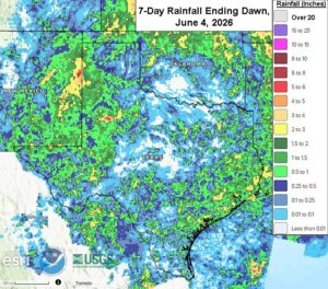
Kansas City, June 4 (World Weather Inc.) – Planting of cotton, sorghum, corn, and other crops is advancing across West Texas and neighboring areas. Timely rain during the past week marginally bolstered soil moisture and may have improved short-term establishment conditions. There is still a need for much more rain to completely break the drought and support ideal long-term production potentials. West Texas will have a few opportunities for erratic rain and isolated thunderstorms during the next few days. Resulting rainfall will be too light to counter evaporation. Establishment and development conditions may deteriorate, especially for dryland areas. Other cotton areas in Texas will see a mix of rain and sunshine as well. Cotton prospects are relatively favorable in the Blacklands region while conditions are more variable for South Texas and the Coastal Bend.
Driest U.S. Midwest Region To Get Needed Rain
Kansas City, June 3 (World Weather Inc.) – Planting of corn, soybeans, and several other crops is winding down in the United States. Significant rain fell over many production areas east of the Rocky Mountains in recent weeks and crop conditions slowly improved. Several areas in the Plains, Delta, and U.S. southeast were still under the influence of drought at the end of May, although significant relief had occurred in many areas. An active weather pattern is in store for the Plains, Midwest, and Delta through the middle of next week with waves of rain and thunderstorms to help keep soil moisture near current levels or improve it. One of the driest areas in the Midwest from northeastern Missouri and southeastern Iowa to Michigan will get needed relief while the southeastern states fail to get enough moisture for a serious improvement in crop or field conditions.
U.S. June Weather Outlook Perpetuates Some Midwest Drying
Kansas City, May 29 (World Weather Inc.) – Another week has come and gone across the U.S. Midwest with the region from northeastern Missouri and southeastern Iowa to southeastern Wisconsin getting little to no rain. The rain that fell across parts of Illinois and northwestern Indiana was also quite limited while southwestern Michigan received some welcome rain last weekend. As noted a week ago, the corridor from northeastern Missouri and southeastern Iowa to Michigan has had a tough time getting normal rainfall in recent weeks and that region will continue to dry down for at least another week. Areas to the east, from Michigan to the Ohio River Valley, may experience below normal precipitation into mid-June. June Weather in the Great Plains, Delta and southeastern states should occur routinely for the benefit of many crops.
U.S. May Weather Brings Dryness Concerns To Several Areas
Kansas City, May 22 (World Weather Inc.) – Precipitation so far in May has been quite varied across key U.S. crop areas. The bulk of the Midwest has had sufficient soil moisture to support spring planting and early season crop development, but there is some growing concern about dryness in several areas and a close monitoring of weather in the next few weeks is warranted. Certainly, the coming ridge of high pressure over central North America will be a concern for the next week to ten days. World Weather, Inc. does not believe the trends seen in this time period represent the summer pattern. More variety is coming, although that does not guarantee no ongoing pockets of dryness.
Wyoming, Montana Freezes Harm Sugarbeets
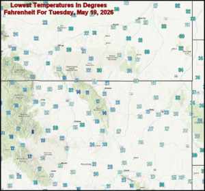
Kansas City, May 19 (World Weather Inc.) – Unusually cold temperatures this morning in Wyoming and Montana burned a considerable amount of new vegetative growth from crops and trees throughout the two states. The impact should have been minimal to low since most crops were not far enough advanced to be seriously harmed. With that said, though, Wyoming’s sugar beets were 40% emerged and vulnerable some of the coldest temperatures. Other crops may have been damaged, as well, though local conditions will dictate the overall impact. The cold weather will shift into the northern Plains tonight, but no serious harm is expected to crops there; though some newly emerged corn, soybeans, dry beans and sugarbeets could be impacted to some degree.
Northern, West-Central U.S. Plains Freeze Tonight
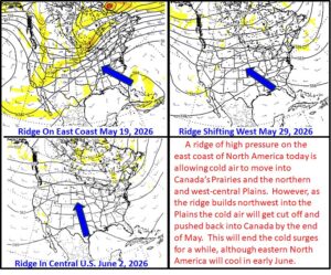
Kansas City, May 18 (World Weather Inc.) – Temperatures continue to gyrate at an impressive rate and over wide ranges this spring. Another wild swing in temperatures occurred over the past week with frost and freeze conditions impacting parts of the U.S. Midwest and Plains a little more than a week ago followed by extremes highs during this past weekend in the 90s to over 105 Fahrenheit in the heart of the Plains. Temperatures in the northwestern Plains reached into the 80s and over 90 briefly last week, but high temperatures in the southwestern Canada Prairies and the northwestern U.S. Plains during the weekend were stuck in the 30s and 40s. An additional fall in temperatures will occur tonight with portions of the northern west-central Plains back again into the frost and freeze range. This should be the last of the coldest nights for a while.
U.S. Midwest Warming To Improve Crop Emergence, Growth
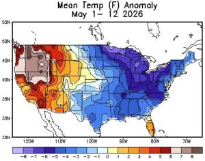
Kansas City, May 13 (World Weather Inc.) – Unusually cool weather in the U.S. Midwest, Delta and southeastern States this month has slowed crop development and drying rates. The impact of cool weather has been greatest on the Great Lakes region and central Midwest, although areas farther to the south were impacted as well. Warm weather is needed to stimulate quicker drying rates between rain events and to stimulate faster emergence, establishment and early growth. Temperatures will rise notably this weekend into early next week, but more cooling after that will reverse the trend and may come with some rain to slow fieldwork once again. Planting has advanced well so far this season, despite recent cooler biased conditions, but the warm up is needed to improve crop establishment and growth rates.
South America, South Africa, and Europe Weather Outlook Maps For March 2, 2026
Click Here to download two-week weather outlooks for South America, South Africa, and Europe.
Evening U.S. And South America Weather Update For March 2, 2026
The evening GFS model run in the United States decreased precipitation from central Texas northeast into Kentucky Saturday into next Monday. In week 2, precipitation was increased in the Carolinas, Virginia, and the northeastern Northern Plains March 12-14. Precipitation was decreased in week 2 from central Mississippi through northern Alabama March 10-12. The evening GFS model run in South America increased rainfall in northwestern Argentina Saturday into next Tuesday. In week 2, rainfall was increased across Argentina, Uruguay, Paraguay, and the western half of Brazil’s key production region March 15-17. Rainfall was decreased in week 2 in Paraguay and in central and southeastern Argentina March 12-14.
Mid-day U.S. and South America Weather Update For Mar. 2, 2026
This content is for members only
World Weather Outlook For Mar. 2, 2026
Click On The Link To Download The World Weather Outlook
World Weather To Watch For March 2, 2026
Click On The Link To Download The Full Report
Excessive Wind In NW U.S. Plains, SW Canada Thursday
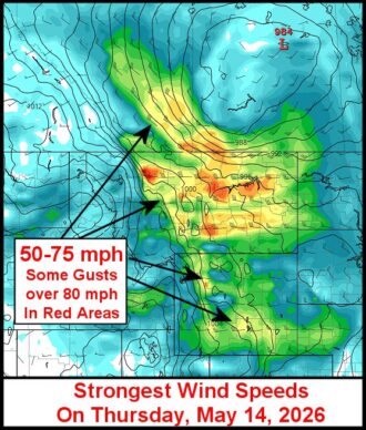
Kansas City, May 12 (World Weather Inc.) – Strong wind speeds have been a frequent occurrence in the U.S. Plains and a part of Canada’s Prairies this spring and another bout of that is coming Thursday. Wind gusts of 50-75 mph and possibly a little stronger will impact Montana, south-central and southwestern Saskatchewan and portions of eastern, central and southern Alberta causing some power outages and possible structural damage as well as being a threat to high profile vehicles moving across the region. Some windy conditions are also expected in Wyoming, western Nebraska and in a swath from interior western Texas to eastern parts of the Dakotas and western Minnesota.
U.S. Pacific Northwest Will Be Dry, Warm In Coming Days
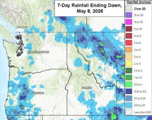
Kansas City, May 8 (World Weather Inc.) – Drought continues to impact portions of the Pacific Northwest, although water supply for irrigated land seems to be sufficient to support crops in those areas. Rain-fed wheat and barley production areas need rain and the coming week of warmer than usual temperatures and limited precipitation may further stress some of the unirrigated crops. Most of the winter wheat and barley is still rated favorably, but there is concern for dryland production. Drier and warmer than usual weather will prevail through the first part of next week. Rain potentials will increase toward the middle and latter part of next week with additional rain possible during the second week of the outlook. As long as the rain later this month verifies, short-term conditions for the spring grains will improve. Winter grain prospects will remain relatively favorable, especially in irrigated areas.
Central U.S. Facing Warmer Days; South Plains Hot
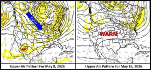
Kansas City, May 8 (World Weather Inc.) – Recent cold temperatures in the central United States have occurred as the atmosphere cycled through another episode of northerly winds aloft. Most of that cold will become concentrated on the northeastern parts of the nation and in neighboring areas of eastern Canada over the next week to ten days. In its wake will be some high-pressure ridge building aloft over the central parts of North America. This change will bring much warmer temperatures to central and western parts of North America and in particular the southern U.S. Plains, Great Basin and southwestern desert region. Hot temperatures are expected in parts of Texas and Oklahoma with some warmer than usual conditions expected to build into the remainder of the Great Plains as time moves along.
U.S. West-Central High Plains Freeze Wheat Impact Low
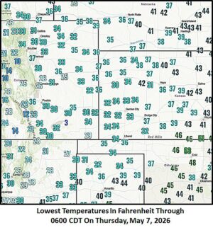
Kansas City, May 7 (World Weather Inc.) – A late-season frost and freeze event has occurred overnight in the U.S. west-central high Plains region from Colorado and southwestern Nebraska into western Kansas and the Oklahoma and northwestern Texas Panhandles. Freezes in Kansas may not have been hard enough for a long enough period of time to induce serious harm to the wheat crop, although an assessment will have to be made to determine its full impact. Some of the impact will not be fully understood until the harvest since the impact of such conditions often results in the sterilization of the plant’s reproductive parts leaving wheat heads empty of grain when the harvest occurs. Colorado was coldest and wheat was most immature and partially buried in snow across that state further reducing the impact.
U.S. Southeast, Delta To Get Additional Drought Relief
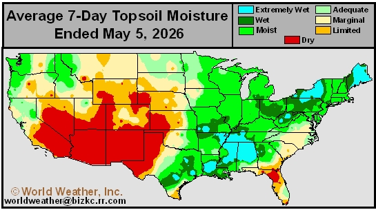
Kansas City, May 6 (World Weather Inc.) – Portions of the U.S. Delta and Tennessee River Basin received significant rain in the past week to ten days easing drought and improving crop and field conditions. However, the region still has some notable moisture deficits. Additional rain predicted in this coming week will be additive to the recent past rainfall to help further ease drought conditions and maintain a favorable or improving production outlook. Drought in the southeastern states is still quite serious and despite some needed rain falling this past weekend there is an ongoing need for much more moisture. The region from Northern Florida and southeastern Alabama to South Carolina will get some needed moisture in the coming week, but there will continue to be a need for more moisture. Establishment and early-season development conditions should slowly improve in the Delta and southeastern states; however, more rain will be needed later this month into early June to improve long-term production potentials for coarse grains, oilseeds, cotton, and other crops.
U.S. Hard Red Wheat Thursday Temperatures Drop Raising Risk
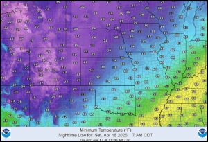
Kansas City, May 6 (World Weather Inc.) – An impressive pocket of cold air has been over the central United States for the past two days leaving temperatures well below normal for this time of year. Snow and rain are falling this morning in west-central portions of hard red winter wheat country keeping temperatures above the damage threshold; however, colder conditions are likely Thursday morning with clearing skies. The official forecast for low temperatures Thursday in the west-central high Plains is colder than advertised earlier this week raising the potential for some wheat damage.
West-Central U.S. Plains Freeze Thursday Raises Wheat Threat
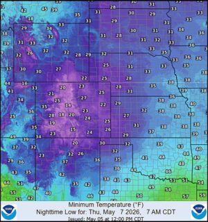
Kansas City, May 5 (World Weather Inc.) – How many lives does winter wheat have? Nine? It seems like this year’s wheat has been wiped out multiple times already by extreme cold in late January and mid-March. There have also been frequent freezes in recent weeks separated by some impressive heat. The frequent gyrations in temperature are stressful enough to plant life and then there is the drought to consider. Crops were planted favorably last autumn and were well established prior to dormancy. Since then, dryness has steadily worsened and the region’s drought in combination with temperature extremes has seriously stressed wheat and other crops in the central and southwestern Plains this year. One more bout of extremes is expected Thursday with morning temperatures falling into the middle and upper 20s Fahrenheit in Colorado and western Kansas. Could this be the last straw for a crop that is already rated poorly? World Weather, Inc. believes some damage is possible and the impact when added to all of the other problems will maintain a lower production year for the crop, but a true disaster is not likely.
Central U.S. Hard Red Wheat To See Rain, Snow Ease Dryness
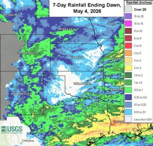
Kansas City, May 4 (World Weather Inc.) – An unusually late season snow event will impact eastern Colorado late tonight into Wednesday morning with a mix of rain and snow likely in wheat areas of western Kansas and a few in southwestern Nebraska. The moisture will be welcome and should ease dryness just a bit. Some improved wheat and summer crop conditions are possible in the areas that get the greatest moisture. Other areas in hard red winter wheat country are unlikely to see much improvement in crop or field conditions especially not in the southwest where dryness is most dominating. Texas and western Oklahoma crop areas are least likely to get relief from drought this week.
World Cotton Weather For April 30, 2026
Kansas City, April 30 (World Weather, Inc.) – Winter weather in the United States created drought of varying degrees of significance across its cotton production areas. Dryness reached a peak about ten days ago and since then many Delta and Texas cotton areas have either received rain or soon will. The same is expected for the southeastern U.S. while South Texas and northeastern Mexico will stay dry for quite a while along with the southwestern desert region of the U.S. In the meantime, cotton development and production potentials are high in Brazil while reductions in production are anticipated for Australia, China and Pakistan. The jury is still out on India’s cotton production this year since El Nino’s behavior will have much to say about the situation. Argentina crops have suffered a quality decline because or rain and the same may happen to a part of the South Africa crop due to rain during its harvest.
U.S. Delta Drought Eased By Recent Rain; SE Relief Coming
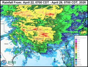
Kansas City, April 30 (World Weather Inc.) – Drought in the U.S. Delta and southeastern states became a bit extreme and notable earlier in April raising much concern about the growing season this year. Some timely rain of significance has evolved during the past week in much of the Delta and Tennessee River Basin and a small part of the southeastern states. Not all areas have been seriously eased from dryness, but improved crop and field conditions have resulted in many areas. This trend will continue into the weekend as one more weather disturbance impacts the region. This next weather event will bring greater relief to the lower Delta and a larger part of the Carolinas, southern Georgia and southeastern Alabama where there has not been much relief yet.
Frost, Freezes Return U.S. To Hard Red Winter Wheat Areas
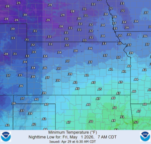
Kansas City, April 29 (World Weather Inc.) – Frost and freezes returned again to U.S. hard red winter wheat production areas this morning, but the impact on the more advanced wheat crop was minimal. Additional cold is expected Friday and Saturday that may threaten a few fields with minor damage. Most of the temperatures this weekend are unlikely to be quite cold enough for a long enough period to add more damage to the already drought-stricken crop, but readings will be close to the damage threshold for heading wheat and the situation will need to be closely monitored.
U.S. Midwest Frosts, Freezes Unlikely To Have Big Crop Impact
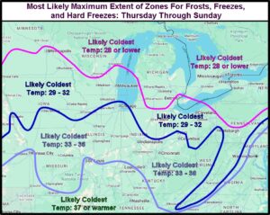
Kansas City, April 29 (World Weather Inc.) – An unusually cool air mass moving into the U.S. Midwest will lead to morning frosts and freezes later this week through Sunday. The cold air will reach its maximum southerly extent Saturday and Sunday mornings before notable warming begins to return from the west. Light freezes will occur as far south as central Iowa through northern Ohio and frosts could get as far south as central Missouri and parts of Kentucky, at least in some low-lying fields. Hard freezes will be limited mainly to Wisconsin, Michigan, and northern crop areas of Minnesota. A few crops may be impacted by the cold, but damage is unlikely to be serious enough to cut into winter wheat yields or require much, if any, replanting of early emerged corn and soybeans.
U.S. Hard Red Wheat Missing Rain At The Worst Time
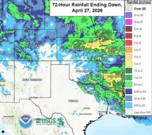
Kansas City, April 28 (World Weather Inc.) – A system that brought rain and thunderstorms to portions of the U.S. Plains, Midwest, and Delta this past weekend brought some precipitation to portions of Kansas and Nebraska. However, several of the main hard red winter wheat areas in the central and southern Plains missed out on meaningful precipitation, southern and western Kansas in particular. Drought is firmly in place across hard red wheat country and there is still a pressing need for more rain. Rain is predicted for Texas and southern Oklahoma later this week, but much of Kansas and northern Oklahoma may be missed again. Other opportunities for showers and thunderstorms will come and go during the following week to ten days, but the odds are not favoring a general soaking and that implies ongoing crop stress and a rising risk to production. The only good news is that there should not be any excessive heat during the next ten days.
East U.S. Cooling To Help Raise Rain Potential In Drought Areas
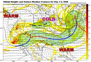
Kansas City, April 24 (World Weather Inc.) – An impressive bout of cold air in Canada today producing snow across much of the Prairies will eventually shift to the eastern parts of North America. As the cold air spreads across the U.S. Midwest and into the mid-South and southeastern states it will help set the stage for much needed rain in many of the drier areas in the southern states; including the southern Plains and Delta. This rain potential is growing for the latter part of next week and could lead to improved wheat and hay development as well as improved planting moisture for summer crops.
U.S. Late April Cooling To Bring Rain Into Delta, Southeast
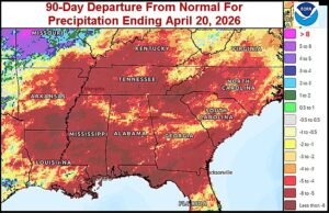
Kansas City, April 20 (World Weather Inc.) – A weekend cold airmass moving across the northern United States has brought frost and freezes to the Pacific Northwest, the northern and western Great Plains and northern Midwest. The cold will concentrate on New England and the Middle Atlantic Coast States tonight. A short-term bout of warming is then expected with well above normal temperatures possible again in the central United States just before a new surge of late April and early May cooling takes place. The cooler air advertised for the last days of April and early May should push a couple of frontal systems into the drought-stricken Delta and southeastern states offering to stir up some shower and thunderstorm activity that will bring much needed relief. Dryness should resume later in May after the cold abates.
U.S. Freezes Tonight Through Tuesday To Impact Agriculture
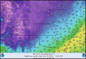
Kansas City, April 17 (World Weather Inc.) – Cold temperatures occurred Thursday and Friday mornings in the U.S. Pacific Northwest impacting some deciduous fruit trees as well as small grains and a few other crops. The cold was not that usual for mid-April, but given all of the warmth that has been around in recent weeks the impact may have been a little greater than usual. The same cold airmass will trek across the contiguous United States tonight through Monday night inducing more frost and freeze events and possibly inducing additional crop damage. Most of the impact should be greatest on flowering fruit trees and shrubs, but there maybe some negative impact on winter wheat in hard red winter wheat areas in the western high Plains region as well.
Severe Weather Outbreak To Impact The Central U.S. Today
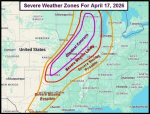
Kansas City, April 17 (World Weather Inc.) – Significant severe thunderstorm activity is expected today from central Oklahoma northeast into Wisconsin, Illinois, and eastern Iowa. All modes of severe weather will occur with this including large hail, damaging winds, and tornadoes. The tornado concern is greatest from eastern Iowa into Wisconsin, the damaging wind threat is most significant from eastern Kansas into southeastern Iowa, and large hail will occur locally within this corridor. Damage to personal property is likely and potentially to some early season crop development too. Some areas of flash flooding will also occur and fieldwork delays will result.
U.S. Hard Red Wheat Country Dry For Another Week
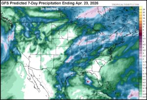
Kansas City, April 15 (World Weather Inc.) – Drought is intensifying across the U.S. central and southern Plains. A significant amount of the hard red winter wheat is rated poor or very poor and there is a pressing need for rain. The High Plains region will remain mostly dry through the middle of next week with temperatures often running above or well above normal for this time of year. Eastern sections of Oklahoma and Kansas will see periods of rain and thunderstorms that will alleviate some of the dryness, though not enough to completely fix the drought. Wheat conditions will likely deteriorate and the need for abundant rain will remain high heading into early May. There is some potential for some rain briefly in the second half of next week. Planting conditions for the cotton, corn, and other summer crops may also be less than favorable to poor in West Texas and other areas in the High Plains region until significant rain fells.
U.S. Midwest Frost/Freeze Risk Rises As Cold Cycle Returns
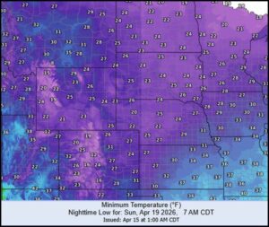
Kansas City, April 15 (World Weather Inc.) – Unusual cold in late January and the first days of February and again during mid-March was part of a repeating cold cycle that has been impacting eastern North America periodically since November. It is due to return in the last days of April and early May. However, the cold will not be as potent this time around as it was in mid-March, but nonetheless frost and freezes may return to portions of the Midwest. Recent computer forecast model runs have also suggested a good chance for frost and freezes in the Midwest and Great Plains this weekend into next Monday morning.
Western U.S. Hard Red Wheat Misses Rain; Relief Unlikely
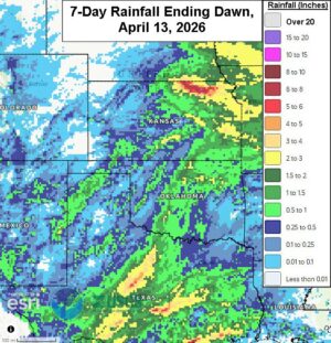
Kansas City, April 13 (World Weather Inc.) – Rain in hard red winter wheat areas during the past week behaved as expected with a restricted amount of dryness relief in the western parts of the production region. Much of the west-central and northwestern production areas are advertised to remain dry or mostly dry during the next ten days while a few showers occur in the Texas Panhandle. The best weather conditions for winter wheat will continue from north-central Texas through central Oklahoma to eastern production areas in Kansas where frequent rain is expected. Additional opportunities for rain may evolve later this month and in May and “eventually” there will be some greater rain in the driest areas, but it may come a little late for the best yields in 2026.
U.S. Southeast Drought Not Wavering
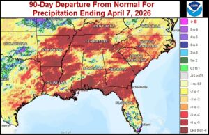
Kansas City, April 7 (World Weather Inc.) – Drought is ongoing in a large section of the U.S. southeastern states and Delta. These areas received some needed rain in the first week of April, though amounts were too light to seriously change the moisture profile in most locations. There is still a pressing need for significant rain to support better early-season planting and establishment of the coarse grains, oilseeds, cotton, and other crops. Both regions will continue to experience an inadequate amount of rain during the coming week to make any changes. The Delta may trend wetter April 14-20, but the southeastern states will remain quite dry except possibly in Virginia and North Carolina where some rain is possible next week. Warm daytime temperatures and a lack of rain will promote aggressive drying across both regions. Early-season germination and emergence conditions will be poor as the drought prevails, and in some cases intensifies.
Northern Plains Snowstorm To Slow Travel, Stress Livestock
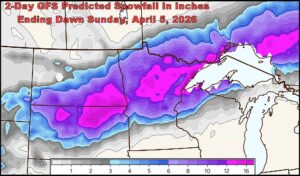
Kansas City, April 2 (World Weather Inc.) – An expected trough of low pressure moving aloft over the north-central United States Friday and Saturday will bring substantial snowfall to the northern Plains. Snow accumulations will be great enough to shutdown travel in portions of the Dakotas and northern Minnesota and livestock stress is likely as well. The storm will not be followed by extreme cold which should help the animals deal with the storm, though still stressful.
April Weather Unlikely To Break Western N. America Dry Trend
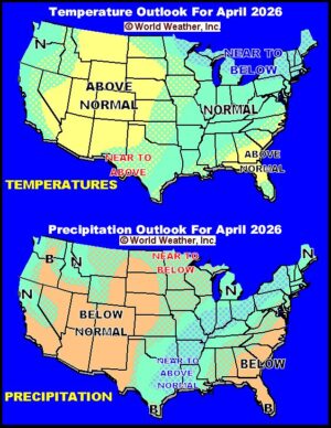
Kansas City, April 1 (World Weather Inc.) – Western portions of North America are unlikely to break away from the drier-than-usual conditions that dominated the autumn and winter months. Most of the U.S. Rocky Mountain region, Great Basin and southwestern desert region will be drier than usual in April as will portions of southwestern Canada. Wetter-biased conditions are expected in the first part of April in the western Delta, southeastern Great Plains and a part of the Midwest, but the second half of the month should be drier biased once again as an old familiar weather pattern resumes. Temperatures will be warm in western parts of North America, cooler biased in eastern Canada and mild at times in the U.S. Midwest.
United States Bracing For Severe Weather, Snow
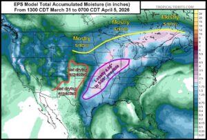
Kansas City, April 1 (World Weather Inc.) – An active spring-like weather pattern will impact parts of the United States agricultural areas in the coming days. Two upper-level disturbances will track across North America through the end of the weekend that will promote significant rain and storms for the Midwest and portions of the Delta and southeastern states. Significant amounts of snow will also fall in portions of the Northern Plains due to these disturbances. Early-season fieldwork may be delayed by the precipitation event and the cool weather that should follow keeping some fields wet a little longer. Localized flooding will be possible from Missouri into the central Midwest and some of the snowfall in the northern Plains will impact travel and stress livestock. The moisture will be welcome as many areas are still in a drought or abnormally dry. However, some of the resulting rainfall will be too light in the Delta and southeastern states end drought. Two waves of severe thunderstorms producing hail, damaging wind and tornadoes will occur today into Thursday and again Friday into Saturday from Texas to Iowa.
U.S. Delta, Midwest Will See Rain Potentials Increase
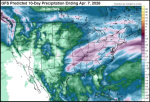
Kansas City, March 27 (World Weather Inc.) – Drought continues to expand and intensify across a large section of the United States. Precipitation during the past week favored the Pacific Northwest and portions of the eastern Midwest while a high-pressure ridge promoted dry or mostly dry weather in the remaining agricultural areas. With planting season rapidly approaching, the need for significant rain is high for a large section of the country. Winter grain areas are also in need of rain to improve development conditions. The ridge will continue to restrict precipitation through the end of the weekend before a series of disturbances advances across central and eastern North America next week. Rain will impact the U.S. Delta and portions of the eastern Midwest and southeastern states with some improved soil moisture. The Plains and western Midwest will receive limited precipitation and will continue to dry down. Rainfall will be too light to completely erase the drought, even in areas that receive the greatest amount of precipitation. The need for abundant rainfall will remain high heading into mid-April.
Central U.S. Faces One More Round Of Heat This Week
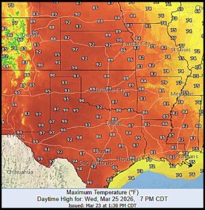
Kansas City, March 22 (World Weather Inc.) – A heatwave in the western United States late last week through Saturday was nothing short of amazing. Hundreds of record temperatures were noted Friday and Saturday. Some of the records were for the date and others were set for the warmest temperatures ever recorded in the month of March. The heat was most significant in the central Plains and areas southwest into the desert areas of North America; however, hard red winter wheat and livestock in the Plains were most impacted. Temperatures cooled down Sunday and additional cooling is expected Monday; however, a new round of hot weather is expected Tuesday through Thursday before a more extended period of less oppressive heat begins later in the week.
Drought Worry Rising Over Western North America
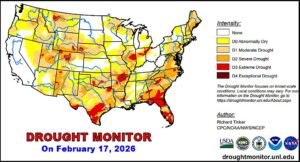
Kansas City, March 20 (World Weather Inc.) – This week’s unusual heat wave in western North America has peaked interest in the weather outlook for this spring. Worry has begun to rise over the longer-range forecast because of the degree of dryness present from southwestern Canada’s Prairies through much of the western United States. Drought is also prevailing in portions of the U.S. Midwest, Delta and southeastern states. The outlook for spring continues to be a little disconcerting and a closer watch on the atmosphere is warranted over the next few weeks.
Historic March Warmth To Impact West U.S. Today – Saturday
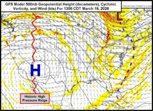
Kansas City, March 18 (World Weather Inc.) – An impressive early season heatwave is anticipated in the western United States over the next few days as an unusually strong high-pressure ridge develops aloft over the region. This high-pressure ridge is one of the strongest noted for this time of year and will have characteristics similar to that of a mid-summer event. That implies hundreds of record high temperatures are going to be set in the western United States and some cities in the southwest will possibly break their records for excessive heat so early in the season. Some of the temperatures will be the warmest recorded for the month of March and probably surpass old records for early season heat set in April as well. The excessive heat and record setting conditions may last for two to three days. The extremely anomalous warmth will occur from California and the southwestern desert region into the northern Rocky Mountain region and portions of the northern Plains. Stress to livestock and winter crops is quite likely; including those in in hard red winter wheat areas, most of West Texas and the northern Plains. Cooler air will arrive Sunday with some additional anomalous warmth later next week.
U.S. Winter Storm Summary; Fruit, Vegetable Damage Likely
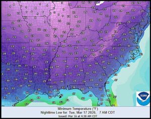
Kansas City, March 16 (World Weather Inc.) – An impressive cold wave will bring damaging temperatures to fruit and vegetable crops in the southeastern United States Tuesday morning as the weekend major winter storm winds down and abates from the nation. Some wheat damage is also possible, although the wheat crop will recover except in the most advanced fields. Bitter cold this morning in hard red winter wheat production areas likely shocked crops, but permanent damage is not very likely except possibly in a few more advanced plants in the far southwestern Plains. The weekend storm hampered travel, stressed livestock and induced some power outages. Impressive wind speeds, significant snowfall and a plethora of damaging wind and hail reports were all associated with the weekend winter storm.
U.S. Summer Weather 2026 Will Improve After Rough Spring
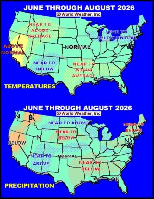
Kansas City, March 13 (World Weather Inc.) – Weather in North America continues to show scars from the multi-year drought that impacted the continent from 2020 through 2023. Many areas from northern Mexico through the United States to parts of Canada are still having a tough time shaking off persistent drought. Spring weather will add a little more concern about conditions in several areas because of wild swings in temperature bringing late season frost and freeze events, multiple rounds of severe weather and intense late winter storms. The wild weather swings will be most significant in the eastern United States at the same time drought and dryness remain a concern in the Rocky Mountain region and a part of the Great Plains. Summer, however, is expected to bring opportunity for change; including greater rain potentials from the Rocky Mountain region through the Great Plains and into the Midwest. The Delta and southeastern states, though, may have some lingering dryness to deal with.
Major Winter Storm To Impact U.S. Saturday Into Monday
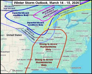
Kansas City, March 13 (World Weather Inc.) – A major winter storm will impact the Northern Plains and especially the Corn Belt this weekend with blizzard conditions, significant snow accumulations, a zone of freezing rain and sleet, and a line of severe thunderstorms which will also include the Delta region. The greatest snow accumulations will occur from central and southern Minnesota through Wisconsin and northwestern Michigan. Very strong wind speeds will occur with the snow and this combination will lead to nearly impossible travel during and slightly after the event. Notable livestock stress is expected as a result of this winter storm too. The strong non-thunderstorm related winds will lead to power outages and personal property damage. The line of thunderstorms will also likely cause power outages and some property damage.
U.S. Midwest Blizzard To Bring Freezes To Delta, SE States
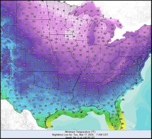
Kansas City, March 11 (World Weather Inc.) – Have you had enough weather volatility yet? Severe thunderstorms during the past couple of days have brought large hail damaging wind and tornadoes to parts of the Midwest and southern Plains. The severe storms were a byproduct of unusually warm and humid conditions that built up across the southern Plains, Delta and lower Midwest at the same time a strong cold front pushed into the region bringing cooler and drier air. The volatility is expected to continue with another short-term bout of warming coming up late this week followed by a deep pool of cold air moving south from the arctic. This second round of cold will be potent and should induce a blizzard across the northern Midwest and then hard freezes southward into the central Plains, Delta, Midwest, Mid-South and southeastern states. Travel delays and livestock stress will come from the blizzard while the cold will set back wheat development in many areas throughout the south.
Eastern U.S. Cold Weather Next Week Will Return In Late April
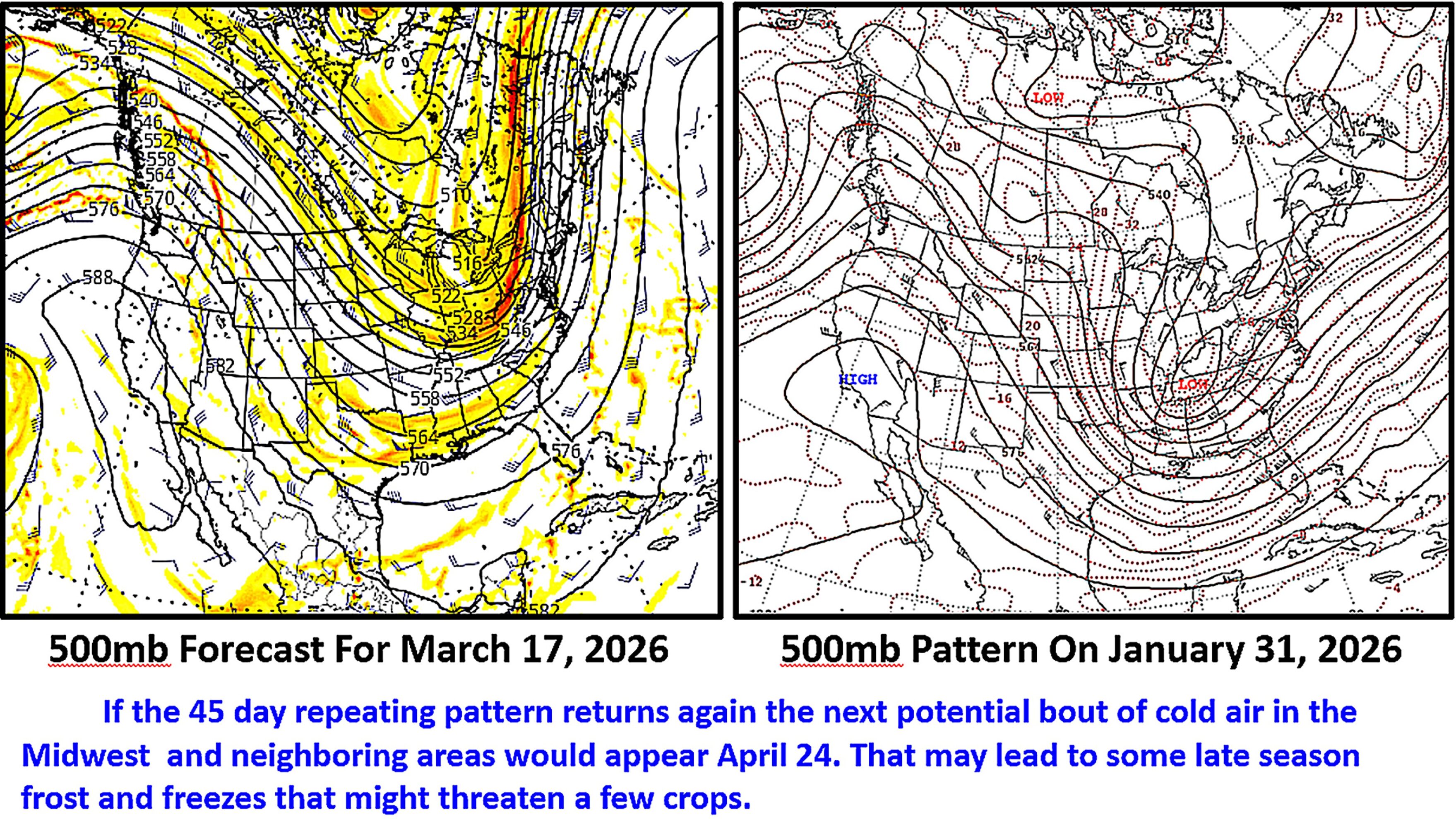
Kansas City, March 17 (World Weather Inc.) – Cold arctic air is pooling in northern Canada once again and it will drop into the Canadian Prairies this weekend. Changes in the jet stream at the end of the weekend and early next week will then force some of the cold air south into the Midwest, Delta and southeastern states during the early part of next week. This weather change is part of a repeating weather cycle that should reappear in the last days of April and early May. Frost and freezes are expected to associate with both surges of cold. Next week’s cold will burn back some new vegetative growth in wheat production areas while that which occurs in late April and early May could induce some greater damage to winter and spring crops.
U.S. Midwest Flood Threats Will Increase In Coming Days
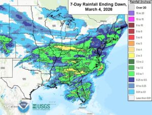
Kansas City, March 4 (World Weather Inc.) – Much-needed rain was noted in the United States southeast and portions of the Midwest during the past week. Resulting rainfall was too light to completely fix the drought that intensified over the winter, though precipitation was still welcome where it fell. An active weather pattern is slated for a large section of the United States east of the Rocky Mountains through the middle of next week. Waves of rain will improve the moisture profile and may promote flash flooding from eastern sections of Texas and Oklahoma through the northern Delta and into portions of the eastern and central Midwest. The moisture profile will improve significantly for these locations. However, early-season fieldwork may advance slowly. Minor damage to infrastructure will be possible as well.
U.S. Weather Changes Offer Drought Relief In Early March
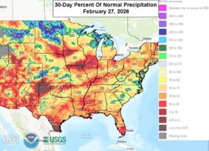
Kansas City, February 27 (World Weather Inc.) – Meteorological Spring begins March 1. Several of the main crop areas in the United States will begin spring under drought or abnormally dry conditions with some of the most severe dryness in the southeastern states, southern Plains, and portions of the Delta and central Midwest. A few locations in the northern Plains and Upper Midwest have some snow on the ground that will marginally improve the moisture profile once melted. March will be a very important month with much of crop country needing significant amounts of precipitation. An active weather pattern is in store for a large section of the U.S. east of the Rocky Mountains during the next two weeks, which should relieve drought and dryness in many areas; however, concerns for dryness in the Plains will likely persist for much of the month and may impact early-season planting in April.
South Texas, NE Mexico Dryness Exacerbated By Heatwave
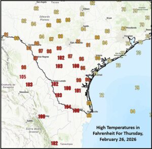
Kansas City, February 27 (World Weather Inc.) – Weather in North America has been nothing short of unusual this winter with wild gyrations in temperature and crazy bouts of snow and rain. The coming ten days will be no different. Thursday’s weather was quite impressive for late February with southern Texas and northeastern Mexico temperatures rising through the 90s Fahrenheit and over 100 degrees. The heatwave was quite impressive since this is supposed to be the winter season. The heatwave exacerbated a drought that has been prevailing this winter in southern Texas where spring planting normally begins in March. Soil conditions are not nearly wet enough to support dryland planting no relief is expected. The heatwave will be less impressive over the coming week, but daily highs in the 80s and some 90s will continue.