
Tropical Storm Norbert and Depression Fifteen-E Will Not Be a Direct Threat to Land
Tropical Storm Norbert is moving westward over the east-central Pacific and is expected to become a remnant low in the next couple of days. Rain associated with Norbert’s remnants may move into Hawaii later this week, so a close watch may still be needed on this system by those with interests in the Hawaiian Islands. Tropical Depression Fifteen-E will not be a threat to land in its lifetime, and the disturbance being monitored in the central Atlantic is unlikely to develop into a more organized system.
Brazil Coffee Weather For September 14, 2026
Kansas City, September 14 (World Weather, Inc.) – Ran fell from scattered showers and thunderstorms from northern Parana into Sul de Minas Friday through this morning. The precipitation was all welcome and good for crop development. The pattern will continue into next week, although much of the rain Tuesday through Thursday will be light and sporadic before increasing again at the end of this week. Temperatures should be seasonably warm.
South America and South Africa Weather Outlook Maps For September 14, 2026
Click Here to download two-week weather outlooks for South America and South Africa.
Updated 3-Day Precipitation and Temperature Maps For North and South America For September 14, 2026
Click on the link to see some of the most recently updated precipitation and temperature maps for North and South America. These are some of the more popular maps, but remember to look at our map gallery for a more complete listing of past weather maps for around the world.
Selected 3-Day Precipitation and Temperature Maps For September 14, 2026
Click on the link to see some of the most recently updated precipitation and temperature maps for North and South America. These are some of the more popular maps, but remember to look at our map gallery for a more complete listing of past weather maps for around the world.
Tropical Storm Edouard Unlikely To Have Much Impact
Kansas City, September 1 (World Weather Inc.) – Tropical Storm Edouard was expected to move across the upper Texas coast near the Louisiana border later today, but its impact is unlikely to be very great. Maximum sustained wind speeds were reaching 40 mph prior to dawn today and they may reach 65 mph prior to landfall, according to the U.S. National Hurricane Center, but the amount of rain and wind anticipated in eastern Texas and Louisiana may be less than what occurs from large thunderstorm clusters. Not much agriculture is in east Texas to be harmed and most of Louisiana’s rice and sugarcane are far removed from the storm’s greatest impact. Little to no damage to personal property, infrastructure or agriculture is anticipated, although a little coastal wind damage is possible and local flooding will follow the storm’s center into eastern Texas tonight into Thursday.
Typhoon Saudel Will Slam Into Southeastern China Later Today
Kansas City, August 27 (World Weather Inc.) – Typhoon Saudel brought damaging winds and torrential rain to Okinawa and neighboring areas in Japan’s Ryukyu Islands earlier this week. The disturbance is now heading for China with landfall over Zhejiang this evening. Saudel will bring heavy rain and strong winds to Fujian, Zhejiang, Jiangxi, and neighboring areas in southeastern China overnight tonight into this weekend before dissipating. Damage to the unharvested rice, sugarcane, and other crops is possible, in addition to impacting a few ports and other infrastructure. Harvesting and general fieldwork will likely be delayed for several days as well.
Predicted Showers In Brazil May Benefit Early Season Crops
Kansas City, August 26 (World Weather Inc.) – Very strong to “super” El Nino events of the past have tended to produce above normal precipitation in southern Brazil during the entire winter, spring and a part of the summer. This year’s winter weather has certainly been plenty wet in the south of Brazil and in neighboring areas of Uruguay, southern Paraguay and far eastern Argentina. Dryness has been significant in in center west and northern parts of center south Brazil as well as the northeastern states of Brazil, but that dryness is quite “normal” for winter. Market concerns about weather around the world are beginning to turn toward the approaching South America growing season and the dryness present in center west and northeastern Brazil. Recent computer forecast model runs have been suggesting that showers and weak thunderstorms may evolve next week and into mid-September to possibly support early season planting of corn, rice and soybeans. Sugarcane development may benefit from the moisture as will early season coffee flowering in at least parts of the production region.
China Will Be Impacted By Several Tropical Disturbances
Kansas City, August 24 (World Weather Inc.) – Tropical Storm Narra and another disorganized tropical disturbance were noted just south of China this morning. These disturbances will promote bouts of significant rain for Guangxi, Yunnan, Fujian, and immediate neighboring areas through mid-week before dissipating. Localized flooding will be a concern and may damage a minor amount of rice, sugarcane, and other crops produced in these locations. Overall production impacts should be minimal. In the meantime, Typhoon Saudel continued tracking over the western Pacific Ocean over the weekend. This disturbance will impact Japan’s central Ryukyu Islands Tuesday before reaching the East China Sea later this week. Saudel could clip northern Taiwan Thursday before entering southern China Friday and Saturday. The threat for flooding will remain high in southern China barring a significant change to the track Typhoon Saudel will take.
Tropical Storm Narra Brings Torrential Rain to Vietnam, China
Kansas City, August 23 (World Weather Inc.) – Tropical Storm Narra brought torrential rain to a part of northeastern Vietnam and southwestern China during the weekend. The system was expected to remain over the Gulf of Tonkin until around 2100 UTC Tuesday at which time it will more definitively move into Guangxi, China. The storm promises two more days of rain in these areas and there is some potential that after the system dissipates in China Tuesday its remnants may drift back into northern Vietnam. Additional excessive rain and flooding will raise the potential for some landslides and negative impacts for rice, coffee and sugarcane grown in the region.
West-Central Africa Crops Mostly In Good Shape…For Now
Kansas City, August 20 (World Weather, Inc.) – Despite strong El Nino conditions, adequate rain has fallen recently to support coffee, cocoa, rice, sugarcane, and cotton produced in west-central Africa. These crops are suspected of being well-rated and have good production potentials, but that may change if the influence of El Nino increases in the coming months and Harmattan winds (typically occurring from November into February) were to become more intense than usual. Rain during the next few weeks will be critical in boosting soil moisture if El Nino’s influence increases and seasonal rains were to diminish earlier than usual in September. Most crop areas should receive enough rain through the next two weeks to maintain favorable crop conditions, but not all areas will receive enough rain to induce significant increases in soil moisture.
Indonesia Dryness Remains; Malaysia Crops Still Favorable
Kansas City, August 10 (World Weather Inc.) – Rain in the first ten days of August was limited in central and southern Kalimantan, southern Sumatra, Java, Sulawesi and the Lesser Sunda Islands of Indonesia while rain fell more significantly to the north. The lack of rain in these central and southern Indonesia locations has led to short and very short soil moisture and some warmer than usual temperatures which is stressing many short-rooted crops. West-central and northern Sumatra and most of Malaysia have continued to receive timely rain so far this month preserving favorable crop conditions. Some areas in New Guinea have also reported well below normal rainfall. Drier-than-usual weather will prevail for at least another week. Malaysia, northern Sumatra, and neighboring areas in Kalimantan will still see spotty rain while areas farther south receive little to no precipitation. Dryness will intensify and may continue to promote less than favorable development.
Southern Indonesia Dryness Intensifying
Kansas City, July 13 (World Weather Inc.) – A large section of Indonesia outside northern and central Sumatra and pockets in northern Kalimantan were drier or even much drier than usual during the past month. The ground gradually firmed and many locations are too dry to support favorable rice, sugarcane, corn, and other short-rooted crop development. Precipitation will remain limited for Java, the Lesser Sunda Islands, southern Sumatra, portions of Sulawesi and southern Kalimantan for at least another week and additional drying is expected. Moisture stress may impact production potentials if precipitation remains limited through the end of the month. Other areas in Indonesia will see a good mix of rain and sunshine. Short-term development conditions will remain relatively favorable outside the driest areas in Sulawesi.
Typhoon Bavi To Steadily Weaken Upon Approach to China
Kansas City, July 9 (World Weather Inc.) – Typhoon Bavi was trekking through the Philippine Sea today while experiencing some dry air intrusion. The storm was expected to steadily weaken the remainder of today and Friday as it steams toward southeastern China. Landfall is expected Saturday, but the storm will already be impacting Taiwan Friday with bands of rain and increasing wind speeds. The storm will reach Zhejiang, China around 1500 UTC Saturday, July 11 as a Category One hurricane equivalent storm. Flooding is the greatest risk from this system for rice in particular, but some other grain, oilseed, citrus and sugarcane areas will be impacted to some degree as well.
Mexico Crop Conditions Relatively Favorable
Kansas City, July 8 (World Weather Inc.) – Rainfall earlier this year and timely monsoonal rain since the beginning of June was noted for a large section of Mexico. Planting, establishment, and development conditions have been relatively good for the nation’s summer crops; like corn, soybeans, dry beans, sugarcane, cotton, rice and coffee, among others. A few locations in the north and southeast dried down recently and would welcome a boost in rain this month. Much of Mexico will see a good mix of monsoonal rain and sunshine through at least the middle of next week. Portions of northeastern, north-central, and extreme southeastern Mexico will dry down despite some spotty rain and the need for rain will increase later in July. Other locations will receive enough rain to maintain aggressive growth.
Indonesia, Malaysia Rainfall To Increase Once Again
Kansas City, June 9 (World Weather Inc.) – Much of Southeast Asia has experienced erratic rainfall recently with some areas in Indonesia seeing notable drying. Timely rain will become increasingly more important as El Nino continues to intensify. Many areas in Indonesia and Malaysia in particular experienced uneven rainfall in recent weeks in part due to the Madden-Julian Oscillation. Unusually light and sporadic rain has been impacting Sumatra and Java in the past ten days along with portions of Sulawesi while greater rain occurred to the north and east. A change in weather is slated for the coming ten days that will support a return of more abundant rain. Relief from recent drying in Java, Sumatra and Sulawesi is expected and that is very important with El Nino coming on strong soon. El Nino will eventually win out and induce a more extended period of drier than usual weather raising concern for all crops in Southeast Asia.
Tropical Storm Jangmi Intensifies Over Philippine Sea
Kansas City, May 29 (World Weather Inc.) – Tropical Storm Jangmi continues to intensify over the open Philippine Sea. At 1500 UTC, maximum sustained winds were at 50 mph and moving west-northwest at 14 mph. Jangmi is currently expected to peak with wind speeds near 90 mph this weekend over the open ocean, making it equivalent to a strong category 1 hurricane on the Saffir-Simpson scale. The storm will impact the Ryukyu Islands with maximum sustained wind speeds between 70 and 85 mph. Heavy rainfall, a storm surge, and high wind speeds will accompany the storm. Jangmi will gradually weaken over the course of next week, but will graze the southern coasts of Kyushu, Shikoku, and Honshu, bringing adverse conditions as well. A close watch on Jangmi will be needed for any changes in the projected track and for those with interests in Japan.
South America, South Africa, and Europe Weather Outlook Maps For March 2, 2026
Click Here to download two-week weather outlooks for South America, South Africa, and Europe.
Brazil Coffee Weather For March 2, 2026
Kansas City, March 2 (World Weather, Inc.) – Rain concentrated on areas north of Sul de Minas during the weekend and the precipitation is expected to become more erratic during the coming week. Tuesday and Wednesday may be the driest days while precipitation late this week into early next week will be greatest from northeastern Sao Paulo into Sul de Minas. Temperatures will trend a little warmer this week especially while rainfall is lightest and most sporadic.
South America Weekend Cold Has Low Impact on Agriculture
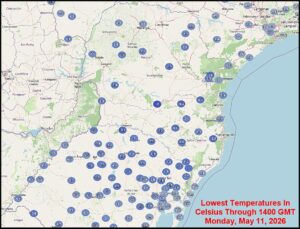
Kansas City, May 11 (World Weather Inc.) – Cold temperatures in Argentina, Uruguay, Paraguay and southern Brazil during the weekend and early today had a variety of influence on agriculture, but none were so great to seriously impact production. Frost and freezes ended the growing season in some areas of Argentina where such conditions had not yet occurred this year. Frost and freezes in Brazil occurred outside of key summer crop areas leaving Safrinha corn unaffected and wheat was not far enough advanced to be negatively impacted. Coffee, citrus and sugarcane were also far enough to the north in Brazil to miss any potential for a negative impact on production.
Queensland, Australia Floods From Tropical Deluge
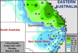
Kansas City, March 9 (World Weather Inc.) – Computer forecast models predicted an excessive rain event for eastern Queensland most of last week and it finally arrived during the weekend producing copious amounts of rain in a relatively short period of time. Flooding impacted many agricultural areas especially from east-central through southeastern parts of the state. Cotton may have been more adversely impacted than other crops. Other areas in eastern Australia also received some rain during the weekend; though no flooding resulted.
Eastern Queensland May See Flooding Due To Tropical System
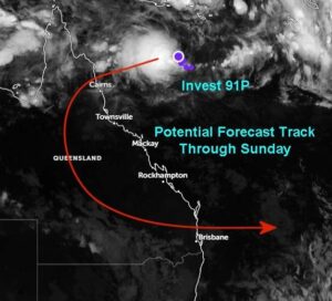
Kansas City, March 3 (World Weather Inc.) – Several tropical disturbances were noted just to the north of Australia this morning. While these disturbances are not expected to become significantly strong tropical events, one disturbance east of Queensland, Australia will bring significant rain to several areas in Queensland later this week and weekend. Flood potentials will increase as rain lashes northern and eastern Queensland, which could damage sugarcane and other crops grown in the region. Rainfall in southeastern Queensland could also impact cotton quality and harvesting.
Florida Freezes, Strong U.S. Heating Demand Into Next Week
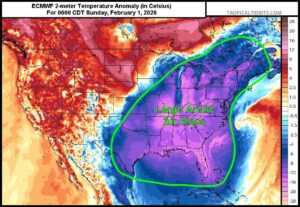
Kansas City, Jan. 28 (World Weather Inc.) – A reinforcing surge of arctic air is developing and will be moving south from Canada later this week. With so much snow and sleet coverage present across the Midwest, northern Delta, Kansas, and Oklahoma, the cold air mass will not be able to moderate quite as much as it would otherwise when it moves south. This will help lead to significant cold anomalies across the southern U.S. again late Friday into Tuesday. Hard freezes are expected down into southern Texas, the Gulf of America coast and down into interior southern Florida. Crops at risk of more damage include sugarcane and citrus. Temperatures in Florida are likely to be the coldest of the season so far and heating fuel demand will remain very strong through early next week. Eastern parts of North America may see additional cold later in February; though, this weekend’s outbreak will be most intense.
Freezes Impact South Texas, Louisiana Citrus And Sugarcane
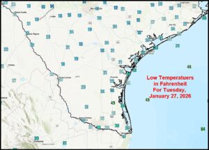
Kansas City, January 27 (World Weather Inc.) – Frost and freezes reached into northeastern Mexico, southern Texas and along most of the Louisiana and Florida Panhandle coasts this morning as a great culmination to the past several days of unusually intense winter weather in the central and eastern United States. Damage to citrus and sugarcane was suspected in both Texas and Louisiana, although the impact should not be tremendous unless poor weather occurs during the spring and summer.
Florida Citrus Farmers Watch Approaching Cold; Frost Likely
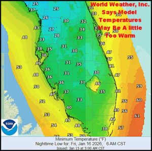
Kansas City, January 15 (World Weather Inc.) – Another unusually cold surge of air is moving through the southeastern United States today and it is expected to bring frost and a few freezes to the Gulf of America coast for at least the fourth time since October on Friday. The cold should not be deep enough to induce serious damage to citrus or sugarcane in the southeastern United States; although it will warrant spray irrigation and some mobile heating units overnight to ensure adequate crop protection especially in northern parts of the citrus belt. Monday may be coolest.
Some SE U.S. Sugarcane, Citrus To See Frost, Brief Freezes
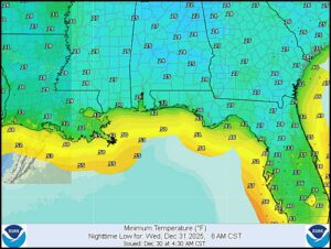
Kansas City, December 30 (World Weather Inc.) – Frost and freeze conditions are likely to impact sugarcane areas of Louisiana and minor citrus production areas of northern Florida Wednesday morning for the third time since October. The impact of cold conditions has been relatively low in past events and the same is expected Wednesday. Temperatures will not be cold enough to induce any permanent damage in sugarcane areas, but some citrus groves in northern Florida will need the assistance of irrigation systems to provide some protection to unharvested fruit and flower buds for the coming season. Other fruit trees in the southeastern United States have been impacted by widely swinging temperatures in recent weeks and this trend will continue into late winter.
Southeast Asia To Deal With Waves Of Rain, Flooding Again
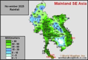
Kansas City, December 11 (World Weather Inc.) – A welcome respite from flooding rain has occurred recently in portions of Southeast Asia allowing flood water to recede and at least some clean up to take place after some horrific flooding in November and previous bouts of flooding dating back into September. Severe flooding impacted parts of Vietnam, the Philippines, Thailand, Indonesia and Malaysia at one time or another since mid-September. A new period of unsettled weather is about to begin once again bringing back the risk of flood damage to the Philippines and portions of Indonesia and Malaysia. Some significant rain will also impact parts of central Vietnam and areas near the east coast of the Malay Peninsula in Thailand during the next couple of weeks. Concern will return over the potential for flood damage to crops and personal property during this period of time.
Tropical Depression Koto Will Bring Rain To Vietnam
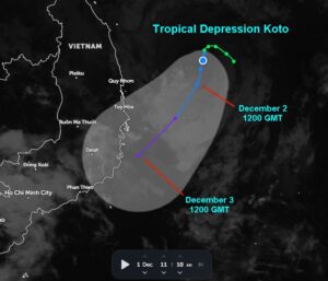
Kansas City, December 2 (World Weather Inc.) – Tropical Depression Koto slowly meandered around the South China Sea over the weekend. After briefly intensifying to a typhoon, conditions have been unfavorable for continued development. The system was recently downgraded to tropical depression and will further weaken in the coming days. Remnants of Koto will still help generate rain for portions of Vietnam and Cambodia through Thursday. Crop and structural impacts should be minimal due to the rain.
Flooding Expected in Sri Lanka Rest of Week
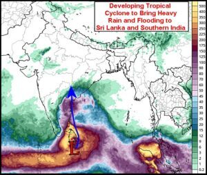
Kansas City, November 24 (World Weather Inc.) – Not to be left out of all the flooding that has been impacting Southeast Asia recently, Sri Lanka will also be impacted by such conditions. A tropical disturbance that is organizing into a tropical cyclone near the island nation today is expected to influence the region for the balance of this week. Waves of rain are expected along with gusty surface wind resulting in some flooding. Crop and property damage is predicted, although the impact should be low. The storm will ultimately end up in southern India where some other heavy rain is predicted.
Brazil Enters New Period of Drying After Erratic Weekend Rain
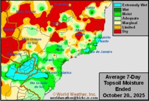
Kansas City, October 21 (World Weather Inc.) – As reported Friday, the Amazon River Basin continues to show much less convective activity than that which usually occurs in the second half of October. A change toward more stormy weather must occur to restore water supply in that basin, but also to feed moisture into center west and center south Brazil in support of soybeans, corn, rice, coffee, citrus, sugarcane, dry beans and other crops. Weekend rainfall coverage was probably the best seen in quite a while; however, rain amounts were disappointing in many areas. A full week of drier weather is now expected in center west and northern center south crop areas and that should translate into quick drying and additional stress for recently emerged crops that failed to get much rain. The drier bias will also slow additional planting, although at this point in time producers are likely to plant in the dust knowing that rain is sure to come soon.
Brazil Monsoon Pattern Slow To Evolve; Amazon Basin Dry
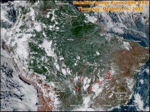
Kansas City, October 16 (World Weather Inc.) – Satellite imagery from South America shows a general lack of cloudiness and convection across the Amazon River Basin – an extremely important moisture source for Brazil’s center west and center south agricultural region during the October through April period. Mid-latitude cool fronts have been responsible for most of the rain seen in these crop areas in recent weeks and another frontal system is due into the region this weekend. Concern is rising, though, that rainfall associated with the frontal system may be a little disappointing due to the lack of monsoon or pre-monsoon moisture over the Amazon Basin. There are some signs of improving moisture for the Amazon Basin and center west and center south Brazil, but the best rainfall may hold off until early November.
Typhoon Tapah Reaches Western Guangdong, China
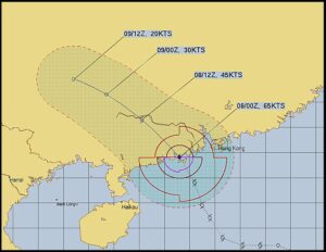
Kansas City, September 8 (World Weather Inc.) – Typhoon Tapah moved inland over western Guangdong, China late Sunday and early today. The storm came ashore as a weak typhoon and will quickly weaken during the day and dissipate Tuesday. Torrential rain and strong wind speeds accompanied the storm inland and it will continue to produce those features through mid-day today before beginning to diminish. Some damage to crops and property is anticipated.
Thailand Drying Unlikely To Have Big Impact
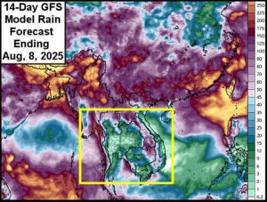
Kansas City, July 28 (World Weather Inc.) – Thailand weather this year has been much better than that of 2024 even though there is a small area in central parts of the nation that has become a little dry. Weather in the next ten days will not only keep the same region drier than usual, but there will be some expansion in the dryness to include a much larger part of rice, sugarcane and corn areas. The dryness may last ten days to two weeks at which time it will be very important that seasonal rains resume to ensure there is no negative impact on production for rain fed crops. Indonesia and Malaysia rainfall should improve this week while Cambodia and Vietnam will continue drier than usual.
Tropical Storm Wipha To Bring Flooding To South China
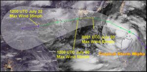
Kansas City, July 18 (World Weather Inc.) – Tropical Storm Wipha formed near the north coast of Luzon Island, Philippines today and was expected to strengthen while moving toward Guangdong China this weekend. The storm will then turn to the west and bring flooding rain to western Guangdong, southern Guangxi and portions of both northern Hainan and northern Vietnam. Landfall in northern Vietnam is expected early next week. In the meantime, flooding rain is expected today and Saturday in the northwest half of Luzon Island.
Depression Danas To Contribute To South China Flooding
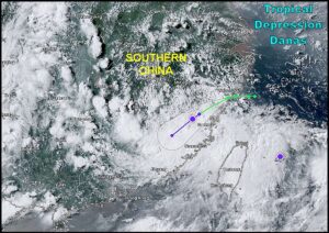
Kansas City, July 9 (World Weather Inc.) – Tropical Storm Danas moved into Fujian, China overnight and diminished to depression status. The storm and its remnants will drift through southern China over the next few days contributing to a rainy pattern that may help induce a little flooding. Damage from the storm in China was suspected of being much less than the impact on crops reported from Taiwan earlier this week. Danas is just the first of several tropical cyclones that are predicted to evolve and impact Southeast Asia over the next two to three weeks.
China’s Driest Region May Shrink A Bit; Hotter Next Week
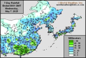
Kansas City, May 7 (World Weather Inc.) – Drought conditions expanded a bit during this past week in China’s east-central crop areas; including parts of the Yellow River Basin and North China Plain. Some of the expansion occurred because of hot temperatures last weekend that sent extreme readings to 104 Fahrenheit; however, cooling has since occurred bringing a little relief, although without rain the dryness will remain a concern. Weather in the next week to ten days will bring some important rain to a part of Hebei, Shandong and Liaoning which may reduce the overall size of the most seriously impacted drought region. However, dryness in the Yellow River Basin will prevail and another round of excessive heat is due into the region next week. In the meantime, rain will continue falling frequently and abundantly in southern China where crop conditions are rated favorably.
Brazil April Weather Suggests Near To Below Normal Rain
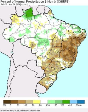
Kansas City, April 2 (World Weather Inc.) – Brazil rainfall has not been as abundant or significant as it usually is near the end of the monsoon season especially in center south and northeastern parts of the nation. However, timely rain has continued to support crops and this process will continue for the next two weeks. There is concern that the monsoon season will end later this month without the ground being totally saturated and that may lead to moisture shortages when the late planted Safrinha corn reproduces and fills. Some of this was expected and the commodity trade has already factored this potential into futures prices, but the situation needs to be closely monitored for signs of hotter than expected weather during the dry season. World Weather, Inc. would not be surprised to see a few scattered showers and thunderstorms during the dry season to slow the rate of drying in “some” Safrinha crop areas.
China’s Crop Region In Growing Need Of Rain
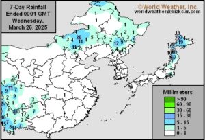
Kansas City, March 26 (World Weather Inc.) – Precipitation was limited for a large section of China’s main agricultural production areas during the past week leading to some net drying for most areas. The Yangtze River Basin still had enough moisture to support new winter rapeseed growth while the North China Plain became a little more notably dry. Moisture shortages are also ongoing in southern China, where early rice and corn are being planted while sugarcane development increases. Additional drying over the next week to ten days north of the Yangtze River will further deplete soil moisture and could lead to greater crop stress later in April if rain does not evolve soon. Areas near and south of the Yangtze River will see a good mix of rain and sunshine through the middle of next week that will help ease some of the dryness, although Yunnan and bordering areas will remain dry.
Southern China Rain Will Improve Soil Moisture; More Needed
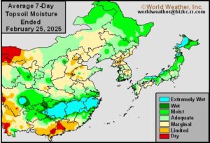
Kansas City, February 27 (World Weather Inc.) – Southern China saw some spotty rain during the past week with more significant rain on the way in the coming days. The rain will help improve the moisture profile just in time as early-season rice, corn, and sugarcane planting normally begins late February or early March. Rainfall will be too light to completely fix the moisture deficits and additional precipitation will be needed later in March. The Yangtze River Basin, North China Plain, and central Yellow River Basin will also see a good mix of precipitation and dry weather during the coming week. Precipitation totals will be enough to maintain a good outlook for the winter rapeseed and wheat. Some of the rapeseed may come out of dormancy, though temperatures will not be warm enough to promote growth across the main winter grain and oilseed production areas.
Center-South, Northeastern Brazil Dryness Threatens Crops
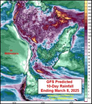
Kansas City, February 25 (World Weather Inc.) – Brazil soybean and first-season corn harvesting remains a little behind last year’s pace despite significant gains in the past week. Rainfall varied significantly across the main production areas with many areas in the far south and northeast receiving little or no rain. In addition to the lag in soybean harvesting, Safrinha corn planting remains a little behind last year’s pace as well. While the lack of rain was welcome to support more aggressive harvesting, several fields that missed out on rain in recent weeks are in growing need of moisture. A large section of Brazil will trend drier than usual during the coming week, though Mato Grosso and neighboring locations will receive enough rain to maintain relatively good Safrinha corn development prospects while slowing fieldwork periodically. Heat and dryness may also have a negative impact on coffee and sugarcane production.
Sao Paulo Rainfall Next Few Days To Improve Sugarcane
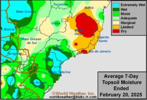
Kansas City, February 20 (World Weather Inc.) – Showers and thunderstorms are expected in portions of center south Brazil over the next several days. The moisture will be extremely important for sugarcane as well as for some corn, soybean, citrus and coffee areas after recent drying. Sufficient amounts of rain are expected to maintain or improve topsoil moisture for crops in this region.
Mato Grosso Soybean Harvest May Remain Sluggish
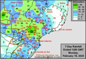
Kansas City, February 10 (World Weather Inc.) – Brazil’s soybean harvest is behind last year’s pace in part due to wet weather in some of the main production areas in recent weeks. As a result, safrinha corn planting is behind last year’s pace as well. With drier weather slated for several areas from center-south and northeastern Brazil into Mato Grosso do Sul this week, the harvest pace, along with safrinha corn planting progress, may advance more swiftly. Mato Grosso and portions of southern Brazil will see more frequent rainfall this week that may continue to promote sluggish harvesting and safrinha corn planting. In the meantime, some of the main sugarcane, citrus, and coffee areas will dry down this week due to the lack of abundant rain. As long as timely rain returns later this month, no major production impacts are expected.
Louisiana Sugarcane, Much of South U.S. Cold Damaged
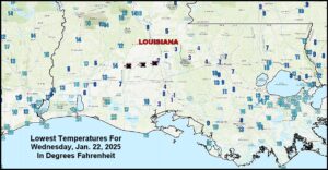
Kansas City, January 22 (World Weather Inc.) – Incredibly cold temperatures occurred this morning in the Deep South of the United States as well as northeastern Mexico. Hard freezes occurred as far south as southern Texas, northeastern Mexico and the entire central U.S. Gulf of Mexico coast causing damage to crops and property. The most damaging conditions were noted in fruit and vegetable areas of southern Texas, northeastern Mexico and in portions of southern Georgia and northern Florida. Sugarcane areas in southern Louisiana experienced the coldest temperatures on record with readings in the single digits Fahrenheit and a couple of extremes near and lightly below zero.
Frost, Freezes In South Texas, NE Mexico Tonight
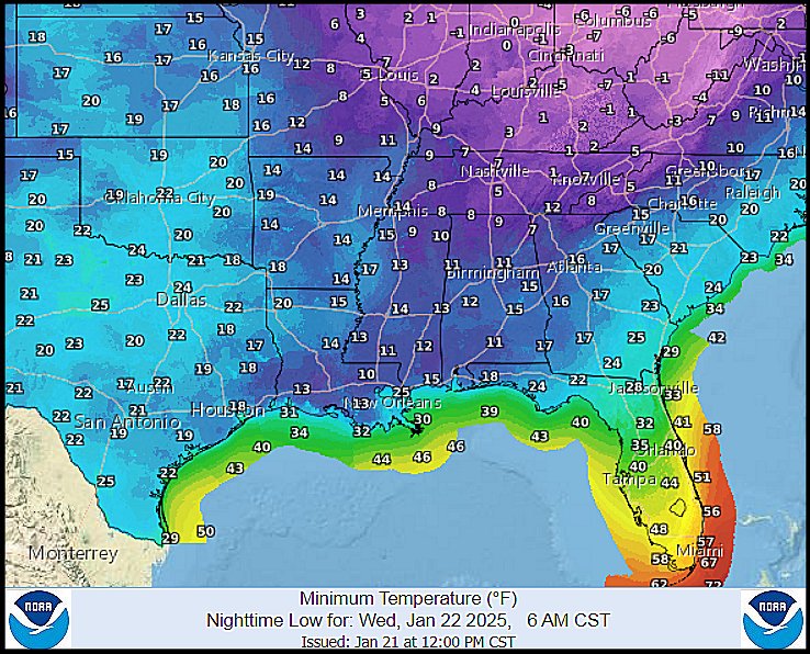
Kansas City, January 21 (World Weather Inc.) – Frost and freeze conditions have already been noted southward into interior southern Texas and along the entire central U.S. Gulf of Mexico coast this morning. The same areas will be impacted again tonight with the cold digging farther to the south through all of South Texas and into northeastern Mexico. An impact on fruit and vegetable crops is expected with some production cut possible for a few crops. Most of the damage to fruit trees and sugarcane is not expected to be very great, but some impacted is expected.
U.S. Bitter Cold To Threaten Sugarcane, Southern Wheat
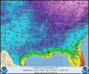
Kansas City, January 20 – (World Weather Inc.) – Bitter cold temperatures occurred during the long U.S. holiday weekend, although the impact on wheat was minimal – at least so far. The coldest temperatures are still forthcoming over the next few nights and there may be some negative impact on lower Midwest, Delta and Tennessee River Basin production areas. However, damage to sugarcane in Louisiana may be more significant.
U.S. Bracing For Blast Of Arctic Air Through Early Next Week
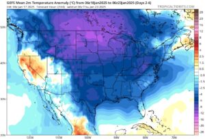
Kansas City, January 17 (World Weather Inc.) – A pool of warmer air spread across portions of North America in recent days, though the warmer period will quickly come to an end this weekend as a blast of arctic air surges southward across much of North America east of the Rockies. Temperatures will plummet well below normal for this time of year, increasing energy demands and potentially stressing livestock. Pockets in Nebraska, Iowa, and neighboring locations will also experience sub-zero degree Fahrenheit readings Monday morning while also having little to no snow on the ground. Winterkill will be a concern and may damage a minor amount of wheat and other crops produced this time of year. Freezes will reach as far south as northern Florida, southern Louisiana and southern Texas, though the coldest air should remain outside the main citrus areas of Florida. Arctic air will shift into eastern North America toward the middle of next week, keeping temperatures below normal across the region, but the last days in January will be warmer.
North America Arctic Air Outbreak To Have Many Impacts
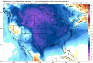
Kansas City, January 14 (World Weather Inc.) – Although an upper-level trough will make its way across eastern North America during the next few days, temperatures will only trend a few degrees cooler than usual for portions of the U.S. and Canada. Warmer air associated with a nearby high-pressure ridge will otherwise spread across a large section of North America later this week, prompting above or well above normal temperatures for several locations. This period of warmer weather will be short-lived as a pool of arctic air is slated to expand across North America this weekend and next week. Areas near and east of the Rockies will gradually see temperatures drop below to well below normal during this time with exceptions for southern Florida, Maine, and eastern fringes of Canada. The cold weather will increase energy demands and may stress livestock. Winterkill will also be a concern in pockets of the northern Plains and Nebraska due to little snowpack and a lack of new snow before the coldest weather.
SE U.S. Cold Should Spare Sugarcane, Citrus From Serious Harm
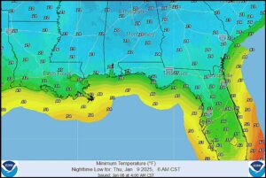
Kansas City, January 8 (World Weather Inc.) – A series of cold air masses continue to pass through the southeastern one third of the United States keeping the region near and south of the Ohio River Valley colder than usual. A winter storm passing through the Delta to the middle and southern Atlantic Coast States Thursday into Saturday will reinforce this trend and maintain some very cold weather in the Gulf of Mexico Coast States. Frost and a few light freezes will occur in Louisiana sugarcane and some northern Florida citrus areas, but the intensity of the cold should stop short of causing a serious threat to 2025 production. Other crops in northern Florida and the southeastern states will be impacted by the cold, although recovery is expected without much concern over future development.
Brazil Weather Outlook Shows Little Change For A While
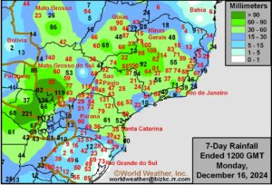
Kansas City, December 16 (World Weather Inc.) – Brazil continued to receive enough rain to support a good environment for soybeans, sugarcane, citrus, coffee, first-season corn, dry beans and other crops produced this time of year. Fieldwork and crop development are moving along swiftly, despite frequent precipitation and the outlook calls for more of the same through the next two weeks. Production potentials are still looking good for most crops, although citrus greening will likely hold back production for those crops.
Peninsular Malaysia, Java Expecting Heavy Rain; Flooding Likely
This content is for members only
Brazil Weather To Stay Quite Favorable
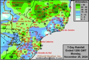
Kansas City, November 25 (World Weather Inc.) – Nearly ideal weather since late October has fieldwork and crop development in Brazil advancing quite favorably and the trend will continue, despite some recent drying in the interior south. The benefit does not stop at grain and oilseed production areas, but reaches into coffee, citrus, sugarcane and rice production areas as well. More of the same is expected over the next two weeks with timely rain anticipated for all production areas.
Panama, Costa Rica Will Trend Unusually Wet
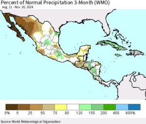
Kansas City, November 22 (World Weather Inc.) – Several locations in Central America were unusually wet in recent weeks. Tropical Storm Sara brought copious amounts of rain to portions of Honduras, Belize, and neighboring locations earlier this month that induced extreme flooding. Crop damage has not been fully assessed; however, the wet weather may have slowed harvesting and general farming activity. Panama and Costa Rica will remain unusually wet in coming weeks, which may further disrupt the harvest. These countries produce some rice, corn, sugarcane, coffee and a host of other tropical and subtropical crops during the Northern Hemisphere winter and the moisture will help support a good outlook. Areas farther north in Central America will be drier biased, which will be beneficial for the ongoing harvest.
Brazil Dryness To Be Confined to Southern Sao Paulo, Parana
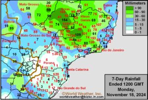
Kansas City, November 18 (World Weather Inc.) – Planting of the soybeans, first-season corn, and other crops advanced swiftly in much of Brazil during the past week. Conditions remained favorable for establishment and early-season growth as rain kept soil moisture at favorable levels. The main production areas will again have several opportunities for rain this week, though portions of Parana and Sao Paulo will trend drier than normal. Planting will continue despite periods of rain. Crop prospects will remain favorable despite many areas in Parana and Sao Paulo trending drier than normal. Winter wheat harvesting will also continue for southern Brazil, though some minor delays will be possible in the wettest locations of Rio Grande do Sul.
Hurricane Rafael To Move West Over Central Gulf Of Mexico
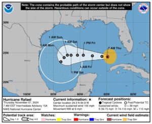
Kansas City, November 7 (World Weather Inc.) – Hurricane Rafael passed over western Cuba as a weak Category Three storm Wednesday. The system was over the southeastern Gulf of Mexico this morning and will move to the west over the next few days. The system may slowly weaken Friday into the weekend and a turn to the southwest is possible. The odds of this storm impacting U.S. crop areas seems to be diminishing, but it could bring some moisture and breezy conditions to the east coast of Mexico next week. The system needs to be closely monitored for possible changes, though.
Brazil Soybean, Corn Planting Will Persist Around Rain
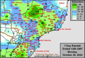
Kansas City, October 28 (World Weather Inc.) – Rain in center-west and south-central Brazil continued to improve the moisture profile during the past week. Soybean and first-season corn planting continued, though progress remains behind last year’s pace due to the late onset of seasonal rainfall. These areas will receive additional rain this week that will improve or maintain a good environment for crop establishment and early-season growth. Southern Brazil will trend drier than normal this week, which will be beneficial for more aggressive winter wheat maturation and harvesting while promoting additional summer crop planting.
Tropical Storm Trami To Impact Hainan, Vietnam
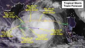
Kansas City, October 25 (World Weather Inc.) – Tropical storm Trami continued to move across the South China Sea today and will trek toward southern Hainan and central Vietnam by the end of the weekend. Model forecasts differ greatly over what happens to the storm eventually. World Weather, Inc. expects the system to weaken as it approaches Vietnam and much of its convection will be sheared off from the storm center and move into central Vietnam while the circulation center may remain off the coast for a few days.
Hurricane Oscar Impacting Eastern Cuba Coffee Areas
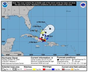
Kansas City, October 20 (World Weather Inc.) – Hurricane Oscar formed suddenly early in the weekend over open water in the Atlantic Ocean and was interacting with eastern Cuba today. The hurricane will be downgraded to tropical storm status later this evening as it moves briefly over land, but a turn to the north and then to the northeast will likely take the system to the southeastern Bahamas and then out to sea. The storm poses no threat to North America, but heavy rain and flooding is likely in eastern Cuba and southeastern parts of the Bahamas through Tuesday. Oscar will continue moving northeast during the middle and latter part of this week with the system slowly losing its tropical characteristics.
Hurricane Milton Leaves Florida; Damage Assessment Begins
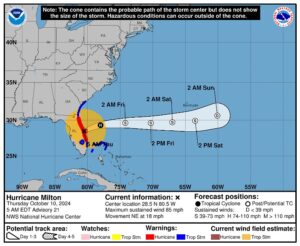
Kansas City, October 10 (World Weather Inc.) – Hurricane Milton left the coast of east-central Florida prior to dawn today and has left behind widespread power outages, considerable tree and structural damage and some significant flooding. The sun was just beginning to rise at the time of this report and visible damage assessments have not yet begun. However, the damage is suspected of being widespread from the heart of central Florida to interior portions of the northeast.
Taiwan Bracing For Torrential Rain From Typhoon Krathon
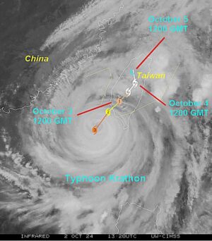
Kansas City, October 2 (World Weather Inc.) – Typhoon Krathon continued to meander slowly between Taiwan and Philippines during the past few days. Krathon will approach Taiwan today before advancing across the island overnight through early Friday. Torrential rain will spread across Taiwan today and Thursday with southern and eastern sections of the island receiving 10.00 to over 20.00 inches of rain. Severe flooding and landslides will likely promote significant rice and structural damage. Krathon will weaken while approaching Taiwan, but is still expected to make landfall as a typhoon. Once over Taiwan, the disturbance will weaken further and likely dissipate later in the day Friday.
Hurricane John Inducing, Flooding Rain In SW Mexico
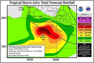
Kansas City, September 26 (World Weather Inc.) – Guerrero and Oaxaca, Mexico have already been impacted by Hurricane John as it started to meander along the southwestern Mexico coastline early this week. Flooding and landslides were already noted in portions of Guerrero while rain lashed several neighboring areas. Hurricane John will continue to meander along the southwestern Mexico coastline in the coming days, producing heavy rain in portions of Guerrero, Michoacan, Colima and Oaxaca. Several areas near the coasts will receive one to over two feet of rain (12-24 inches or 304-608mm) and severe flooding and landslides are expected. The torrential rain combined with damaging wind speeds will likely damage some citrus, sugarcane, sorghum and corn as well as other crops produced in the region. Remnants of John will continue to promote rain later this weekend and the first part of next week that will likely limit drying, damage assessments, and general farming activity.
Hurricane Helene’s Impact May Be Like That of Michael In 2018
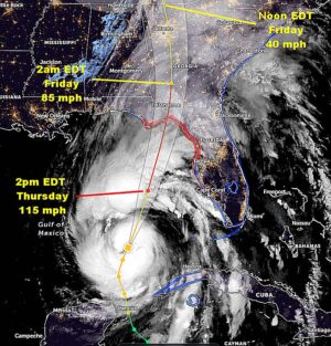
Kansas City, September 26 (World Weather Inc.) – Hurricane Helene will be barreling its way toward the southeastern United States today with landfall this evening in the northern Apalachee Bay south of Tallahassee, Florida. Landfall will occur as a Category Three storm with devastating impacts from the entire Apalachee Bay area northward into southern Georgia. Crop and property damage will likely be similar to that of Hurricane Michael that impacted much of the same region in early October 2018. Catastrophic damage will occur within 120 miles of the storm center, although the worst conditions will extend about 80 miles northeast of where the storm center reaches land.
Hurricane Francine Has Low Impact on Louisiana Crops
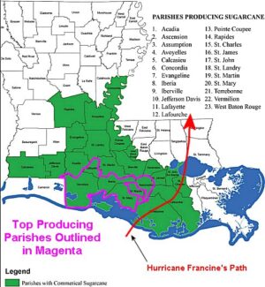
Kansas City, September 12 (World Weather Inc.) – Hurricane Francine moved through southeastern Louisiana overnight producing strong wind speeds and some heavy rain, but the storm’s path shifted just enough to reduce the percentage of prime sugarcane that was directly impacted by the storm. Some of the storm’s greatest rainfall and wind ended up occurring over a minor part of the sugarcane production region in southeastern Louisiana and then across the urban sprawl of the New Orleans metropolitan area. This left the most important sugar production areas in south-central Louisiana with more of a straight line wind that was strong enough to lay the crop down and minimize the potential for lodging. Conditions should be favorable in the coming weeks to get the crop standing upright well enough again to allow harvesting to advance relatively well.
WORLD SUGAR WEATHER: Brazil, Southern India Drying Out
Kansas City – September 12 (World Weather, Inc.) – Sugar production areas around the world are dealing with some moisture shortages that could cut into production during the coming year. Brazil soil moisture is quite limited, although the rainy season has not begun yet and there is plenty of time for improved rainfall. Southern and west-central India has recently begun to dry down and that, too, may have the market’s attention for a little while. Southern Indonesia is also experiencing some less than usual rain along with Ukraine and portions of Russia’s beet production area. Thailand has also had some stressful weather at times this year.
Hurricane Francine To Move Inland This Evening In Louisiana
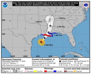
Kansas City, September 11 (World Weather Inc.) – Hurricane Francine was producing widespread rain along the Louisiana coast this morning, although the precipitation has been light so far. Wind speeds have also been light staying under 25 mph in most areas. However, the center of the storm was expected inland this evening passing to the south southwest of Morgan City. The storm center will pass to the west of New Orleans and it may come ashore with sustained wind speeds near or above 100 mph. Damage to sugarcane is quite likely along with serious beach erosion and both coastal flood and wind damage. The storm will then move up through the eastern Delta where some heavy rain and flooding is expected along with tropical storm force wind.
Typhoon Yagi Brings Flooding Rain In Northern Vietnam
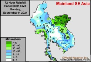
Kansas City, September 9 (World Weather Inc.) – Typhoon Yagi moved across Hainan, China Friday producing 145 mph sustained wind speeds and torrential rain. The storm then moved to northern Vietnam where landfall occurred with 100mph wind speeds along the coast. Damage occurred in both areas as well as in southwestern Guangdong (in the Leizhou Peninsula). Flooding rain also occurred across each of these areas and in southwestern Guangxi, China. Rain totals in northern Vietnam were most significant outside of Hainan with rain totals of 4.45 to 9.29 inches. A small region in northern Laos also reported torrential rain from the storm. Flooding was widespread and some damage to crops and property occurred in much of the region described above.
Super Typhoon Yagi Will Reach Southwest China Friday
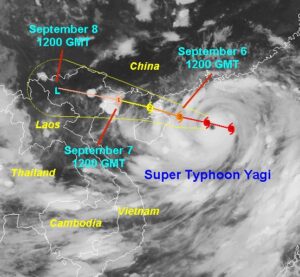
Kansas City, September 5 (World Weather Inc.) – Super Typhoon Yagi continued to intensify while tracking over the South China Sea in recent days. The storm has likely reached its peak of intensity and will begin to weaken as it moves toward southwestern China and northeastern Vietnam. Outer rain bands from the storm will reach eastern Hainan and southwestern Guangdong tonight. Torrential rain will then lash the southern halves of Guangxi and Yunnan, southwestern Guangdong, and northern Vietnam Friday and Saturday. The disturbance will rapidly weaken while tracking across southwestern China and northern Vietnam both days and will eventually dissipate by Sunday morning in northern Vietnam. Severe flooding and landslides are expected with many areas also experiencing damaging wind speeds as the disturbance makes landfall. Significant damage to crops and property is inevitable especially in southwestern China
West Africa Coffee, Cocoa Areas Will See Increased Rainfall
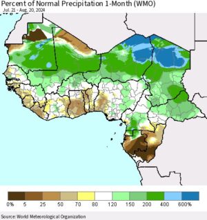
Kansas City, August 22 (World Weather Inc.) – Several production areas in west-central Africa were drier or much drier than normal during the past month. While August rainfall tends to trend a little lower compared to earlier in the summer and later in the autumn, the lower than usual rainfall has some producers concerned over a reduction in yield for some coffee, cocoa, sugarcane and rice produced in the region. More frequent rainfall is slated for the region during the coming week with timely rain expected to continue during the last few days of August and early September. The environment will slowly improve for late-season development of the early crops and for flowering of the mid-season crops.
Tropical Storm Debby To Flood Parts Of Georgia, The Carolinas
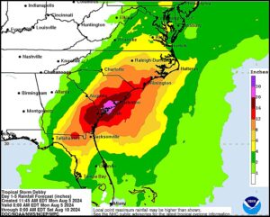
Kansas City, August 5 (World Weather Inc.) – Hurricane Debby already promoted heavy rainfall along the Gulf Coast of the Florida peninsula over the weekend. Flooding was noted in many areas as the disturbance approached the state and eventually made landfall over the Big Bend region of Apalachee Bay this morning. Debby has already been downgraded to tropical storm status and will track from northern Florida into Georgia today. The disturbance will meander around Georgia, move back over the western Atlantic Ocean briefly and then back into the U.S. southeast later this week with torrential rain slated for portions of Georgia, South Carolina, and eastern North Carolina. Severe flooding is the main concern with portions of southeastern Georgia and southern South Carolina potentially receiving more than a foot of rain. Property damage and damage to coarse grain, oilseed, cotton, and other crops is likely, especially those in low-lying areas.
Ivory Coast, Ghana Need More Rain For Good Coffee, Cocoa
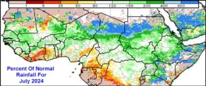
Kansas City, August 1 (World Weather Inc.) – Rainfall in July trended near to below normal in the main coffee, cocoa, rice and sugarcane production areas of western Africa. The region has adequate moisture to support most crops, although net drying has been accelerated in the past two weeks from Ivory Coast to Nigeria and Cameroon as seasonal rains shifted to the north. Cotton areas in Mali and Burkina Faso received near to above normal rainfall while areas to the south trended drier. . As long as periodic rain occurs in the next few weeks before seasonal rain returns, there should be no significant production changes. However, drier-than-normal weather is expected in coffee, cocoa, rice and sugarcane areas for at least the next seven days while rain falls frequently in cotton areas to the north. The need for rain in coffee and cocoa areas will increase later this month which is usually when seasonal rains normally return.
Tropical Storm Gaemi To Induce Flooding In Eastern China
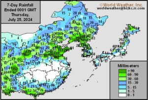
Kansas City, July 25 (World Weather Inc.) – After lashing Taiwan with torrential rain and severe winds, Typhoon Gaemi recently made landfall over Fujian in southeastern China. Gaemi has already moderated to a tropical storm and will continue to weaken while tracking over eastern China in the coming days. Heavy rain and strong wind will still evolve for Fujian and neighboring locations in Guangdong, Jiangxi, and Zhejiang into Friday. Remnants of Gaemi will also enhance rainfall for Shandong, Hebei, and northern Henan into Liaoning and Jilin later Friday into early next week. Flooding will be the greatest concern for these locations. Rice and sugarcane may be damaged in southeastern China. Grains, oilseeds, and cotton may also be impacted by flooding in portions of the North China Plain and Northeast China.
Thailand, Philippines In Need Of Abundant Rainfall
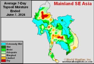
Kansas City, June 7 (World Weather Inc.) – A boost in seasonal rainfall has helped improve the moisture profile for much of mainland Southeast Asia in recent weeks. Pre-monsoonal rainfall in March, April and early May was well below normal and even though the region rain has been closer to normal there are lingering areas of low soil moisture. Some computer forecast model runs have recently suggested that parts of Interior southern Thailand, Cambodia and portions of Vietnam will be drier biased through the next two weeks after trending that way in this latest week. Many corn, rice, and sugarcane areas will either remain too dry or will become too dry to support ideal conditions and the need for abundant rain will remain high. In the meantime, some rain fell in the Philippines during the past week, though significant moisture deficits are ongoing in a large section of the country and timely rain through the end of next week will slowly improve the situation. Much more rain will be needed to completely fix the moisture deficits in the Philippines.
Additional Heavy Rain, More Flooding Coming To Southern China
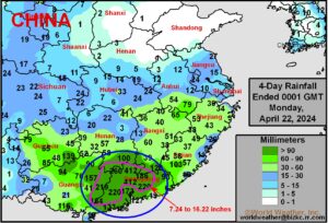
Kansas City, April 22 (World Weather Inc.) – Impressive rainfall has occurred in southern China, as predicted late last week. Rain totals were expected to range from 5.00 to 15.00 inches by the end of this coming week and amounts already reported through Monday morning reached up to 14.45 inches. Since Thursday morning some areas have already had more than 16.00 inches of rain and more is expected after a brief break today. Flood damage to crops and property has likely occurred, although not yet fully assessed and more damage is probably as the excessive rain resumes this week.
Philippines, Mainland Southeast Asia Rain Will Remain Limited
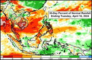
Kansas City, April 16 (World Weather Inc.) – Samar Island and neighboring areas of Luzon Island and Mindanao in the Philippines received rain during the past week. Most other locations in Philippines were dry or failed to receive enough rain to counter evaporation. Moisture deficits are ongoing and there will not be significant relief from dryness through the end of April. Planting and establishment conditions will remain less than favorable to poor for a large section of the country. Mainland Southeast Asia also received limited rainfall outside northern Laos, a few pockets in Thailand and southeastern Myanmar this past week. Drier-than-normal weather will persist for most locations outside pockets in northern and central Vietnam during the coming week. The need for rain will remain high in order to support more aggressive establishment and early-season growth.
South Africa Rain Too Late To Improve Corn
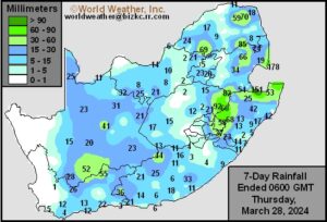
Kansas City, March 28 (World Weather Inc.) – Portions of western South Africa summer crop areas received enough moisture recently to induce a short term bout of improved late season crop growth. However, the relief came a little too late to seriously change production potentials especially for late season crops. The drier- and warmer-than- normal weather was due, in part, to El Nino. The environment gradually became too harsh for some of the late maturing coarse grains, oilseeds, cotton, and other crops produced in portions of Free State, North West, and Northern Cape. Yield potentials gradually decreased despite much of the country receiving varying amounts of rain during the past week. The country will see a mix of spotty rain and sunshine during the coming week. No significant fieldwork delays are expected. Rainfall will also be too light to significantly improve the moisture profile.
Central South Africa To Dry Down Further; Crop Losses Possible
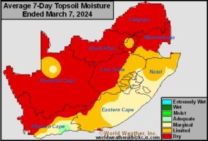
Kansas City, March 7 (World Weather Inc.) – A relatively warm and dry pattern continued to play out in central South Africa during the past week impacting western portions of the nation’s key summer agricultural region. Spotty rainfall did occur, though not enough to reverse the drying trend that began in February. Ongoing dryness continued to increase the risk for minor corn, oilseed, and other crop losses in Free State, North West, and neighboring areas. Many areas in eastern South Africa also dried down, but had enough moisture to maintain generally good development. Eastern South Africa will see a mix of spotty rain and sunshine during the coming week that will help maintain late-season growth. Western summer crop areas will miss out on much of the rain with temperatures remaining above normal.
Eastern Australia Will Continue To Dry Down; Stress Possible
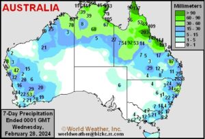
Kansas City, February 28 (World Weather Inc.) – Despite timely rainfall earlier in the growing season, eastern Australia has steadily dried down in recent weeks. Soil moisture has become too short to promote ideal late-season development. Timely rain would be welcome in the near future to support better growth as many crops finish developing and reproducing. The lack of rain was otherwise beneficial for the earlier planted coarse grains, oilseeds, cotton, and other crops that were maturing and getting ready for harvest. With the harvest normally beginning in March, a good mix of rain and sunshine will be needed to support good conditions for most crops. Eastern Australia will trend drier biased during the coming week, which will continue to promote less than favorable to poor late-season development. Maturation and early harvesting will otherwise advance swiftly. Production potentials will remain favorable for the summer crops despite recent dryness.
Queensland, Australia Crops To Benefit From Cyclone Kirrily
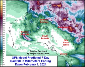
Kansas City, January 25 (World Weather Inc.) – Tropical Cyclone Kirrily made landfall over northeastern Queensland, Australia earlier today with some damaging wind speeds and heavy rainfall. Power outages were noted with some stressful conditions were suspected to livestock and sugarcane. The center of the disturbance will slowly meander across Queensland in coming days before eventually making its way into Northern Territory and potentially northern Western Australia later this weekend and next week. The storm’s convection, though, will spread across a large section of Queensland and northeastern New South Wales bringing welcome moisture to key sorghum, cotton and other important crop areas. Rainfall will significantly bolster soil moisture and may promote flash flooding in some of central Queensland’s agricultural region. Minor damage is expected away from the coast where landfall takes place while most of the impact will be beneficial and welcome with unirrigated crop benefiting most significantly.
West Africa Coffee, Cocoa Still Warm, But Missing Wind
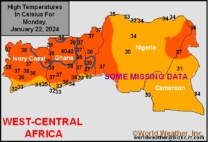
Kansas City, January 23 (World Weather Inc.) – Coffee and cocoa production areas as well as sugarcane, rice and other agricultural areas in West Africa have been enduring the dry season in recent weeks. Temperatures have trended warmer than usual, but the greatly feared Harmattan wind has remained at light speeds having a low impact on crop conditions. Most computer forecast models are suggesting similar conditions will prevail for the next two weeks.
Indonesia, Malaysia Expecting Frequent Rain In Coming Week
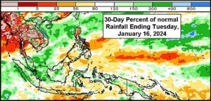
Kansas City, January 18 (World Weather Inc.) – A week of wet weather is in store for much of Indonesia and Malaysia. A Madden-Julian Oscillation event pushing through region and will help enhance rainfall for both countries during the next several days. Soil conditions will remain favorable for aggressive grain, oilseed, coffee, cocoa, rubber and tea growth and development. In the Philippines, many areas in Luzon Island continued to dry down in recent days. Western and northern Luzon will again see limited rainfall during the coming week that will keep the ground too dry for ideal crop conditions. Other locations in the Philippines have ample moisture for aggressive growth. A mix of spotty rain and sunshine is expected that may lead to a minor reduction in soil moisture for portions of Mindanao. Crop conditions will remain generally good in the Philippines with exceptions for the driest areas in Luzon.
U.S. Sugarcane Braces For Freeze: Florida Citrus To Be Spared
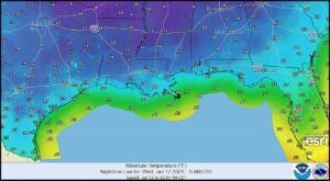
Kansas City, January 12 (World Weather Inc.) – This weekend’s deep arctic air surge into the central United States will eventually reach South Texas and the central Gulf of Mexico Coast States. Frost and freezes will impact most of Texas; including fruit and vegetable production areas in the south. Hard freezes are also expected to the Louisiana coast. Sugarcane in Louisiana is expected to be most significantly impacted by the cold, although some minor impacts on sugarcane and citrus will occur in South Texas and perhaps a few northern citrus production areas in Florida.