
Click Here To Download The Full Report
By Andrew Owen
A strong upper-level trough over central Canada will impact weather for southeastern Canada’s main production areas through the end of the weekend. Isolated snow flurries will evolve today most notably between the Great Lakes. A disturbance tracking around the trough will bring snow to much of the region Friday and Saturday with accumulations ranging from 5 to over 10 centimeters. High pressure will then build over the region and promote drier weather Sunday. The close proximity of the trough will promote colder than normal conditions for much of the region during this time. Daytime highs will struggle to climb more than a degree or two above freezing.
As the trough shifts further west over Canada next week, a stronger disturbance tracking around the trough will track into eastern Canada. This disturbance will initially promote light showers in pockets of southeastern Ontario Monday before more widespread precipitation evolves later next week. Precipitation will start out as rain before gradually changing over to snow or a wintry mixture. New snow accumulations will be light. Warmer air will seep into the Prairies these days, lifting temperatures closer to normal for this time of year.
The jet stream will become relatively active over North America during the second week of the outlook. As a result, temperatures will often fluctuate between cooler and warmer than normal for much of Southeast Canada. The jet stream will also bring disturbances near or into the region at times, which will produce varying amounts of rain. Some light snow accumulations cannot be completely ruled out, though much of the precipitation is expected to fall as rain.
Alternating Periods Of Precipitation, Sunshine Expected Into Next Week
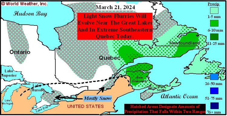
Light snow flurries will evolve through this afternoon for portions of the Great Lakes region and extreme southeastern Quebec as a disturbance passes near Southeast Canada. Resulting snowfall will only range from a dusting to 1 centimeter with coverage of 25%. The remaining production areas will be mostly dry today. Winds will be out of the west-northwest with speeds often ranging from 20 to 35 kph and gusts of 50 kph or higher. However, wind speeds will decrease in the Great Lakes region later in the day.
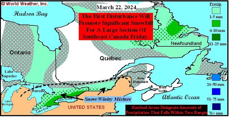
A disturbance tracking around the trough will enter eastern North America Friday. Precipitation associated with the disturbance will gradually expand from the Great Lakes region in the morning and early afternoon into extreme southeastern Ontario and southern Quebec later in the day. Moisture totals will range from 1 to 10 millimeters with locally greater amounts near Lake Erie and Lake Huron. Coverage will be near 100%. Precipitation will generally occur as snow, though areas near Lake Erie and Lake Ontario may see a wintry mixture of precipitation in the afternoon hours. Snowfall will range from 4 to 12 centimeters with locally greater amounts in Ontario.
East-southeasterly winds will evolve in southeastern Ontario in the morning and afternoon before turning to the east-northeast in the evening Friday. Southern Quebec will see west-northwesterly winds in the morning and afternoon and eventually east-northeasterly winds in the evening. Wind speeds will often range from 15 to 30 kph and gusts of 45 kph or higher.
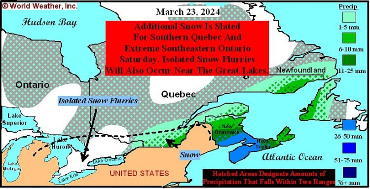
The disturbance will track further to the northeast across eastern North America Saturday. Snow will continue for southern Quebec and extreme southeastern Ontario in the morning and afternoon with some light snow flurries continuing in the evening and overnight hours. Moisture totals will range from 3 to 10 millimeters in southern Quebec with coverage over 90%. Snowfall will range from 5 to 15 centimeters in the main production areas. Extreme southeastern Ontario will receive a trace to 5 millimeters of moisture with coverage of 60%. Snowfall will range from a dusting to 5 centimeters. Isolated snow flurries will be possible in the Great Lakes region as well. Resulting snowfall will not be much more than a dusting with coverage of 10%. The Great Lakes region will otherwise be dry outside the pockets that receive minimal snowfall. Winds will shift from the east-northeast to the north-northwest across the region over the course of the day. Wind speeds will range from 15 to 30 kph and gusts of 45 kph or higher.
High pressure will advance into Quebec Sunday. The area of high pressure will help promote mostly dry weather for Southeast Canada for much of the day. East-southeasterly winds will gradually spread across southeastern Ontario while north-northwesterly winds are most common in southern Quebec. Wind speeds will range from 10 to 25 kph and gusts of 35 kph or higher, though slightly stronger winds will occur in the Great Lakes region in the evening hours.
As warmer air seeps into the region Monday, a disturbance will track into the U.S. Upper Midwest. This disturbance could generate light rain near Lake Huron in the evening and overnight hours with moisture totals ranging from a trace to 3 millimeters. Coverage will be 30%. The remaining production areas in Southeast Canada will remain dry. East-southeasterly winds are slated for southeastern Ontario with speeds often ranging from 20 to 35 kph and gusts of 50 kph or higher. Winds will be out of the east-northeast in southern Quebec with speeds ranging from 15 to 30 kph and gusts of 45 kph or higher.
Another disturbance will approach Southeast Canada Tuesday. Rain will gradually spread across southeastern Ontario over the course of the day. Moisture totals will range from a trace to 8 millimeters and locally greater amounts. Coverage will be 80%. Southern Quebec will receive little to no precipitation. Breezy south-southeasterly winds will spread across the region over the course of the day.
Rain and eventually snow will be possible for much of Southeast Canada Wednesday and early next Thursday as the disturbance passes over the region. Light to moderate amounts of moisture are expected, though confidence is low for the exact amount of precipitation. Light snow will be possible in portions of Ontario.
A relatively active jet stream will evolve over North America March 29 – April 4. Alternating periods of precipitation and sunshine will occur as a result. Precipitation totals will be enough to keep soil moisture near current levels. Much of the precipitation will occur as rain, though light snow accumulations cannot be completely ruled out.
Trough Will Promote Colder Than Normal Weather Through Sunday
A strong upper-level trough will settle near Southeast Canada through the end of the weekend. The trough will keep colder air over crop country that will promote colder than normal weather. The trough will shift further west and gradually abate further north next week. Warmer air will displace the colder air across Southeast Canada and temperatures will trend closer to normal. An active jet stream over North America will then promote alternating periods of cooler and warmer weather for much of the region March 29 – April 4.
Today: Highs ranging from -5 to 1 with pockets near Lake Erie warming as high as 3.
Friday: Lows ranging from -13 to -7 with northern fringes of crop country cooling as low as -16. Pockets near Lake Erie will also only cool as low as -5. Highs ranging from -4 to 2 with pockets near Lake Erie warming as high as 4.
Saturday: Lows ranging from -14 to -8 in southern Quebec with pockets cooling as low as -16. Southeastern Ontario will cool to a range of -11 to -5 with pockets near Lake Erie only cooling as low as -2. Highs ranging from 0 to 6 between Lake Erie and Lake Huron. Other production areas will warm to a range of -4 to 2.
Sunday: Lows ranging from -14 to -8 with pockets in Quebec cooling as low as -17. A few locations south of Lake St. Clair will also only cool as low as -5. Highs ranging from -1 to 5.
Monday: Lows ranging from -12 to -6 in southern Quebec and extreme southeastern Ontario. Areas between the Great Lakes will cool to a range of -7 to -1. Highs ranging from 0 to 6.
Tuesday: Lows ranging from -5 to 1 in southern Quebec and extreme southeastern Ontario. Areas between the Great Lakes will cool to a range of -1 to 5. Highs ranging from 3 to 9.
Wednesday: Lows ranging from -1 to 5. Highs ranging from 1 to 7.
Next Thursday: Lows ranging from -4 to 2. Highs ranging from 0 to 6.
World Weather, Inc. forecasts and comments pertaining to present, past and future weather conditions included in this report constitute the corporation’s judgment as of the date of this report and are subject to change without notice. Comments regarding damage or the impact of weather on agricultural and energy as well as comments made regarding the impact of weather on the commodity and financial markets are the explicit opinions of World Weather, Inc. World Weather, Inc. cannot be held responsible for decisions made by users of the Corporation’s information in any business, trade or investment decision.
©2017 World Weather, Inc. Any unauthorized redistribution, duplication or disclosure is prohibited by law and will result in prosecution.