Predicting the impact of nature. Find out how here.

Have any questions? Just call us (913) 383-1161.

October 9, 2014

No Comments

Will calm weather conditions continue?

Weather conditions in many areas around the world are favorable today. It reminds me of the old days of stable weather in which an extreme event was a couple of inches of rain, wind gusts to 45 mph and perhaps temperatures five to ten degrees Fahrenheit above or below average. Whatever happened to those days? The past few weeks and months have had a flavor of similarity to that of the 1960s and 1970s, but can it be trusted to continue? That is the question.

The weather became so volatile from the early 2000s and continued through 2013 that we are beginning to become accustomed to the new life. No one needs to be reminded of the extremely active year of tropical cyclones in the Atlantic Basin in 2005. That year produced 31 tropical cyclones, 28 named storms and seven that hit a part of the contiguous United States with one more that skirted the North Carolina coast. This year pales greatly in the shadows of 2005 with a whopping five named storms and one unnamed tropical depression – none of which directly impacted the United States, although Hurricane Arthur did move across the Outer Banks of North Carolina in July.

Changing ocean temperatures in the tropical eastern Atlantic Ocean and some increased wind shear due (in part) to El Nino like conditions are given credit for the change. Cool Atlantic Ocean Basin temperatures occurred often in the 1960s, 1970s and 1980s and that helps to explain that most of those years produced far fewer named storms than those of more recent past years. Up until this year, many years since 1996 have generated warmer than usual ocean temperatures in the eastern Atlantic resulting in the more stimulated ocean environment for tropical cyclone development.

Have the past two years of fewer storms than expected signaled a change back to more tranquil weather after a prolonged period of volatility. No, not yet, but it does foretell the future. Once the tropical Atlantic Ocean does move into an extended period of cooler water temperatures the excitement of so many significant tropical cyclones will likely subside. The Atlantic has been in a warmer mode since 1996 and usually the warmer biases and cooler biases dominate for a few decades at a time – at least that is what has happened since the turn of the 20th century. There seems to be more years left in this cycle and we should not be surprised to find ocean temperatures warming again in the very near future.

One interesting fact should be pointed out. Since 1996 when the Atlantic Ocean Temperatures moved into a warmer than usual mode, there have been a few other years besides 2014 that have had some months of cooler than usual ocean water. One of those years was 2009 and that year had only 11 tropical cyclones and nine named storms. 2009 was a year in which we transitioned from La Nina conditions to El Nino and the combined impact of mild ocean temperatures and increased wind shear associated with El Nino resulted in the fewer storms than in the years preceding and following that year.

It sounds a little like the cycles in the ocean may have much to say about future volatility in the tropics. In my next blog I will discuss the recent return to favorable crop production after 2008, 2009, 2010, 2011 and 2012 which tended to be rather extreme years for short term climate, crop production and commodity prices.
November 23, 2015

No Comments

Weakening El Nino To Bring On Better California Storm Potential

By Drew Lerner

November 23, 2015

Many Californians are growing impatient over the long advertised rainy weather that El Nino is supposed to bring.  But changes are just a few weeks away and there is still growing concern that when it starts raining it may not stop for a while. Many of the stronger El Nino events in the past have produced copious amounts of rain.  In actuality, it is not just El Nino that contributes to the rain, but a  large part of it is from Madden Julian Oscillation (MJO).

MJO events are merely large regions in the atmosphere where conditions favor a greater than usual amount of rising motion from the surface high up into the atmosphere. Rising motion is a necessary ingredient for precipitation because quite often the only way it rains or snows is when warm, moist, air collides with cooler air.  The cool conditions will condense the moisture in the warmer air and induce raindrop building and when the droplets get large enough they will fall to earth.  This is not much different than a glass of ice water sitting on a table outside in the warm air. The cold glass condenses moisture from the air on the outer surface and in time tiny drops of water form on the glass. After a while in this exposure the drops of water begin merging and when they become heavy enough they slide down the glass to the table it is sitting on.   That is the same phenomenon that occurs when clouds gather and rain evolves.

However, sometimes it is necessary to transport warm air aloft into the atmosphere to create condensation and in order to lift the air higher it needs to become less dense. Lower density air is created when it is warmed – much like the air inside a hot air balloon. As the air inside the balloon is heated it becomes less dense and rises while more dense air moves into the balloon to fill the gap of the lower density air. The balloon continues to rise until the air inside and outside the balloon reach and equilibrium.

If that atmosphere has a general region of higher pressure aloft that restricts rising air from successfully transporting warm, moist, air upward it will not rain nearly as much as it would if there was no cap on the rising column of air.  The lack of high pressure aloft or “a cap”, as we meteorologists call it, will allow rising parcels of warm, moist, air to reach much higher heights and usually more aggressively. This quite often results in a greater amount of condensation, heavier cloud development and eventually stronger thunderstorms. So, when their is no cap on the atmosphere warm, moist, air is allowed to rise to higher altitudes and rain falls heavily.

MJO events induce better conditions for rising air. The cap is often removed in the atmosphere or it is shifting to higher altitudes and therefore greater rainfall and stronger thunderstorms evolve during the positive phase of MJO.  The “O” in MJO stands for “oscillation” because the positive phase of MJO that induces greater rainfall is usually followed by a negative phase that that puts a strong cap on the atmosphere preventing thunderstorms from developing or keeping them very weak and poor rainfall producers.

MJO events typically develop over Africa and move through the Indian Ocean to Southeast Asia and eventually into the Pacific Ocean, always over the topical areas. During the winter season these MJO events can hold together for longer periods of time and they can drift all the way to the west coast of North America at times bringing significant rain to California, Mexico and the U.S. Pacific Northwest.

Strong El Nino events and Rapidly evolving El Nino events tend to suppress MJO events from evolving, which is one of the primary reasons why El Nino events product droughts in the tropics because conditions become less favorable for rising air. The El Nino events tend to produce more high pressure aloft and that creates a more prevailing environment for the negative phase of MJO.

Now that the 2015 El Nino has reached its peak in development it will soon begin a weakening trend. MJO events have been rare and as soon as the El Nino begins a more significant bout of weakening MJO events will start occurring more routinely bringing abundant rain events through the tropics of Africa, southern India, Indonesia, Malaysia, southeastern China, Philippines and northern Australia.  Occasionally the MJO events should stream across the Pacific to bring moisture into California.

El Nino events also tend to warm the ocean greatly and sea surface temperatures are well above average in much of the northeastern and east-central Pacific Ocean providing more warm air to lift upward, but also more moisture to lift, as well. The warmer then ocean temperatures become in the eastern Pacific the more intense MJO events can become and during the middle of winter when air masses move across the Pacific Ocean from the higher latitudes there becomes a number of very large storms that feed upon MJO events. The warm, moist, ocean air is driven high into the atmosphere by MJO and the cold winds of winter catch the rising air and quickly condenses it while forming tremendous sized storms and the result in many big rian and snow producing storms that slam into California and the west coast of the United States.

El Nino, MJO and warmer than usual northeastern Pacific Ocean water usually work together during the heart of winter to produce flooding rainfall and California is often the biggest recipient of the rain, although northern Mexico and the U.S. Pacific Northwest can also be impacted.

The weakening trend in El Nino that will become more significant in December and January is sure to set off many more large storms in the western United States and instead of wanting more rain some Californians may start crying for drier weather by the time late winter arrives.


February 4, 2016

No Comments

Next Week’s Cold Originates In Canada Not Arctic

By Drew Lerner

            A large cutoff low pressure center is expected to evolve briefly over the Midwest, Delta and southeastern states for a while late this weekend and early next week. The cold air originates in Canada’s Prairies and not the arctic and the airmass temperatures, although cold, are not cold enough to induce a serious freeze that would harm winter crops or Florida citrus and sugarcane. Considerable cloudiness and frequent bouts of snow will accompany the cold into the Midwest, Tennessee River Basin and interior southeastern states. The cloudiness and precipitation will help hold temperatures up and when the sky finally clears off and the winds turn light most of the coldest air will have already abated from the region resulting in less intensive cold that should not seriously harm the majority of crops.

            The situation needs to be closely monitored because if a better developed surface high pressure center evolves when the coldest air is over the Midwest and southeastern states the temperatures will drop more precipitously resulting in a risk to unprotected winter wheat and to Florida citrus and sugarcane.

There will still be a risk of frost and freezes in Florida during mid- to late-week next week, but some of the data implies readings would not be cold enough for a long enough period of time to induce permanent crop damage. Similarly, the current forecast provides enough snow in the lower Midwest during the coldest days to protect winter wheat that is presently snow free and vulnerable to extreme low temperatures.

February 16, 2016

No Comments

More Traditional El Nino Influence Lies Ahead

February 16, 2016

By Drew Lerner

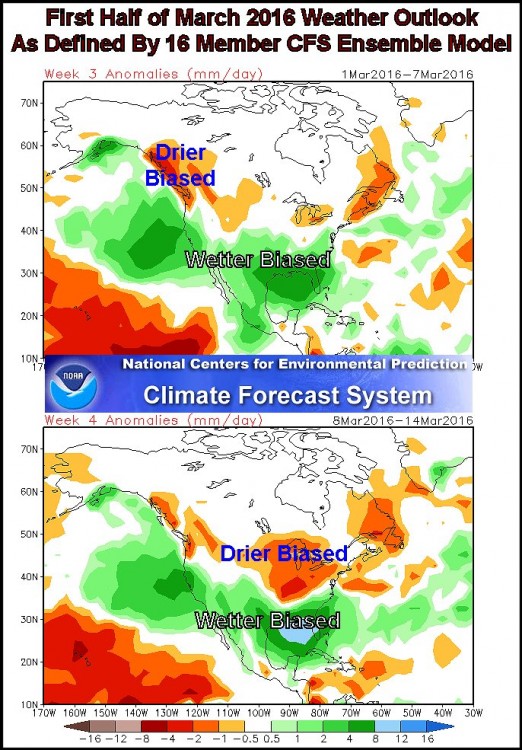
Changing atmospheric conditions are going to give El Nino the upper hand on weather trends once again as the month of February winds down and March begins. What is a traditional El Nino response?  Well, here in North America it will include a wet bias across the southern United States and northern Mexico to start with. A frequent succession of storms is advertised for southern portions of the region beginning late next week and going tempdeeply into March. These storms will carry large amounts of Pacific moisture inland through southern California and Baja California, Mexico. The storms will lose much of their moisture over the southwestern desert region and northern Mexico resulting in lighter rainfall in western and southern Texas and then the weather systems will attain Gulf of Mexico moisture to re-energize the precipitation potential as the disturbances continue to march east northeasterly through the Gulf of Mexico coast states and into a part of the interior southeastern states. In the meantime, the northern branch of the jet stream will see to it that very warm temperatures (that have already dominated western Canada and a part of the northwestern U.S. Plains) will expand back across southern Canada and the upper U.S. Midwest to the northeastern states. The return of warm air in these areas will likely be accompanied by less than usual precipitation.  These changes will end the recent bout of cold weather that has moved through the eastern half of the United States. Cooler air masses will still come along periodically, but no long lasting bitter cold is very likely for a while.


For other areas in the world, the changing influence of atmospheric patterns will be less visible. Western Canada will continue quite warm with a return to below average precipitation in the last days of February and the first half of March. Eastern Australia may struggle with dryness more often than over recent weeks and New Zealand may trend a little drier and warmer biased for a while in March. Drought in South Africa is expected to prevail for a while, although isolated to scattered showers and thunderstorms will continue periodically into the heart of March. Southeast Asia is expected to be influenced more by Madden Julian Oscillation (MJO) events than by El Nino and with El Nino continuing to weaken the odds are high that alternating periods of rain and sunshine will occur throughout Indonesia, Malaysia and the Philippines. Northeastern Brazil is expected to fall back into drier biased pattern for a while, but Argentina and most of Brazil’s main summer crop areas will continue to experience timely rainfall reinforcing the favorable production year that has been unfolding recently. West-central Africa may experience delayed seasonal rainfall in coffee, cocoa, sugarcane, rice and cotton production areas.


The most interesting part of this ENSO update in found in information released over the past few weeks has been reducing the amount of cooling that will take place in the equatorial eastern Pacific Ocean over the next few months. The trend has been suggesting a slower and slower weakening trend in El Nino and this week’s data suggests that El Nino might continue as a very weak event into the summer. That could change some forecaster’s outlooks for doom and gloom.  World Weather, Inc. sees no reason for a serious change in our outlook. El Nino will weaken enough that other weather patterns will take the lead for late spring and summer weather and we have already accounted for that.

June 23, 2016

No Comments

U.S. Weather Footprints Leave Hope For Summer Crops

This content is for members only

July 13, 2016

No Comments

U.S. High Pressure Ridge Has “Ruffles”

This content is for members only

August 24, 2016

No Comments

Too Much Hype – Just The Facts, Please

This content is for members only

December 14, 2017

No Comments

Weather Pattern Shift Likely In United States Dec. 20 – 22

This content is for members only

January 18, 2018

No Comments

Temperatures To Trend Above Avg. In Many U.S. Crop Areas

This content is for members only

May 15, 2018

No Comments

Assessing North America Summer Weather In Detail

This content is for members only

July 29, 2018

No Comments

East Australia Rainfall May Improve, According To SOI Data

This content is for members only

May 1, 2019

No Comments

SE U.S. May Have A Drier, Warmer-Biased Summer

This content is for members only

June 26, 2019

No Comments

Central U.S. Recovering From Significant Rain Of Last 60 Days

This content is for members only

December 23, 2019

No Comments

Late Week U.S. Storm To Impact Crops, Travel and Livestock

This content is for members only

February 6, 2020

No Comments

Audio Blog – Agricultural Weather Update For February 6


Welcome to World Weather, Inc.’s Audio Blog Page. You can either click on the hyperlink and listen to the recording here or you can right click on the hyperlink and download to your phone or desktop computer. The date shown will update when the recordings have been updated . For help, call (913) 383-1161 or email us at the address linked at the bottom of this page.

Agricultural Weather Update For U.S. and South America
Updated 02/06/20

February 12, 2021

No Comments

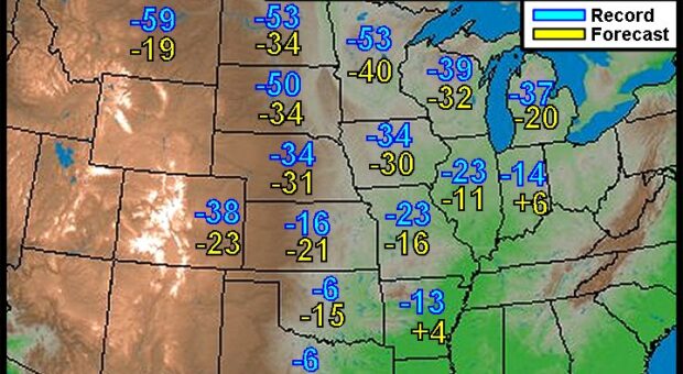
U.S. South Plains May See Record Cold After Snowstorm

This content is for members only

March 19, 2021

No Comments

Past Weather Experience Is Important For Forecasting

This content is for members only